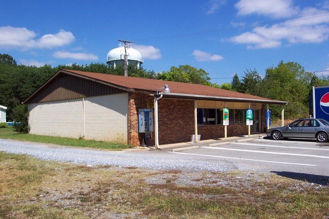
Property Record
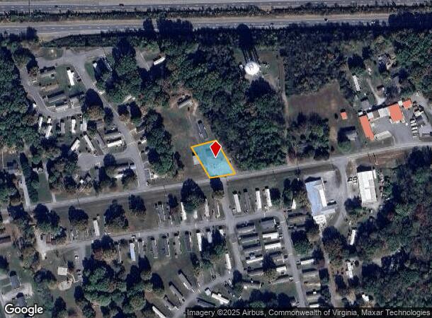
1853 Sunburst Rd, Evington, VA 24550
NEARBY LISTINGS FOR SALE OR LEASE
Property Detail
1853 Sunburst Rd
020000A0000086
Timberlake
Commercialnec
SUNBURST RD
X
Campbell
51019C0370D
Virginia
2025
0.30 AC
2025
Lynchburg
020403
Other Market Areas
880 SF
Lynchburg, VA
DEMOGRAPHICS near 1853 Sunburst Rd
1 Mile
3 Mile
5 Mile
2024 Total Population
3,057
23,300
51,075
2029 Population
3,017
23,186
51,409
Pop Growth 2024-2029
(1.31%)
(0.49%)
+ 0.65%
Average Age
41
40
39
2024 Total Households
1,243
9,631
20,855
HH Growth 2024-2029
(1.29%)
(0.53%)
+ 0.60%
Median Household Inc
$62,530
$61,725
$63,077
Avg Household Size
2.40
2.40
2.40
2024 Avg HH Vehicles
2.00
2.00
2.00
Median Home Value
$231,605
$212,133
$222,311
Median Year Built
1981
1983
1989
Nearby Places
Map Layers
Map Styles
 Street
 Aerial
- Restaurants
- Banks
- Shops
- Fitness
- Groceries
PUBLIC TRANSPORTATION
AIRPORT
Lynchburg Regional/Preston Glenn Field
DRIVE
WALK
Distance
Lynchburg Regional/Preston Glenn Field
10 min
4.0 mi
Freight Ports
Virginia Port Authority - Richmond
DRIVE
WALK
Distance
Virginia Port Authority - Richmond
159 min
117.5 mi
SALE & LEASE HISTORY
LISTING DATE
SALE/LEASE

Apr 14, 2017
For Sale
Nearby Properties
Address
Land Use
TOTAL SIZE
Lot Size
Zoning
Address
Land Use
TOTAL SIZE
Lot Size
Zoning
912 SF
52.88 AC
BGC
Address
Land Use
TOTAL SIZE
Lot Size
Zoning
36,168 SF
7.96 AC
BGC
Address
Land Use
TOTAL SIZE
Lot Size
Zoning
9,508 SF
8.54 AC
RMF
Address
Land Use
TOTAL SIZE
Lot Size
Zoning
1,120 SF
16.81 AC
RMF
Address
Land Use
TOTAL SIZE
Lot Size
Zoning
3,478 SF
13.10 AC
RMFC
Address
Land Use
TOTAL SIZE
Lot Size
Zoning
95,792 SF
3.28 AC
Address
Land Use
TOTAL SIZE
Lot Size
Zoning
22,170 SF
18.84 AC
BGC
Address
Land Use
TOTAL SIZE
Lot Size
Zoning
214,400 SF
98.14 AC
Address
Land Use
TOTAL SIZE
Lot Size
Zoning
23,633 SF
6.36 AC
RSF
Address
Land Use
TOTAL SIZE
Lot Size
Zoning
19,200 SF
17.13 AC
IG
Address
Land Use
TOTAL SIZE
Lot Size
Zoning
41,808 SF
12.16 AC
RSF
Address
Land Use
TOTAL SIZE
Lot Size
Zoning
95,130 SF
17.79 AC
090501
Address
Land Use
TOTAL SIZE
Lot Size
Zoning
22,928 SF
13.84 AC
Address
Land Use
TOTAL SIZE
Lot Size
Zoning
41,412 SF
5.87 AC
BGC
Address
Land Use
TOTAL SIZE
Lot Size
Zoning
2,695 SF
8.43 AC
BGC
Address
Land Use
TOTAL SIZE
Lot Size
Zoning
27,915 SF
28.48 AC
Address
Land Use
TOTAL SIZE
Lot Size
Zoning
41,264 SF
2.33 AC
BGC
Address
Land Use
TOTAL SIZE
Lot Size
Zoning
16,217 SF
9.44 AC
BGC
Address
Land Use
TOTAL SIZE
Lot Size
Zoning
54,495 SF
0.38 AC
Address
Land Use
TOTAL SIZE
Lot Size
Zoning
40,674 SF
0.35 AC
Address
Land Use
TOTAL SIZE
Lot Size
Zoning
30,232 SF
0.26 AC
Address
Land Use
TOTAL SIZE
Lot Size
Zoning
29,820 SF
0.26 AC
Address
Land Use
TOTAL SIZE
Lot Size
Zoning
6,696 SF
4.94 AC
RMF
Address
Land Use
TOTAL SIZE
Lot Size
Zoning
25,200 SF
13.88 AC
Address
Land Use
TOTAL SIZE
Lot Size
Zoning
27,684 SF
0.25 AC
Address
Land Use
TOTAL SIZE
Lot Size
Zoning
27,684 SF
0.25 AC
Address
Land Use
TOTAL SIZE
Lot Size
Zoning
27,568 SF
8.70 AC
BGC
Address
Land Use
TOTAL SIZE
Lot Size
Zoning
30,000 SF
2.88 AC
BGC
Address
Land Use
TOTAL SIZE
Lot Size
Zoning
90,253 SF
14.10 AC
Address
Land Use
TOTAL SIZE
Lot Size
Zoning
6,231 SF
5.06 AC
The World's #1 Commercial Real Estate Marketplace
Connect with us
© 2025 CoStar Group
The information above has been obtained from sources believed reliable. While we do not doubt its accuracy we have not verified it and make no guarantee, warranty or representation about it. It is your responsibility to independently confirm its accuracy and completeness. Any projections, opinions, assumptions, or estimates used are for example only and do not represent the current or future performance of the property. The value of this transaction to you depends on tax and other factors which should be evaluated by your tax, financial, and legal advisors. You and your advisors should conduct a careful, independent investigation of the property to determine to your satisfaction the suitability of the property for your needs.