Property Record
18522 Leslie Dr, Hagerstown, MD 21740

NEARBY LISTINGS FOR SALE OR LEASE
-
-
View all Hagerstown listings for lease on LoopNet.com
Property Detail
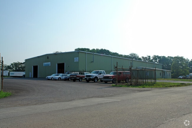
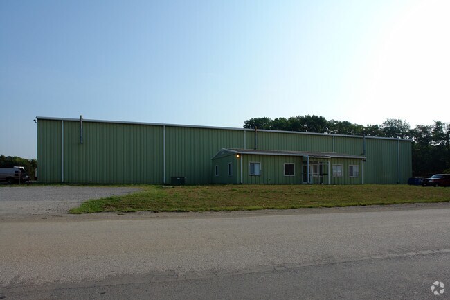
18522 Leslie Dr
10-005590
7.746 ACRES LOT 1 NE/S LESLIE DR
Warehouse
Washington
X
Maryland
24043C0305D
1
2024
7.74 AC
2025
Washington County
010901
Washington, DC
21,840 SF
Hagerstown-Martinsburg, MD-WV
DEMOGRAPHICS near 18522 Leslie Dr
1 Mile
3 Mile
5 Mile
2024 Total Population
3,560
13,257
61,287
2029 Population
3,628
13,517
62,172
Pop Growth 2024-2029
+ 1.91%
+ 1.96%
+ 1.44%
Average Age
37
41
41
2024 Total Households
1,128
5,033
24,661
HH Growth 2024-2029
+ 2.04%
+ 2.03%
+ 1.47%
Median Household Inc
$96,939
$87,347
$56,203
Avg Household Size
3.00
2.50
2.40
2024 Avg HH Vehicles
2.00
2.00
2.00
Median Home Value
$330,084
$275,052
$223,654
Median Year Built
2002
1986
1972
Nearby Places
Map Layers
Map Styles
 Street
 Aerial
- Restaurants
- Banks
- Shops
- Fitness
- Groceries
PUBLIC TRANSPORTATION
AIRPORT
Hagerstown Regional/Richard A Henson Field
DRIVE
WALK
Distance
Hagerstown Regional/Richard A Henson Field
19 min
9.9 mi
SALE & LEASE HISTORY
LISTING DATE
SALE/LEASE

Sep 24, 2016
For Lease
Nearby Properties
Address
Land Use
TOTAL SIZE
Lot Size
Zoning
Address
Land Use
TOTAL SIZE
Lot Size
Zoning
1,234,240 SF
134.80 AC
HI
Address
Land Use
TOTAL SIZE
Lot Size
Zoning
1,247,111 SF
74.55 AC
IMU
Address
Land Use
TOTAL SIZE
Lot Size
Zoning
6,683 SF
746.36 AC
U
Address
Land Use
TOTAL SIZE
Lot Size
Zoning
103,131 SF
53.74 AC
RMOD
Address
Land Use
TOTAL SIZE
Lot Size
Zoning
76.18 AC
U
Address
Land Use
TOTAL SIZE
Lot Size
Zoning
5,640 SF
31.48 AC
A(R)
Address
Land Use
TOTAL SIZE
Lot Size
Zoning
85,277 SF
13.62 AC
RT
Address
Land Use
TOTAL SIZE
Lot Size
Zoning
52,259 SF
60.86 AC
HI
Address
Land Use
TOTAL SIZE
Lot Size
Zoning
39,578 SF
64.90 AC
ORI
Address
Land Use
TOTAL SIZE
Lot Size
Zoning
138,132 SF
22.90 AC
HI
Address
Land Use
TOTAL SIZE
Lot Size
Zoning
28,584 SF
4.13 AC
HI
Address
Land Use
TOTAL SIZE
Lot Size
Zoning
16,102 SF
14 AC
ORI
Address
Land Use
TOTAL SIZE
Lot Size
Zoning
29,405 SF
29.47 AC
RH
Address
Land Use
TOTAL SIZE
Lot Size
Zoning
28,445 SF
49.29 AC
RT
Address
Land Use
TOTAL SIZE
Lot Size
Zoning
15.46 AC
RM
Address
Land Use
TOTAL SIZE
Lot Size
Zoning
80,430 SF
44.88 AC
ORI
Address
Land Use
TOTAL SIZE
Lot Size
Zoning
28,387 SF
11.54 AC
RU
Address
Land Use
TOTAL SIZE
Lot Size
Zoning
30,000 SF
8.39 AC
IG
Address
Land Use
TOTAL SIZE
Lot Size
Zoning
55,897 SF
4.30 AC
CG
Address
Land Use
TOTAL SIZE
Lot Size
Zoning
8,925 SF
10.30 AC
HI
Address
Land Use
TOTAL SIZE
Lot Size
Zoning
40,000 SF
9.22 AC
HI
Address
Land Use
TOTAL SIZE
Lot Size
Zoning
123 SF
7.25 AC
RM
Address
Land Use
TOTAL SIZE
Lot Size
Zoning
98,200 SF
10.74 AC
RH
Address
Land Use
TOTAL SIZE
Lot Size
Zoning
4.95 AC
U
Address
Land Use
TOTAL SIZE
Lot Size
Zoning
4,164 SF
15.14 AC
RH
Address
Land Use
TOTAL SIZE
Lot Size
Zoning
17,462 SF
8.81 AC
CG
Address
Land Use
TOTAL SIZE
Lot Size
Zoning
49,509 SF
7.36 AC
CG
Address
Land Use
TOTAL SIZE
Lot Size
Zoning
36,314 SF
16.62 AC
A(R)
Address
Land Use
TOTAL SIZE
Lot Size
Zoning
17,216 SF
2.47 AC
HI
Address
Land Use
TOTAL SIZE
Lot Size
Zoning
73,619 SF
39.23 AC
HI
The World's #1 Commercial Real Estate Marketplace
Connect with us
© 2025 CoStar Group
The information above has been obtained from sources believed reliable. While we do not doubt its accuracy we have not verified it and make no guarantee, warranty or representation about it. It is your responsibility to independently confirm its accuracy and completeness. Any projections, opinions, assumptions, or estimates used are for example only and do not represent the current or future performance of the property. The value of this transaction to you depends on tax and other factors which should be evaluated by your tax, financial, and legal advisors. You and your advisors should conduct a careful, independent investigation of the property to determine to your satisfaction the suitability of the property for your needs.