Property Record
18525 E Smoky Hill Rd, Centennial, CO 80015


Property Detail
18525 E Smoky Hill Rd
2073-15-2-32-001
SUBDIVISIONCD 036325 SUBDIVISIONNAME JACKSON FARMS COMMERCIAL SUB BLOCK 000 LOT 001 LOT 1 JACKSON FARMS COMMERCIAL SUB
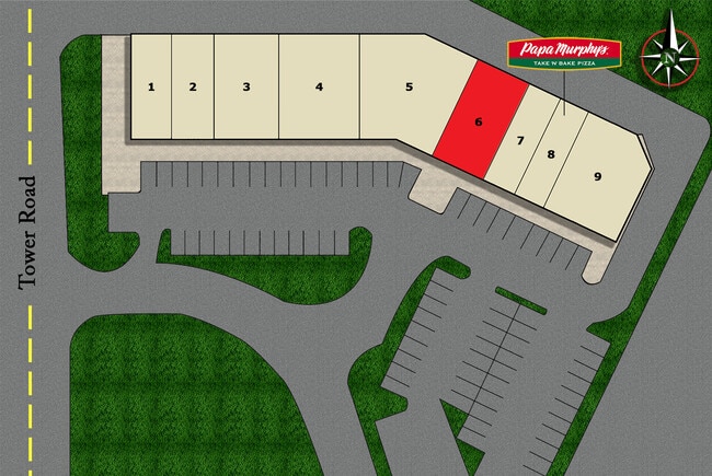
Storebuilding
ARAPAHOE
AMU
Colorado
B and X Area of moderate flood hazard, usually the area between the limits of the 100-year and 500-year floods.
001,1
2024
2.22 AC
2025
Southeast
085400
Denver
19,974 SF
Denver-Aurora-Centennial, CO
NEARBY LISTINGS FOR SALE OR LEASE
DEMOGRAPHICS near 18525 E Smoky Hill Rd
1 mile
3 mile
5 mile
2025 Total Population
18,275
136,561
262,956
2030 Population
18,264
137,639
266,906
Pop Growth 2025-2030
(0.06%)
+ 0.79%
+ 1.50%
Average Age
39
38
39
2025 Total Households
5,890
46,239
94,149
HH Growth 2025-2030
(0.03%)
+ 0.80%
+ 1.64%
Median Household Inc
$142,251
$121,063
$112,134
Avg Household Size
3.00
2.90
2.70
2025 Avg HH Vehicles
2.00
2.00
2.00
Median Home Value
$661,322
$617,779
$590,643
Median Year Built
1990
1991
1993
Nearby Places
Map Layers
Map Styles
 Street
 Aerial
Layers
 Traffic
 Biking
Places
Listings with unknown addresses are not visible on the map
- Restaurants
- Banks
- Shops
- Fitness
- Groceries
PUBLIC TRANSPORTATION
AIRPORT
Denver International
Drive
Walk
Distance
Denver International
33 min
26.1 mi
SALE & LEASE HISTORY
LISTING DATE
SALE/LEASE

Sep 24, 2016
For Lease
Oct 08, 2020
For Lease
Nearby Properties
Address
Land Use
TOTAL SIZE
Lot Size
Zoning
Address
Land Use
TOTAL SIZE
Lot Size
Zoning
234,214 SF
5.23 AC
Address
Land Use
TOTAL SIZE
Lot Size
Zoning
280,586 SF
60.97 AC
RPD
Address
Land Use
TOTAL SIZE
Lot Size
Zoning
525,600 SF
57.90 AC
Address
Land Use
TOTAL SIZE
Lot Size
Zoning
346,890 SF
38.99 AC
AA1
Address
Land Use
TOTAL SIZE
Lot Size
Zoning
103,811 SF
6.36 AC
RPD
Address
Land Use
TOTAL SIZE
Lot Size
Zoning
328,000 SF
33.52 AC
PUD
Address
Land Use
TOTAL SIZE
Lot Size
Zoning
217,273 SF
18.28 AC
Address
Land Use
TOTAL SIZE
Lot Size
Zoning
142,378 SF
14.64 AC
Address
Land Use
TOTAL SIZE
Lot Size
Zoning
168,500 SF
24.03 AC
Address
Land Use
TOTAL SIZE
Lot Size
Zoning
166,431 SF
19.37 AC
Address
Land Use
TOTAL SIZE
Lot Size
Zoning
122,965 SF
12.30 AC
RPD
Address
Land Use
TOTAL SIZE
Lot Size
Zoning
12,726 SF
17.94 AC
Address
Land Use
TOTAL SIZE
Lot Size
Zoning
368,462 SF
11.68 AC
RZMF
Address
Land Use
TOTAL SIZE
Lot Size
Zoning
106,000 SF
27.41 AC
Address
Land Use
TOTAL SIZE
Lot Size
Zoning
376,563 SF
12.17 AC
AMU
Address
Land Use
TOTAL SIZE
Lot Size
Zoning
383,969 SF
14.83 AC
AMU
Address
Land Use
TOTAL SIZE
Lot Size
Zoning
176,000 SF
10.83 AC
PUD
Address
Land Use
TOTAL SIZE
Lot Size
Zoning
105,244 SF
12.64 AC
RPCZD
Address
Land Use
TOTAL SIZE
Lot Size
Zoning
308,396 SF
19.45 AC
RPCZD
Address
Land Use
TOTAL SIZE
Lot Size
Zoning
26,880 SF
20.44 AC
Address
Land Use
TOTAL SIZE
Lot Size
Zoning
298,589 SF
14.52 AC
RPCZD
Address
Land Use
TOTAL SIZE
Lot Size
Zoning
220,184 SF
20.45 AC
RPD
Address
Land Use
TOTAL SIZE
Lot Size
Zoning
206,064 SF
25.38 AC
AMU
Address
Land Use
TOTAL SIZE
Lot Size
Zoning
172,715 SF
4.23 AC
Address
Land Use
TOTAL SIZE
Lot Size
Zoning
344,071 SF
17.10 AC
Address
Land Use
TOTAL SIZE
Lot Size
Zoning
114,838 SF
12.50 AC
Address
Land Use
TOTAL SIZE
Lot Size
Zoning
303,614 SF
15.49 AC
RR2
Address
Land Use
TOTAL SIZE
Lot Size
Zoning
84,662 SF
8.14 AC
PUD
Address
Land Use
TOTAL SIZE
Lot Size
Zoning
255,676 SF
13.97 AC
PUD
Address
Land Use
TOTAL SIZE
Lot Size
Zoning
140,000 SF
24.16 AC
AMU
The World's #1 Commercial Real Estate Marketplace
Connect with us
© 2026 CoStar Group
The information above has been obtained from sources believed reliable. While we do not doubt its accuracy we have not verified it and make no guarantee, warranty or representation about it. It is your responsibility to independently confirm its accuracy and completeness. Any projections, opinions, assumptions, or estimates used are for example only and do not represent the current or future performance of the property. The value of this transaction to you depends on tax and other factors which should be evaluated by your tax, financial, and legal advisors. You and your advisors should conduct a careful, independent investigation of the property to determine to your satisfaction the suitability of the property for your needs.