Property Record
1853 Donnell Rd, West Palm Beach, FL 33409
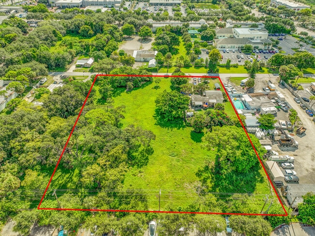
This Property Is For Sale
NEARBY LISTINGS FOR SALE OR LEASE
Property Detail
1853 Donnell Rd
00-42-43-25-00-000-1481
Acreage & Unrec
Sfr
25-43-42~ N 185 FT OF W 1/2 OFSW 1/4 OF NE 1/4 OF NE 1/4 (LESS E 10 FT RD R/W)
X
Palm Beach
12099C0578F
Florida
2024
0.64 AC
2024
West Palm Beach
002900
South Florida
974 SF
West Palm Beach-Boca Raton-Delray Beach, FL
DEMOGRAPHICS near 1853 Donnell Rd
1 Mile
3 Mile
5 Mile
2024 Total Population
15,237
118,061
286,472
2029 Population
15,744
122,857
297,520
Pop Growth 2024-2029
+ 3.33%
+ 4.06%
+ 3.86%
Average Age
34
40
40
2024 Total Households
4,913
47,329
112,211
HH Growth 2024-2029
+ 2.69%
+ 3.89%
+ 3.61%
Median Household Inc
$44,882
$50,854
$54,504
Avg Household Size
2.90
2.30
2.40
2024 Avg HH Vehicles
2.00
1.00
2.00
Median Home Value
$223,175
$215,585
$259,314
Median Year Built
1983
1984
1982
Nearby Places
- Restaurants
- Banks
- Shops
- Fitness
- Groceries
PUBLIC TRANSPORTATION
COMMUTER RAIL
West Palm Beach (Tri-County Commuter - South Florida Regional Transportation Authority (Tri-Rail))
DRIVE
WALK
Distance
West Palm Beach (Tri-County Commuter - South Florida Regional Transportation Authority (Tri-Rail))
8 min
3.4 mi
DRIVE
WALK
Distance
9 min
3.9 mi
AIRPORT
Palm Beach International
DRIVE
WALK
Distance
Palm Beach International
9 min
3.5 mi
Freight Ports
Port of Palm Beach
DRIVE
WALK
Distance
Port of Palm Beach
16 min
7.4 mi
Nearby Properties
Address
Land Use
TOTAL SIZE
Lot Size
Zoning
Address
Land Use
TOTAL SIZE
Lot Size
Zoning
3,150,355 SF
616.71 AC
PO
Address
Land Use
TOTAL SIZE
Lot Size
Zoning
492,288 SF
58.52 AC
CPD
Address
Land Use
TOTAL SIZE
Lot Size
Zoning
981,713 SF
77.89 AC
PO
Address
Land Use
TOTAL SIZE
Lot Size
Zoning
1,111,012 SF
19.48 AC
CPD
Address
Land Use
TOTAL SIZE
Lot Size
Zoning
441,083 SF
432.02 AC
PO
Address
Land Use
TOTAL SIZE
Lot Size
Zoning
596,079 SF
21.49 AC
RPD
Address
Land Use
TOTAL SIZE
Lot Size
Zoning
490,757 SF
12.11 AC
PIPD
Address
Land Use
TOTAL SIZE
Lot Size
Zoning
303,776 SF
27.67 AC
CPD
Address
Land Use
TOTAL SIZE
Lot Size
Zoning
586,386 SF
19.67 AC
RPD
Address
Land Use
TOTAL SIZE
Lot Size
Zoning
546,847 SF
19.50 AC
RPD
Address
Land Use
TOTAL SIZE
Lot Size
Zoning
419,633 SF
5.13 AC
CPD
Address
Land Use
TOTAL SIZE
Lot Size
Zoning
480,432 SF
45.30 AC
MUPD
Address
Land Use
TOTAL SIZE
Lot Size
Zoning
303,654 SF
6.93 AC
TOD-10
Address
Land Use
TOTAL SIZE
Lot Size
Zoning
561,484 SF
21.86 AC
PO
Address
Land Use
TOTAL SIZE
Lot Size
Zoning
273,101 SF
19.32 AC
CAD-5
Address
Land Use
TOTAL SIZE
Lot Size
Zoning
404,222 SF
36.71 AC
RH
Address
Land Use
TOTAL SIZE
Lot Size
Zoning
347,853 SF
46.24 AC
PIPD
Address
Land Use
TOTAL SIZE
Lot Size
Zoning
150,344 SF
200.99 AC
PO
Address
Land Use
TOTAL SIZE
Lot Size
Zoning
406,623 SF
47.23 AC
MF14
Address
Land Use
TOTAL SIZE
Lot Size
Zoning
276,247 SF
2.48 AC
CPD
Address
Land Use
TOTAL SIZE
Lot Size
Zoning
444,168 SF
2.90 AC
FWD-5
Address
Land Use
TOTAL SIZE
Lot Size
Zoning
173,543 SF
3.18 AC
CPD
Address
Land Use
TOTAL SIZE
Lot Size
Zoning
371,177 SF
17.38 AC
RPD
Address
Land Use
TOTAL SIZE
Lot Size
Zoning
293,524 SF
11.14 AC
RPD
Address
Land Use
TOTAL SIZE
Lot Size
Zoning
328,512 SF
15.27 AC
PUD
Address
Land Use
TOTAL SIZE
Lot Size
Zoning
210,445 SF
11.18 AC
MUPD
Address
Land Use
TOTAL SIZE
Lot Size
Zoning
302,217 SF
18.17 AC
RPD
Address
Land Use
TOTAL SIZE
Lot Size
Zoning
232,751 SF
12.67 AC
RPD
Address
Land Use
TOTAL SIZE
Lot Size
Zoning
247,028 SF
14.30 AC
RS
Address
Land Use
TOTAL SIZE
Lot Size
Zoning
275,703 SF
27.32 AC
PO
The World's #1 Commercial Real Estate Marketplace
Connect with us
© 2025 CoStar Group
The information above has been obtained from sources believed reliable. While we do not doubt its accuracy we have not verified it and make no guarantee, warranty or representation about it. It is your responsibility to independently confirm its accuracy and completeness. Any projections, opinions, assumptions, or estimates used are for example only and do not represent the current or future performance of the property. The value of this transaction to you depends on tax and other factors which should be evaluated by your tax, financial, and legal advisors. You and your advisors should conduct a careful, independent investigation of the property to determine to your satisfaction the suitability of the property for your needs.