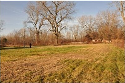
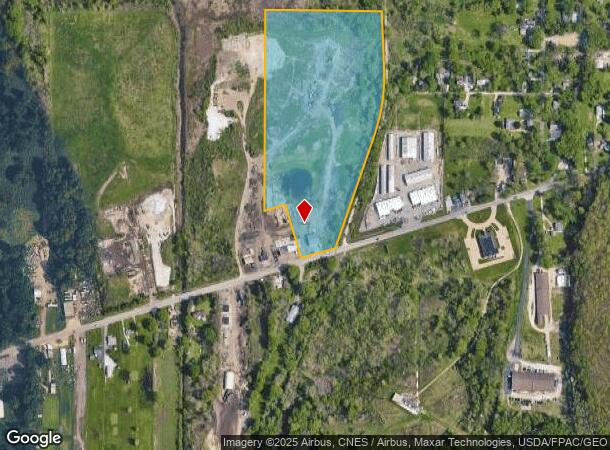
Property Record
1853 Wadsworth Rd, Barberton, OH 44203
NEARBY LISTINGS FOR SALE OR LEASE
Property Detail
1853 Wadsworth Rd
Akron, OH
Wadsworth
46-06160
LOT 10 NW N OF AKRON WADSWORTH RD
Commercialnec
Summit
AE
Ohio
39153C0186F
10
2023
18.79 AC
2025
Akron
510100
Cleveland
1,875 SF
DEMOGRAPHICS near 1853 Wadsworth Rd
1 Mile
3 Mile
5 Mile
2024 Total Population
947
54,633
153,251
2029 Population
939
54,364
152,154
Pop Growth 2024-2029
(0.84%)
(0.49%)
(0.72%)
Average Age
44
40
41
2024 Total Households
418
23,406
66,731
HH Growth 2024-2029
(0.72%)
(0.55%)
(0.74%)
Median Household Inc
$50,429
$42,716
$46,192
Avg Household Size
2.20
2.20
2.20
2024 Avg HH Vehicles
2.00
2.00
2.00
Median Home Value
$138,554
$88,656
$127,528
Median Year Built
1964
1953
1954
Nearby Places
Map Layers
Map Styles
 Street
 Aerial
- Restaurants
- Banks
- Shops
- Fitness
- Groceries
PUBLIC TRANSPORTATION
COMMUTER RAIL
Akron Northside (National Park Scenic Railway - Cuyahoga Valley Scenic Railroad)
DRIVE
WALK
Distance
Akron Northside (National Park Scenic Railway - Cuyahoga Valley Scenic Railroad)
11 min
6.2 mi
Big Bend (National Park Scenic Railway - Cuyahoga Valley Scenic Railroad)
DRIVE
WALK
Distance
Big Bend (National Park Scenic Railway - Cuyahoga Valley Scenic Railroad)
16 min
8.7 mi
AIRPORT
Akron-Canton Regional
DRIVE
WALK
Distance
Akron-Canton Regional
24 min
16.3 mi
Cleveland-Hopkins International
DRIVE
WALK
Distance
Cleveland-Hopkins International
55 min
39.0 mi
Freight Ports
Port of Toledo
DRIVE
WALK
Distance
Port of Toledo
158 min
134.2 mi
Nearby Properties
Address
Land Use
TOTAL SIZE
Lot Size
Zoning
Address
Land Use
TOTAL SIZE
Lot Size
Zoning
1,397,532 SF
92.95 AC
Address
Land Use
TOTAL SIZE
Lot Size
Zoning
148,344 SF
40.32 AC
Address
Land Use
TOTAL SIZE
Lot Size
Zoning
252,222 SF
12.65 AC
Address
Land Use
TOTAL SIZE
Lot Size
Zoning
246,312 SF
17.50 AC
Address
Land Use
TOTAL SIZE
Lot Size
Zoning
166,625 SF
11.37 AC
Address
Land Use
TOTAL SIZE
Lot Size
Zoning
231,968 SF
29.14 AC
Address
Land Use
TOTAL SIZE
Lot Size
Zoning
184,791 SF
3.25 AC
Address
Land Use
TOTAL SIZE
Lot Size
Zoning
10.26 AC
Address
Land Use
TOTAL SIZE
Lot Size
Zoning
54,398 SF
8.10 AC
Address
Land Use
TOTAL SIZE
Lot Size
Zoning
148.10 AC
Address
Land Use
TOTAL SIZE
Lot Size
Zoning
209,183 SF
36.34 AC
Address
Land Use
TOTAL SIZE
Lot Size
Zoning
99,931 SF
16.82 AC
Address
Land Use
TOTAL SIZE
Lot Size
Zoning
253,690 SF
12.18 AC
Address
Land Use
TOTAL SIZE
Lot Size
Zoning
59,492 SF
5.51 AC
Address
Land Use
TOTAL SIZE
Lot Size
Zoning
63,918 SF
4.95 AC
Address
Land Use
TOTAL SIZE
Lot Size
Zoning
28,920 SF
2.40 AC
Address
Land Use
TOTAL SIZE
Lot Size
Zoning
113,321 SF
13.32 AC
Address
Land Use
TOTAL SIZE
Lot Size
Zoning
52,270 SF
3.89 AC
Address
Land Use
TOTAL SIZE
Lot Size
Zoning
125,245 SF
6.11 AC
Address
Land Use
TOTAL SIZE
Lot Size
Zoning
20,000 SF
23.71 AC
Address
Land Use
TOTAL SIZE
Lot Size
Zoning
5,520 SF
68.52 AC
Address
Land Use
TOTAL SIZE
Lot Size
Zoning
31,348 SF
2.32 AC
Address
Land Use
TOTAL SIZE
Lot Size
Zoning
20,280 SF
2.24 AC
Address
Land Use
TOTAL SIZE
Lot Size
Zoning
40,006 SF
4.85 AC
Address
Land Use
TOTAL SIZE
Lot Size
Zoning
56,967 SF
1.62 AC
Address
Land Use
TOTAL SIZE
Lot Size
Zoning
75,284 SF
5 AC
Address
Land Use
TOTAL SIZE
Lot Size
Zoning
80,198 SF
5.70 AC
Address
Land Use
TOTAL SIZE
Lot Size
Zoning
46,338 SF
1.72 AC
Address
Land Use
TOTAL SIZE
Lot Size
Zoning
208,318 SF
8.37 AC
Address
Land Use
TOTAL SIZE
Lot Size
Zoning
3.88 AC
The World's #1 Commercial Real Estate Marketplace
Connect with us
© 2026 CoStar Group
The information above has been obtained from sources believed reliable. While we do not doubt its accuracy we have not verified it and make no guarantee, warranty or representation about it. It is your responsibility to independently confirm its accuracy and completeness. Any projections, opinions, assumptions, or estimates used are for example only and do not represent the current or future performance of the property. The value of this transaction to you depends on tax and other factors which should be evaluated by your tax, financial, and legal advisors. You and your advisors should conduct a careful, independent investigation of the property to determine to your satisfaction the suitability of the property for your needs.