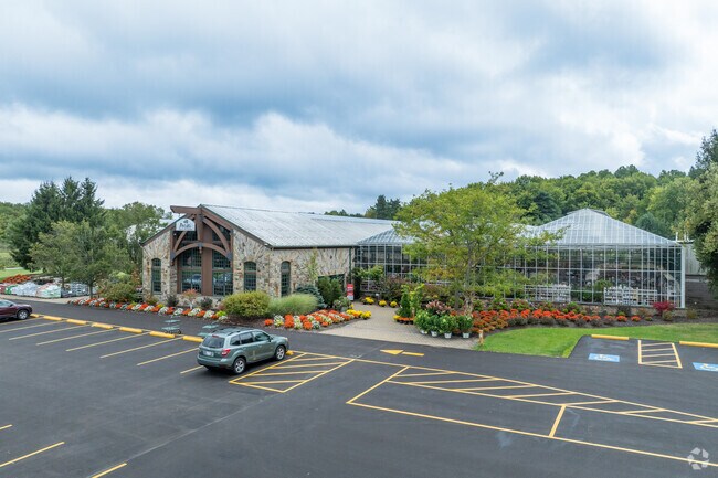
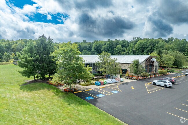
Property Record
18548 Chillicothe Rd, Chagrin Falls, OH 44023

Property Detail
18548 Chillicothe Rd
02-420659
LOT 15 TR 3
Commercialnec
Geauga
R5A
Ohio
B and X Area of moderate flood hazard, usually the area between the limits of the 100-year and 500-year floods.
15
2025
10.28 AC
2025
Geauga County
311800
Cleveland
10,320 SF
Cleveland-Elyria, OH
NEARBY LISTINGS FOR SALE OR LEASE
DEMOGRAPHICS near 18548 Chillicothe Rd
1 mile
3 mile
5 mile
2025 Total Population
1,863
16,187
54,776
2030 Population
1,858
16,217
54,744
Pop Growth 2025-2030
(0.27%)
+ 0.19%
(0.06%)
Average Age
45
45
44
2025 Total Households
691
6,073
20,696
HH Growth 2025-2030
(0.29%)
+ 0.18%
(0.06%)
Median Household Inc
$115,060
$123,730
$123,789
Avg Household Size
2.70
2.60
2.60
2025 Avg HH Vehicles
2.00
2.00
2.00
Median Home Value
$389,436
$421,419
$413,022
Median Year Built
1978
1984
1987
Nearby Places
Map Layers
Map Styles
 Street
 Aerial
Layers
 Traffic
 Biking
Places
Listings with unknown addresses are not visible on the map
- Restaurants
- Banks
- Shops
- Fitness
- Groceries
PUBLIC TRANSPORTATION
AIRPORT
Cleveland-Hopkins International
Drive
Walk
Distance
Cleveland-Hopkins International
45 min
30.9 mi
Akron-Canton Regional
Drive
Walk
Distance
Akron-Canton Regional
61 min
41.1 mi
Nearby Properties
Address
Land Use
TOTAL SIZE
Lot Size
Zoning
Address
Land Use
TOTAL SIZE
Lot Size
Zoning
227,389 SF
27.75 AC
R5A
Address
Land Use
TOTAL SIZE
Lot Size
Zoning
79,668 SF
14 AC
R5A
Address
Land Use
TOTAL SIZE
Lot Size
Zoning
116,598 SF
43.36 AC
CR
Address
Land Use
TOTAL SIZE
Lot Size
Zoning
151,032 SF
40.13 AC
Address
Land Use
TOTAL SIZE
Lot Size
Zoning
177,246 SF
40.56 AC
R5A
Address
Land Use
TOTAL SIZE
Lot Size
Zoning
100,601 SF
40.70 AC
R5A
Address
Land Use
TOTAL SIZE
Lot Size
Zoning
153,194 SF
11.31 AC
Address
Land Use
TOTAL SIZE
Lot Size
Zoning
116,597 SF
11.36 AC
CR
Address
Land Use
TOTAL SIZE
Lot Size
Zoning
62,067 SF
30.96 AC
Address
Land Use
TOTAL SIZE
Lot Size
Zoning
61,222 SF
19.01 AC
Address
Land Use
TOTAL SIZE
Lot Size
Zoning
194,480 SF
17.77 AC
CR
Address
Land Use
TOTAL SIZE
Lot Size
Zoning
106,440 SF
14.25 AC
CR
Address
Land Use
TOTAL SIZE
Lot Size
Zoning
120,010 SF
11.92 AC
CB
Address
Land Use
TOTAL SIZE
Lot Size
Zoning
3,124 SF
60.91 AC
R3A
Address
Land Use
TOTAL SIZE
Lot Size
Zoning
127,518 SF
13.10 AC
CR
Address
Land Use
TOTAL SIZE
Lot Size
Zoning
24.54 AC
Address
Land Use
TOTAL SIZE
Lot Size
Zoning
25,288 SF
28.71 AC
CR
Address
Land Use
TOTAL SIZE
Lot Size
Zoning
86,970 SF
8.33 AC
CR
Address
Land Use
TOTAL SIZE
Lot Size
Zoning
30,295 SF
7.12 AC
R5A
Address
Land Use
TOTAL SIZE
Lot Size
Zoning
30,862 SF
13.40 AC
Address
Land Use
TOTAL SIZE
Lot Size
Zoning
50,024 SF
3.70 AC
Address
Land Use
TOTAL SIZE
Lot Size
Zoning
16.45 AC
Address
Land Use
TOTAL SIZE
Lot Size
Zoning
92,734 SF
178.37 AC
R-1-F
Address
Land Use
TOTAL SIZE
Lot Size
Zoning
33,848 SF
4.25 AC
Address
Land Use
TOTAL SIZE
Lot Size
Zoning
45,680 SF
45.21 AC
Address
Land Use
TOTAL SIZE
Lot Size
Zoning
30,650 SF
9.58 AC
Address
Land Use
TOTAL SIZE
Lot Size
Zoning
25,446 SF
77.58 AC
Address
Land Use
TOTAL SIZE
Lot Size
Zoning
78.29 AC
CR
Address
Land Use
TOTAL SIZE
Lot Size
Zoning
56.45 AC
CR
Address
Land Use
TOTAL SIZE
Lot Size
Zoning
5,002 SF
105.70 AC
R5A
The World's #1 Commercial Real Estate Marketplace
Connect with us
© 2026 CoStar Group
The information above has been obtained from sources believed reliable. While we do not doubt its accuracy we have not verified it and make no guarantee, warranty or representation about it. It is your responsibility to independently confirm its accuracy and completeness. Any projections, opinions, assumptions, or estimates used are for example only and do not represent the current or future performance of the property. The value of this transaction to you depends on tax and other factors which should be evaluated by your tax, financial, and legal advisors. You and your advisors should conduct a careful, independent investigation of the property to determine to your satisfaction the suitability of the property for your needs.