No Photo
Property Record
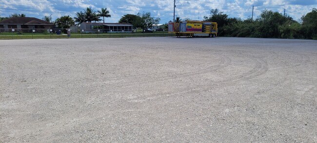
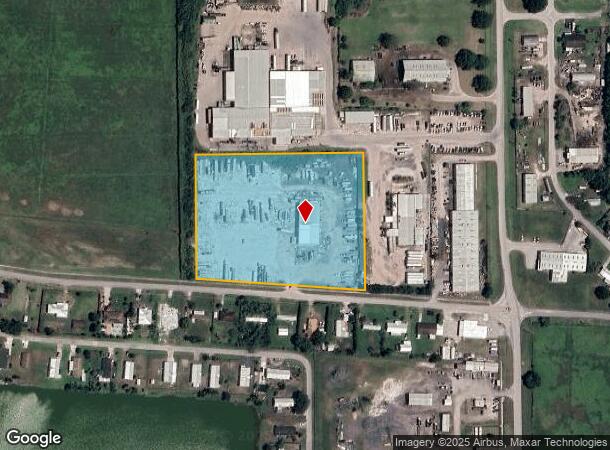
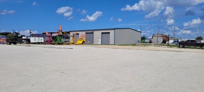
1855 Hookers Point Rd, Clewiston, FL 33440
NEARBY LISTINGS FOR SALE OR LEASE
Property Detail
1855 Hookers Point Rd
1-34-43-23-A00-0003-0700
BEG NW COR SEC 23-N 89 DEG 24M 24S E 4198.54 FT-S 00 DEG 30M 21S E 1264.5 FT TO POB-N 89 DEG 29M 24S E 589.66 FT-S 00 DEG 30M 21S E 477.29 FT-N 86 DEG 21M 09S W 591.21 FT-N 00 DEG 30M 21S W 434.42 FT TO POB 6.18 AC
Warehouse
Hendry
X
Florida
12051C0285E
700
2025
6.18 AC
2025
Florida Central South Area
000200
Other Market Areas
11,464 SF
Clewiston, FL
DEMOGRAPHICS near 1855 Hookers Point Rd
1 Mile
3 Mile
5 Mile
2024 Total Population
3,553
12,399
13,922
2029 Population
3,886
13,515
15,176
Pop Growth 2024-2029
+ 9.37%
+ 9.00%
+ 9.01%
Average Age
36
37
37
2024 Total Households
1,053
4,061
4,609
HH Growth 2024-2029
+ 10.16%
+ 9.60%
+ 9.57%
Median Household Inc
$64,920
$42,335
$41,595
Avg Household Size
3.00
2.90
2.90
2024 Avg HH Vehicles
2.00
2.00
2.00
Median Home Value
$104,187
$120,257
$121,111
Median Year Built
1994
1986
1985
Nearby Places
Map Layers
Map Styles
 Street
 Aerial
- Restaurants
- Banks
- Shops
- Fitness
- Groceries
SALE & LEASE HISTORY
LISTING DATE
SALE/LEASE

May 05, 2023
For Lease
Nearby Properties
Address
Land Use
TOTAL SIZE
Lot Size
Zoning
Address
Land Use
TOTAL SIZE
Lot Size
Zoning
16,790.35 AC
A-2
Address
Land Use
TOTAL SIZE
Lot Size
Zoning
105,692 SF
9.13 AC
CL-P
Address
Land Use
TOTAL SIZE
Lot Size
Zoning
823,813 SF
109.02 AC
A-2
Address
Land Use
TOTAL SIZE
Lot Size
Zoning
159,172 SF
2.58 AC
CL-P
Address
Land Use
TOTAL SIZE
Lot Size
Zoning
140 AC
PUD
Address
Land Use
TOTAL SIZE
Lot Size
Zoning
155,374 SF
47.27 AC
CL-R2
Address
Land Use
TOTAL SIZE
Lot Size
Zoning
132,618 SF
3.92 AC
A-2
Address
Land Use
TOTAL SIZE
Lot Size
Zoning
648 SF
74 AC
I-2
Address
Land Use
TOTAL SIZE
Lot Size
Zoning
40,010 SF
19.71 AC
CL-P
Address
Land Use
TOTAL SIZE
Lot Size
Zoning
116,156 SF
18.12 AC
RG4
Address
Land Use
TOTAL SIZE
Lot Size
Zoning
200,797 SF
45.50 AC
CL-P
Address
Land Use
TOTAL SIZE
Lot Size
Zoning
12,954 SF
163.12 AC
CL-P
Address
Land Use
TOTAL SIZE
Lot Size
Zoning
36,761 SF
19.62 AC
CL-C
Address
Land Use
TOTAL SIZE
Lot Size
Zoning
52,935 SF
1.31 AC
CL-C
Address
Land Use
TOTAL SIZE
Lot Size
Zoning
3,756 SF
28.49 AC
CL-P
Address
Land Use
TOTAL SIZE
Lot Size
Zoning
70,800 SF
3.33 AC
CL-R3
Address
Land Use
TOTAL SIZE
Lot Size
Zoning
23,486 SF
21.23 AC
CL-P
Address
Land Use
TOTAL SIZE
Lot Size
Zoning
99,454 SF
40.65 AC
PUD
Address
Land Use
TOTAL SIZE
Lot Size
Zoning
144,708 SF
11.42 AC
CL-C
Address
Land Use
TOTAL SIZE
Lot Size
Zoning
32,356 SF
7.58 AC
CL-R3
Address
Land Use
TOTAL SIZE
Lot Size
Zoning
43,875 SF
1.17 AC
A-2
Address
Land Use
TOTAL SIZE
Lot Size
Zoning
18,093 SF
0.51 AC
CL-C
Address
Land Use
TOTAL SIZE
Lot Size
Zoning
137,500 SF
20.17 AC
A-2
Address
Land Use
TOTAL SIZE
Lot Size
Zoning
89,194 SF
9.32 AC
CL-C
Address
Land Use
TOTAL SIZE
Lot Size
Zoning
74 AC
I-2
Address
Land Use
TOTAL SIZE
Lot Size
Zoning
26,030 SF
10.16 AC
C-1
Address
Land Use
TOTAL SIZE
Lot Size
Zoning
17,884 SF
8.92 AC
CL-I
Address
Land Use
TOTAL SIZE
Lot Size
Zoning
93,994 SF
8.73 AC
C-3
Address
Land Use
TOTAL SIZE
Lot Size
Zoning
40 AC
I-2
Address
Land Use
TOTAL SIZE
Lot Size
Zoning
960 SF
69.50 AC
A-2
The World's #1 Commercial Real Estate Marketplace
Connect with us
© 2026 CoStar Group
The information above has been obtained from sources believed reliable. While we do not doubt its accuracy we have not verified it and make no guarantee, warranty or representation about it. It is your responsibility to independently confirm its accuracy and completeness. Any projections, opinions, assumptions, or estimates used are for example only and do not represent the current or future performance of the property. The value of this transaction to you depends on tax and other factors which should be evaluated by your tax, financial, and legal advisors. You and your advisors should conduct a careful, independent investigation of the property to determine to your satisfaction the suitability of the property for your needs.