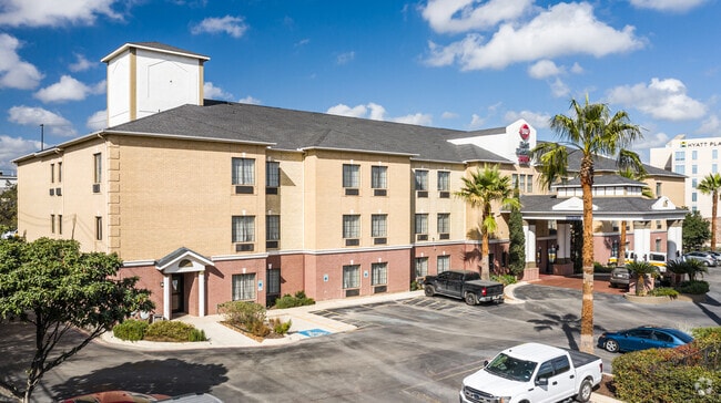
Property Record
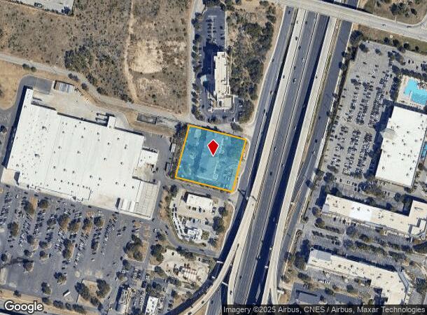
18555 Us Highway 281 N, San Antonio, TX 78258
NEARBY LISTINGS FOR SALE OR LEASE
-
-
View all San Antonio listings for sale on LoopNet.com
Property Detail
18555 Us Highway 281 N
San Antonio-New Braunfels, TX
Sampat Sub
17225-001-0100
NCB 17225 BLK 1 LOT 10 SAMPAT SUBD
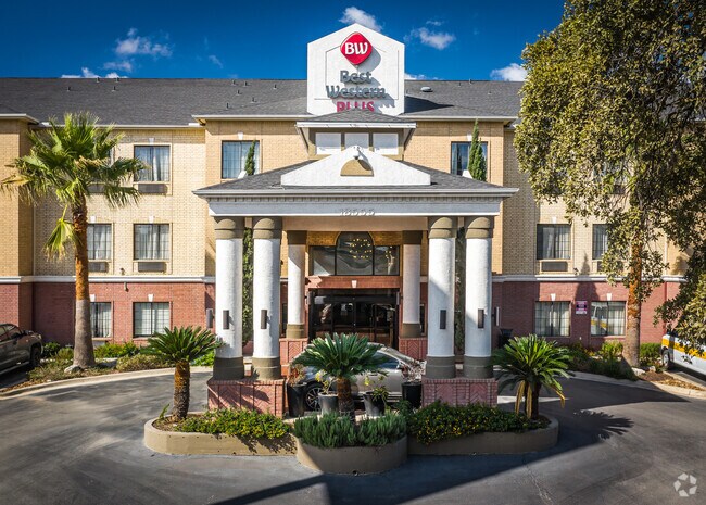
Hotel
Bexar
X
Texas
48029C0255G
10
2024
1.71 AC
2025
San Antonio Airport
191818
San Antonio
48,534 SF
DEMOGRAPHICS near 18555 Us Highway 281 N
1 Mile
3 Mile
5 Mile
2024 Total Population
6,690
84,221
221,430
2029 Population
7,168
89,952
235,603
Pop Growth 2024-2029
+ 7.14%
+ 6.80%
+ 6.40%
Average Age
39
40
39
2024 Total Households
2,859
33,902
86,532
HH Growth 2024-2029
+ 7.35%
+ 7.03%
+ 6.57%
Median Household Inc
$78,440
$91,664
$90,994
Avg Household Size
2.30
2.40
2.50
2024 Avg HH Vehicles
2.00
2.00
2.00
Median Home Value
$328,272
$315,137
$319,352
Median Year Built
1997
1996
1997
Nearby Places
Map Layers
Map Styles
 Street
 Aerial
- Restaurants
- Banks
- Shops
- Fitness
- Groceries
PUBLIC TRANSPORTATION
AIRPORT
San Antonio International
DRIVE
WALK
Distance
San Antonio International
9 min
6.9 mi
Freight Ports
Calhoun Port
DRIVE
WALK
Distance
Calhoun Port
186 min
155.8 mi
Nearby Properties
Address
Land Use
TOTAL SIZE
Lot Size
Zoning
Address
Land Use
TOTAL SIZE
Lot Size
Zoning
621,591 SF
15.25 AC
Address
Land Use
TOTAL SIZE
Lot Size
Zoning
427,456 SF
37.12 AC
Address
Land Use
TOTAL SIZE
Lot Size
Zoning
631,284 SF
14.61 AC
Address
Land Use
TOTAL SIZE
Lot Size
Zoning
387,893 SF
11.97 AC
Address
Land Use
TOTAL SIZE
Lot Size
Zoning
435,882 SF
27.85 AC
Address
Land Use
TOTAL SIZE
Lot Size
Zoning
391,871 SF
17.94 AC
Address
Land Use
TOTAL SIZE
Lot Size
Zoning
352,144 SF
29.83 AC
Address
Land Use
TOTAL SIZE
Lot Size
Zoning
311,728 SF
7.47 AC
Address
Land Use
TOTAL SIZE
Lot Size
Zoning
383,541 SF
12.41 AC
Address
Land Use
TOTAL SIZE
Lot Size
Zoning
292,126 SF
12.86 AC
Address
Land Use
TOTAL SIZE
Lot Size
Zoning
307,210 SF
14.26 AC
Address
Land Use
TOTAL SIZE
Lot Size
Zoning
315,719 SF
13.91 AC
Address
Land Use
TOTAL SIZE
Lot Size
Zoning
364,026 SF
27.34 AC
Address
Land Use
TOTAL SIZE
Lot Size
Zoning
280,330 SF
20.99 AC
Address
Land Use
TOTAL SIZE
Lot Size
Zoning
159,671 SF
15.69 AC
Address
Land Use
TOTAL SIZE
Lot Size
Zoning
303,085 SF
12.42 AC
Address
Land Use
TOTAL SIZE
Lot Size
Zoning
309,507 SF
14.95 AC
Address
Land Use
TOTAL SIZE
Lot Size
Zoning
209,715 SF
22.91 AC
Address
Land Use
TOTAL SIZE
Lot Size
Zoning
323,716 SF
19.74 AC
Address
Land Use
TOTAL SIZE
Lot Size
Zoning
317,041 SF
26.69 AC
Address
Land Use
TOTAL SIZE
Lot Size
Zoning
289,271 SF
16.87 AC
Address
Land Use
TOTAL SIZE
Lot Size
Zoning
234,914 SF
16.29 AC
Address
Land Use
TOTAL SIZE
Lot Size
Zoning
154,937 SF
22 AC
Address
Land Use
TOTAL SIZE
Lot Size
Zoning
290,188 SF
14.60 AC
Address
Land Use
TOTAL SIZE
Lot Size
Zoning
269,525 SF
17.75 AC
Address
Land Use
TOTAL SIZE
Lot Size
Zoning
341,841 SF
22 AC
Address
Land Use
TOTAL SIZE
Lot Size
Zoning
249,562 SF
9.65 AC
Address
Land Use
TOTAL SIZE
Lot Size
Zoning
340,570 SF
19.15 AC
Address
Land Use
TOTAL SIZE
Lot Size
Zoning
408,619 SF
71.19 AC
Address
Land Use
TOTAL SIZE
Lot Size
Zoning
907.40 AC
The World's #1 Commercial Real Estate Marketplace
Connect with us
© 2025 CoStar Group
The information above has been obtained from sources believed reliable. While we do not doubt its accuracy we have not verified it and make no guarantee, warranty or representation about it. It is your responsibility to independently confirm its accuracy and completeness. Any projections, opinions, assumptions, or estimates used are for example only and do not represent the current or future performance of the property. The value of this transaction to you depends on tax and other factors which should be evaluated by your tax, financial, and legal advisors. You and your advisors should conduct a careful, independent investigation of the property to determine to your satisfaction the suitability of the property for your needs.