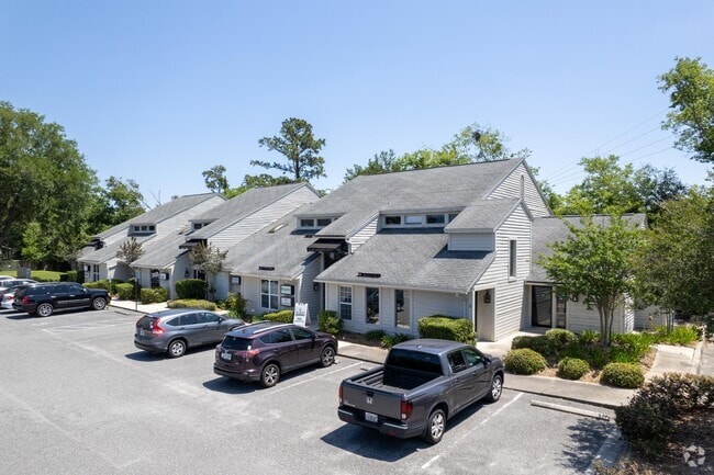
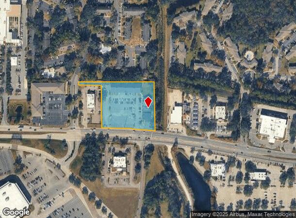
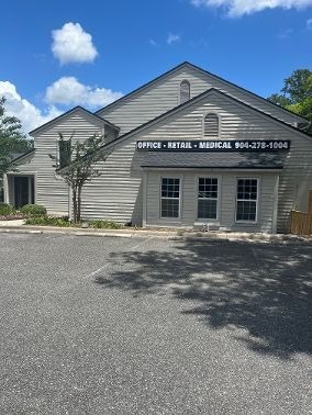
Property Record
1855 Wells Rd, Orange Park, FL 32073
NEARBY LISTINGS FOR SALE OR LEASE
Property Detail
1855 Wells Rd
05-04-26-010672-010-00
PT NW1/4 SEC 5 & PT NE1/4 SEC 6 OR 2782 PG 1381
Storesoffices
Clay
X
Florida
12031C0528J
2.82 AC
2024
Orange Park/Clay County
2025
Jacksonville (Florida)
030304
Jacksonville, FL
38,549 SF
DEMOGRAPHICS near 1855 Wells Rd
1 Mile
3 Mile
5 Mile
2024 Total Population
12,242
64,852
138,149
2029 Population
13,146
69,473
147,309
Pop Growth 2024-2029
+ 7.38%
+ 7.13%
+ 6.63%
Average Age
38
40
40
2024 Total Households
5,081
25,353
52,495
HH Growth 2024-2029
+ 7.44%
+ 7.25%
+ 6.75%
Median Household Inc
$53,710
$60,440
$65,050
Avg Household Size
2.30
2.40
2.50
2024 Avg HH Vehicles
2.00
2.00
2.00
Median Home Value
$174,320
$206,986
$219,312
Median Year Built
1985
1986
1986
Nearby Places
- Restaurants
- Banks
- Shops
- Fitness
- Groceries
PUBLIC TRANSPORTATION
AIRPORT
Jacksonville International
DRIVE
WALK
Distance
Jacksonville International
31 min
26.8 mi
Freight Ports
Jacksonville Port
DRIVE
WALK
Distance
Jacksonville Port
1 min
13.3 mi
SALE & LEASE HISTORY
LISTING DATE
SALE/LEASE

Sep 24, 2016
For Lease
Dec 09, 2016
For Lease
Nearby Properties
Address
Land Use
TOTAL SIZE
Lot Size
Zoning
Address
Land Use
TOTAL SIZE
Lot Size
Zoning
721,413 SF
46.72 AC
REBS
Address
Land Use
TOTAL SIZE
Lot Size
Zoning
446,722 SF
13.26 AC
PUD
Address
Land Use
TOTAL SIZE
Lot Size
Zoning
336,253 SF
30.19 AC
PUD
Address
Land Use
TOTAL SIZE
Lot Size
Zoning
270,088 SF
18.50 AC
PUD
Address
Land Use
TOTAL SIZE
Lot Size
Zoning
411,303 SF
26.71 AC
RMD-C
Address
Land Use
TOTAL SIZE
Lot Size
Zoning
250,798 SF
16.84 AC
PUD
Address
Land Use
TOTAL SIZE
Lot Size
Zoning
246,982 SF
24.84 AC
PUD
Address
Land Use
TOTAL SIZE
Lot Size
Zoning
238,713 SF
53.48 AC
BB
Address
Land Use
TOTAL SIZE
Lot Size
Zoning
227,234 SF
19.99 AC
RD-4
Address
Land Use
TOTAL SIZE
Lot Size
Zoning
281,440 SF
17.01 AC
Address
Land Use
TOTAL SIZE
Lot Size
Zoning
402,240 SF
20.66 AC
PUD
Address
Land Use
TOTAL SIZE
Lot Size
Zoning
355,124 SF
18.80 AC
PUD
Address
Land Use
TOTAL SIZE
Lot Size
Zoning
278,173 SF
27.85 AC
Address
Land Use
TOTAL SIZE
Lot Size
Zoning
296,311 SF
20.07 AC
Address
Land Use
TOTAL SIZE
Lot Size
Zoning
290,919 SF
18.75 AC
PUD
Address
Land Use
TOTAL SIZE
Lot Size
Zoning
380,002 SF
60.91 AC
RG-1
Address
Land Use
TOTAL SIZE
Lot Size
Zoning
277,912 SF
19.65 AC
Address
Land Use
TOTAL SIZE
Lot Size
Zoning
234,646 SF
18.97 AC
Address
Land Use
TOTAL SIZE
Lot Size
Zoning
348,247 SF
31.85 AC
PUD
Address
Land Use
TOTAL SIZE
Lot Size
Zoning
244,004 SF
24.97 AC
PUD
Address
Land Use
TOTAL SIZE
Lot Size
Zoning
281,174 SF
25.34 AC
PUD
Address
Land Use
TOTAL SIZE
Lot Size
Zoning
92,193 SF
20.65 AC
PUD
Address
Land Use
TOTAL SIZE
Lot Size
Zoning
33,237 SF
33.08 AC
Address
Land Use
TOTAL SIZE
Lot Size
Zoning
207,472 SF
13.39 AC
RD-4
Address
Land Use
TOTAL SIZE
Lot Size
Zoning
172,568 SF
13.15 AC
Address
Land Use
TOTAL SIZE
Lot Size
Zoning
228,290 SF
12.65 AC
RMD-D
Address
Land Use
TOTAL SIZE
Lot Size
Zoning
188,578 SF
13.44 AC
RMD-D
Address
Land Use
TOTAL SIZE
Lot Size
Zoning
207,571 SF
16.06 AC
PUD
Address
Land Use
TOTAL SIZE
Lot Size
Zoning
168,475 SF
9.38 AC
RD-4
Address
Land Use
TOTAL SIZE
Lot Size
Zoning
96,314 SF
21.05 AC
CCG-1
The World's #1 Commercial Real Estate Marketplace
Connect with us
© 2025 CoStar Group
The information above has been obtained from sources believed reliable. While we do not doubt its accuracy we have not verified it and make no guarantee, warranty or representation about it. It is your responsibility to independently confirm its accuracy and completeness. Any projections, opinions, assumptions, or estimates used are for example only and do not represent the current or future performance of the property. The value of this transaction to you depends on tax and other factors which should be evaluated by your tax, financial, and legal advisors. You and your advisors should conduct a careful, independent investigation of the property to determine to your satisfaction the suitability of the property for your needs.