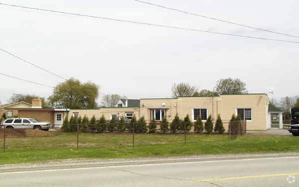
Property Record
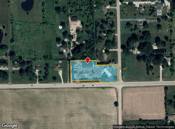
18575 32 Mile Rd, Armada, MI 48005
NEARBY LISTINGS FOR SALE OR LEASE
Property Detail
18575 32 Mile Rd
Detroit-Warren-Dearborn, MI
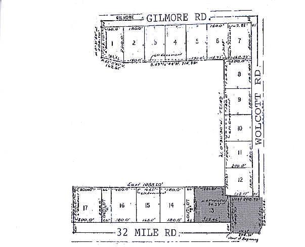
Rogala Subdivision
13-02-32-476-022
T5N,R13E SEC 32 BEG AT SE COR ARMADA AREA SCHOOLS
Storebuilding
Macomb
X
Michigan
26099C0140G
13
2025
2.16 AC
2025
St Clair & Lapeer Counties
212000
Detroit
3,390 SF
DEMOGRAPHICS near 18575 32 Mile Rd
1 mile
3 mile
5 mile
2024 Total Population
394
2,454
17,935
2029 Population
383
2,395
17,712
Pop Growth 2024-2029
(2.79%)
(2.40%)
(1.24%)
Average Age
45
44
43
2024 Total Households
149
912
6,766
HH Growth 2024-2029
(2.68%)
(2.41%)
(1.33%)
Median Household Inc
$103,788
$102,857
$88,625
Avg Household Size
2.60
2.70
2.60
2024 Avg HH Vehicles
3.00
3.00
2.00
Median Home Value
$369,736
$395,224
$321,888
Median Year Built
1975
1973
1978
Nearby Places
Map Layers
Map Styles
 Street
 Aerial
Transit
 Traffic
 Biking
Places
Listings with unknown addresses are not visible on the map
- Restaurants
- Banks
- Shops
- Fitness
- Groceries
Nearby Properties
Address
Land Use
TOTAL SIZE
Lot Size
Zoning
Address
Land Use
TOTAL SIZE
Lot Size
Zoning
1,937,172 SF
252.22 AC
IND VLG CK
Address
Land Use
TOTAL SIZE
Lot Size
Zoning
142,894 SF
IFT
Address
Land Use
TOTAL SIZE
Lot Size
Zoning
77,006 SF
12.52 AC
M-1
Address
Land Use
TOTAL SIZE
Lot Size
Zoning
49,800 SF
2.81 AC
IND VLG CK
Address
Land Use
TOTAL SIZE
Lot Size
Zoning
131,594 SF
4.90 AC
IND VLG CK
Address
Land Use
TOTAL SIZE
Lot Size
Zoning
75,808 SF
Address
Land Use
TOTAL SIZE
Lot Size
Zoning
79,775 SF
4.71 AC
M-1
Address
Land Use
TOTAL SIZE
Lot Size
Zoning
74,013 SF
4.41 AC
VERIFY
Address
Land Use
TOTAL SIZE
Lot Size
Zoning
80,000 SF
IFT
Address
Land Use
TOTAL SIZE
Lot Size
Zoning
106,097 SF
6.21 AC
IND VLG CK
Address
Land Use
TOTAL SIZE
Lot Size
Zoning
127,018 SF
4.50 AC
IND VLG CK
Address
Land Use
TOTAL SIZE
Lot Size
Zoning
71,874 SF
3.90 AC
IND VLG CK
Address
Land Use
TOTAL SIZE
Lot Size
Zoning
94,422 SF
24.90 AC
MI
Address
Land Use
TOTAL SIZE
Lot Size
Zoning
53,525 SF
IFT
Address
Land Use
TOTAL SIZE
Lot Size
Zoning
46,548 SF
40.49 AC
M-1
Address
Land Use
TOTAL SIZE
Lot Size
Zoning
45,089 SF
13.70 AC
MI
Address
Land Use
TOTAL SIZE
Lot Size
Zoning
58,636 SF
4.08 AC
IND VLG CK
Address
Land Use
TOTAL SIZE
Lot Size
Zoning
40,800 SF
Address
Land Use
TOTAL SIZE
Lot Size
Zoning
46,181 SF
2.61 AC
IND VLG CK
Address
Land Use
TOTAL SIZE
Lot Size
Zoning
33,780 SF
2.70 AC
IND VLG CK
Address
Land Use
TOTAL SIZE
Lot Size
Zoning
12,295 SF
7.45 AC
R-1
Address
Land Use
TOTAL SIZE
Lot Size
Zoning
2,036 SF
82.23 AC
IND
Address
Land Use
TOTAL SIZE
Lot Size
Zoning
26,000 SF
2.08 AC
M-1
Address
Land Use
TOTAL SIZE
Lot Size
Zoning
38,171 SF
1.99 AC
IND VLG CK
Address
Land Use
TOTAL SIZE
Lot Size
Zoning
37,939 SF
1.40 AC
IND VLG CK
Address
Land Use
TOTAL SIZE
Lot Size
Zoning
24,213 SF
2.30 AC
IND VLG CK
Address
Land Use
TOTAL SIZE
Lot Size
Zoning
55,708 SF
7.63 AC
MI
Address
Land Use
TOTAL SIZE
Lot Size
Zoning
60.66 AC
Address
Land Use
TOTAL SIZE
Lot Size
Zoning
50,909 SF
2.63 AC
IND VLG CK
Address
Land Use
TOTAL SIZE
Lot Size
Zoning
7,184 SF
5.61 AC
R-1
The World's #1 Commercial Real Estate Marketplace
Connect with us
© 2026 CoStar Group
The information above has been obtained from sources believed reliable. While we do not doubt its accuracy we have not verified it and make no guarantee, warranty or representation about it. It is your responsibility to independently confirm its accuracy and completeness. Any projections, opinions, assumptions, or estimates used are for example only and do not represent the current or future performance of the property. The value of this transaction to you depends on tax and other factors which should be evaluated by your tax, financial, and legal advisors. You and your advisors should conduct a careful, independent investigation of the property to determine to your satisfaction the suitability of the property for your needs.