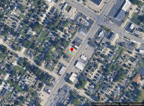
Property Record
18585 Allen Rd, Melvindale, MI 48122

NEARBY LISTINGS FOR SALE OR LEASE
Property Detail
18585 Allen Rd
Detroit-Warren-Dearborn, MI
Oakwood Heights
47-010-03-0080-001
CC80-CC83 LOTS 80 THRU 83 INCL OAKWOOD HEIGHTS SUB PC 35 L46 P19 WCR
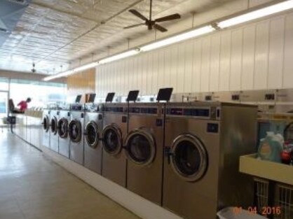
Laundromat
Wayne
X
Michigan
26163C0264E
80-83
0
0.18 AC
2025
Downriver North
578600
Detroit
3,200 SF
DEMOGRAPHICS near 18585 Allen Rd
1 Mile
3 Mile
5 Mile
2024 Total Population
12,291
101,256
311,101
2029 Population
11,746
97,461
299,813
Pop Growth 2024-2029
(4.43%)
(3.75%)
(3.63%)
Average Age
37
38
37
2024 Total Households
4,514
38,278
113,384
HH Growth 2024-2029
(4.45%)
(3.70%)
(3.63%)
Median Household Inc
$46,542
$52,166
$53,309
Avg Household Size
2.70
2.60
2.70
2024 Avg HH Vehicles
2.00
2.00
2.00
Median Home Value
$94,327
$130,581
$138,386
Median Year Built
1953
1953
1953
Nearby Places
Map Layers
Map Styles
 Street
 Aerial
- Restaurants
- Banks
- Shops
- Fitness
- Groceries
PUBLIC TRANSPORTATION
COMMUTER RAIL
DRIVE
WALK
Distance
9 min
3.8 mi
DRIVE
WALK
Distance
16 min
9.9 mi
AIRPORT
Detroit Metro Wayne County
DRIVE
WALK
Distance
Detroit Metro Wayne County
22 min
13.2 mi
Windsor International
DRIVE
WALK
Distance
Windsor International
37 min
18.6 mi
Freight Ports
DRIVE
WALK
Distance
67 min
53.6 mi
Nearby Properties
Address
Land Use
TOTAL SIZE
Lot Size
Zoning
Address
Land Use
TOTAL SIZE
Lot Size
Zoning
5,597,761 SF
73.85 AC
IB
Address
Land Use
TOTAL SIZE
Lot Size
Zoning
830,075 SF
167.21 AC
BC
Address
Land Use
TOTAL SIZE
Lot Size
Zoning
590,116 SF
388.80 AC
ID
Address
Land Use
TOTAL SIZE
Lot Size
Zoning
373,209 SF
349 AC
IC
Address
Land Use
TOTAL SIZE
Lot Size
Zoning
675,440 SF
66.32 AC
IB
Address
Land Use
TOTAL SIZE
Lot Size
Zoning
1,209,711 SF
69.44 AC
IB
Address
Land Use
TOTAL SIZE
Lot Size
Zoning
590,893 SF
51.81 AC
IB
Address
Land Use
TOTAL SIZE
Lot Size
Zoning
229,368 SF
1 AC
C 6A
Address
Land Use
TOTAL SIZE
Lot Size
Zoning
153,040 SF
2.13 AC
BC
Address
Land Use
TOTAL SIZE
Lot Size
Zoning
304,206 SF
29.53 AC
RC
Address
Land Use
TOTAL SIZE
Lot Size
Zoning
2,822,007 SF
75.54 AC
ID
Address
Land Use
TOTAL SIZE
Lot Size
Zoning
357,640 SF
13.89 AC
C 6C
Address
Land Use
TOTAL SIZE
Lot Size
Zoning
349,045 SF
40.28 AC
IB
Address
Land Use
TOTAL SIZE
Lot Size
Zoning
78,450 SF
12.03 AC
BC
Address
Land Use
TOTAL SIZE
Lot Size
Zoning
135,775 SF
18.39 AC
BC
Address
Land Use
TOTAL SIZE
Lot Size
Zoning
1,076,924 SF
125.54 AC
ID
Address
Land Use
TOTAL SIZE
Lot Size
Zoning
108,960 SF
5.23 AC
OS
Address
Land Use
TOTAL SIZE
Lot Size
Zoning
678,368 SF
48.99 AC
RD RESEARC
Address
Land Use
TOTAL SIZE
Lot Size
Zoning
219,434 SF
23.91 AC
BC
Address
Land Use
TOTAL SIZE
Lot Size
Zoning
102,646 SF
77.55 AC
ID
Address
Land Use
TOTAL SIZE
Lot Size
Zoning
198,237 SF
11.07 AC
RE
Address
Land Use
TOTAL SIZE
Lot Size
Zoning
Address
Land Use
TOTAL SIZE
Lot Size
Zoning
107,772 SF
8 AC
BC
Address
Land Use
TOTAL SIZE
Lot Size
Zoning
32,608 SF
46.51 AC
BC
Address
Land Use
TOTAL SIZE
Lot Size
Zoning
80,861 SF
1.17 AC
BC
Address
Land Use
TOTAL SIZE
Lot Size
Zoning
810,000 SF
23.15 AC
BC
Address
Land Use
TOTAL SIZE
Lot Size
Zoning
77,974 SF
1 AC
C 6A
Address
Land Use
TOTAL SIZE
Lot Size
Zoning
111,008 SF
26.62 AC
IB
Address
Land Use
TOTAL SIZE
Lot Size
Zoning
205,632 SF
1 AC
C 6A
Address
Land Use
TOTAL SIZE
Lot Size
Zoning
169,200 SF
19.92 AC
RD RESEARC
The World's #1 Commercial Real Estate Marketplace
Connect with us
© 2025 CoStar Group
The information above has been obtained from sources believed reliable. While we do not doubt its accuracy we have not verified it and make no guarantee, warranty or representation about it. It is your responsibility to independently confirm its accuracy and completeness. Any projections, opinions, assumptions, or estimates used are for example only and do not represent the current or future performance of the property. The value of this transaction to you depends on tax and other factors which should be evaluated by your tax, financial, and legal advisors. You and your advisors should conduct a careful, independent investigation of the property to determine to your satisfaction the suitability of the property for your needs.