Property Record
18585 Dale St, Detroit, MI 48219
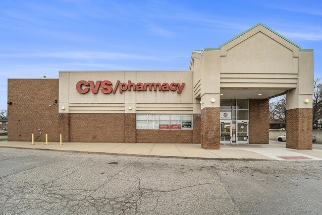

This Property Is For Sale
NEARBY LISTINGS FOR SALE OR LEASE
Property Detail
18585 Dale St
22-12228-692
Bungalohill
Drugstorepharmacycvswalgreens
W DALE 312 THRU 317 BUNGALOHILL SUB L35 P61 PLATS W C R 22/372 70 THRU 77 & VAC ALLEY ADJ SUPERVISORS STATE SUB NO 2 L58 P71
X
Wayne
26163C0067E
Michigan
2025
1.17 AC
2025
Detroit W of Woodward
541400
Detroit
10,987 SF
Detroit-Warren-Dearborn, MI
DEMOGRAPHICS near 18585 Dale St
1 Mile
3 Mile
5 Mile
2024 Total Population
14,107
105,761
289,587
2029 Population
13,604
103,043
282,404
Pop Growth 2024-2029
(3.57%)
(2.57%)
(2.48%)
Average Age
39
39
41
2024 Total Households
5,956
43,033
118,600
HH Growth 2024-2029
(3.84%)
(2.67%)
(2.52%)
Median Household Inc
$40,186
$48,611
$53,085
Avg Household Size
2.30
2.40
2.40
2024 Avg HH Vehicles
1.00
2.00
2.00
Median Home Value
$84,683
$112,221
$140,553
Median Year Built
1954
1954
1956
Nearby Places
Map Layers
Map Styles
 Street
 Aerial
- Restaurants
- Banks
- Shops
- Fitness
- Groceries
PUBLIC TRANSPORTATION
AIRPORT
Detroit Metro Wayne County
DRIVE
WALK
Distance
Detroit Metro Wayne County
35 min
19.3 mi
Windsor International
DRIVE
WALK
Distance
Windsor International
45 min
27.0 mi
Nearby Properties
Address
Land Use
TOTAL SIZE
Lot Size
Zoning
Address
Land Use
TOTAL SIZE
Lot Size
Zoning
383,602 SF
36.60 AC
I-1
Address
Land Use
TOTAL SIZE
Lot Size
Zoning
397,200 SF
14.07 AC
RMU
Address
Land Use
TOTAL SIZE
Lot Size
Zoning
174 SF
14.17 AC
RM
Address
Land Use
TOTAL SIZE
Lot Size
Zoning
204 SF
11.31 AC
RM
Address
Land Use
TOTAL SIZE
Lot Size
Zoning
202,736 SF
20 AC
PD
Address
Land Use
TOTAL SIZE
Lot Size
Zoning
143,700 SF
3.27 AC
PD
Address
Land Use
TOTAL SIZE
Lot Size
Zoning
158,092 SF
11.75 AC
B-3
Address
Land Use
TOTAL SIZE
Lot Size
Zoning
129 SF
15.16 AC
RM
Address
Land Use
TOTAL SIZE
Lot Size
Zoning
164,964 SF
14.96 AC
R-7
Address
Land Use
TOTAL SIZE
Lot Size
Zoning
152 SF
7.32 AC
RM
Address
Land Use
TOTAL SIZE
Lot Size
Zoning
143,941 SF
11.66 AC
PD
Address
Land Use
TOTAL SIZE
Lot Size
Zoning
167,562 SF
9.25 AC
R5
Address
Land Use
TOTAL SIZE
Lot Size
Zoning
16.05 AC
I-1
Address
Land Use
TOTAL SIZE
Lot Size
Zoning
129,975 SF
6.89 AC
R5
Address
Land Use
TOTAL SIZE
Lot Size
Zoning
115,270 SF
7.07 AC
AI
Address
Land Use
TOTAL SIZE
Lot Size
Zoning
104,567 SF
2.14 AC
PD
Address
Land Use
TOTAL SIZE
Lot Size
Zoning
96 SF
5.46 AC
RM
Address
Land Use
TOTAL SIZE
Lot Size
Zoning
104 SF
8.93 AC
RM
Address
Land Use
TOTAL SIZE
Lot Size
Zoning
18.17 AC
I-L
Address
Land Use
TOTAL SIZE
Lot Size
Zoning
186.50 AC
IND
Address
Land Use
TOTAL SIZE
Lot Size
Zoning
133,729 SF
5.95 AC
I-1
Address
Land Use
TOTAL SIZE
Lot Size
Zoning
137,658 SF
18.37 AC
I-L
Address
Land Use
TOTAL SIZE
Lot Size
Zoning
99,154 SF
7.04 AC
AI
Address
Land Use
TOTAL SIZE
Lot Size
Zoning
79,340 SF
3.20 AC
PD
Address
Land Use
TOTAL SIZE
Lot Size
Zoning
65,576 SF
7.84 AC
B3
Address
Land Use
TOTAL SIZE
Lot Size
Zoning
46,627 SF
5.26 AC
I-1
Address
Land Use
TOTAL SIZE
Lot Size
Zoning
110,242 SF
4.75 AC
Address
Land Use
TOTAL SIZE
Lot Size
Zoning
69 SF
6 AC
RM
Address
Land Use
TOTAL SIZE
Lot Size
Zoning
52,854 SF
7.50 AC
C-2
Address
Land Use
TOTAL SIZE
Lot Size
Zoning
58,586 SF
5.62 AC
The World's #1 Commercial Real Estate Marketplace
Connect with us
© 2026 CoStar Group
The information above has been obtained from sources believed reliable. While we do not doubt its accuracy we have not verified it and make no guarantee, warranty or representation about it. It is your responsibility to independently confirm its accuracy and completeness. Any projections, opinions, assumptions, or estimates used are for example only and do not represent the current or future performance of the property. The value of this transaction to you depends on tax and other factors which should be evaluated by your tax, financial, and legal advisors. You and your advisors should conduct a careful, independent investigation of the property to determine to your satisfaction the suitability of the property for your needs.