Property Record
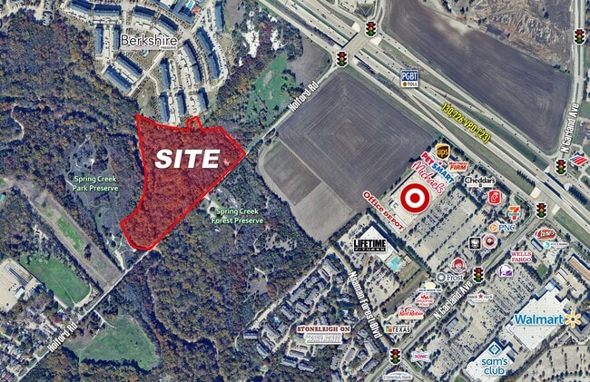
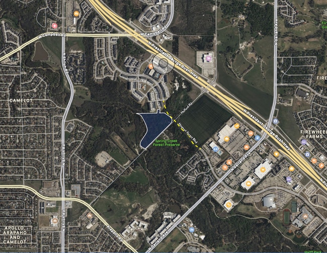
1859 Holford Rd, Garland, TX 75044

This Property Is For Sale
NEARBY LISTINGS FOR SALE OR LEASE
-
-
-
-
-
NEQ President George Bush Turnpike & N Garland Ave
Garland, TX 75044
Rent Upon Request
1.22 AC Lots
Land
-
-
-
View all Garland listings for sale on LoopNet.com
Property Detail
1859 Holford Rd
Dallas-Fort Worth-Arlington, TX
Thomas Montgomery
65096214510070200
THOMAS MONTGOMERY ABST 962 PG 145 TR 7.2 ACS 26.8496 VOL90211/2766 DD06221990 CO-DC 0962145100702 2CG09621451
Commercialacreage
Dallas
AE
Texas
48113C0210L
26.85 AC
0
Richardson
2025
Dallas/Ft Worth
019042
DEMOGRAPHICS near 1859 Holford Rd
1 Mile
3 Mile
5 Mile
2024 Total Population
11,014
110,319
320,821
2029 Population
11,510
115,204
340,270
Pop Growth 2024-2029
+ 4.50%
+ 4.43%
+ 6.06%
Average Age
37
41
39
2024 Total Households
4,704
40,274
114,438
HH Growth 2024-2029
+ 4.85%
+ 4.60%
+ 6.37%
Median Household Inc
$80,885
$96,512
$89,885
Avg Household Size
2.30
2.70
2.70
2024 Avg HH Vehicles
2.00
2.00
2.00
Median Home Value
$312,128
$361,203
$358,356
Median Year Built
2009
1986
1986
Nearby Places
Map Layers
Map Styles
 Street
 Aerial
- Restaurants
- Banks
- Shops
- Fitness
- Groceries
PUBLIC TRANSPORTATION
AIRPORT
Dallas Love Field
DRIVE
WALK
Distance
Dallas Love Field
31 min
20.0 mi
Dallas-Fort Worth International
DRIVE
WALK
Distance
Dallas-Fort Worth International
39 min
28.9 mi
Freight Ports
Port of Shreveport
DRIVE
WALK
Distance
Port of Shreveport
219 min
199.2 mi
Nearby Properties
Address
Land Use
TOTAL SIZE
Lot Size
Zoning
Address
Land Use
TOTAL SIZE
Lot Size
Zoning
479,209 SF
19.97 AC
Address
Land Use
TOTAL SIZE
Lot Size
Zoning
630,247 SF
42 AC
Z239
Address
Land Use
TOTAL SIZE
Lot Size
Zoning
766,245 SF
49.94 AC
COMM
Address
Land Use
TOTAL SIZE
Lot Size
Zoning
164,843 SF
24.94 AC
Address
Land Use
TOTAL SIZE
Lot Size
Zoning
242,201 SF
14.54 AC
RT
Address
Land Use
TOTAL SIZE
Lot Size
Zoning
768,061 SF
42.03 AC
Z02
Address
Land Use
TOTAL SIZE
Lot Size
Zoning
650,164 SF
66.57 AC
Z02
Address
Land Use
TOTAL SIZE
Lot Size
Zoning
279,693 SF
19.86 AC
Z239
Address
Land Use
TOTAL SIZE
Lot Size
Zoning
548,300 SF
17.29 AC
Z239
Address
Land Use
TOTAL SIZE
Lot Size
Zoning
129,810 SF
14.93 AC
Z236
Address
Land Use
TOTAL SIZE
Lot Size
Zoning
374,266 SF
19.42 AC
Z239
Address
Land Use
TOTAL SIZE
Lot Size
Zoning
360,673 SF
7.89 AC
PD-207 R
Address
Land Use
TOTAL SIZE
Lot Size
Zoning
353,347 SF
17 AC
Z02
Address
Land Use
TOTAL SIZE
Lot Size
Zoning
426,467 SF
24.12 AC
Z142
Address
Land Use
TOTAL SIZE
Lot Size
Zoning
433,745 SF
15.18 AC
Z02
Address
Land Use
TOTAL SIZE
Lot Size
Zoning
450,481 SF
10.73 AC
PD-207 R
Address
Land Use
TOTAL SIZE
Lot Size
Zoning
137,772 SF
11.79 AC
LC/PD-A
Address
Land Use
TOTAL SIZE
Lot Size
Zoning
829,390 SF
66.56 AC
1-M-1
Address
Land Use
TOTAL SIZE
Lot Size
Zoning
287,833 SF
9.81 AC
PD-207 R
Address
Land Use
TOTAL SIZE
Lot Size
Zoning
181,200 SF
15.11 AC
Address
Land Use
TOTAL SIZE
Lot Size
Zoning
388,059 SF
21.80 AC
Z239
Address
Land Use
TOTAL SIZE
Lot Size
Zoning
365,761 SF
22.88 AC
COMM
Address
Land Use
TOTAL SIZE
Lot Size
Zoning
342,658 SF
4.94 AC
Z239
Address
Land Use
TOTAL SIZE
Lot Size
Zoning
241,478 SF
7.86 AC
PD-207 R
Address
Land Use
TOTAL SIZE
Lot Size
Zoning
244,025 SF
17.80 AC
Z02
Address
Land Use
TOTAL SIZE
Lot Size
Zoning
303,169 SF
19.67 AC
Z239
Address
Land Use
TOTAL SIZE
Lot Size
Zoning
403,206 SF
4 AC
Z239
Address
Land Use
TOTAL SIZE
Lot Size
Zoning
276,236 SF
8.96 AC
Z239
Address
Land Use
TOTAL SIZE
Lot Size
Zoning
107,686 SF
30.09 AC
Z386
Address
Land Use
TOTAL SIZE
Lot Size
Zoning
280,598 SF
7.36 AC
Z239
The World's #1 Commercial Real Estate Marketplace
Connect with us
© 2026 CoStar Group
The information above has been obtained from sources believed reliable. While we do not doubt its accuracy we have not verified it and make no guarantee, warranty or representation about it. It is your responsibility to independently confirm its accuracy and completeness. Any projections, opinions, assumptions, or estimates used are for example only and do not represent the current or future performance of the property. The value of this transaction to you depends on tax and other factors which should be evaluated by your tax, financial, and legal advisors. You and your advisors should conduct a careful, independent investigation of the property to determine to your satisfaction the suitability of the property for your needs.