Property Record
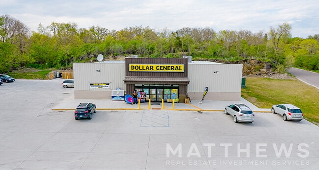
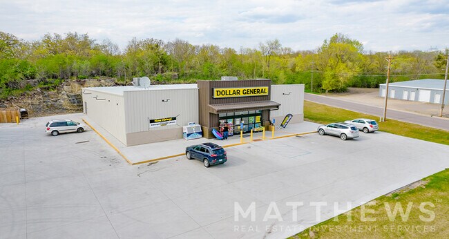
186 Highway 212 E, Granite Falls, MN 56241


Property Detail
186 Highway 212 E
40-934-3330
A TRACT IN GOVT LOT 4 DESC AS BEG AT A POINT ON S LINE BLOCK 4 PILLSBURYS 4TH ADD 187.6 FT NELY FROM SW COR OF LOT 9 BLOCK 4
Commercialnec
Chippewa
B and X Area of moderate flood hazard, usually the area between the limits of the 100-year and 500-year floods.
Minnesota
2026
1,9
2025
0.93 AC
950300
Minnesota South Area
7,435 SF
Other Market Areas
NEARBY LISTINGS FOR SALE OR LEASE
-
-
View all Granite Falls listings for sale on LoopNet.com
DEMOGRAPHICS near 186 Highway 212 E
1 mile
3 mile
5 mile
2025 Total Population
2,309
3,123
3,577
2030 Population
2,305
3,118
3,559
Pop Growth 2025-2030
(0.17%)
(0.16%)
(0.50%)
Average Age
44
43
43
2025 Total Households
1,044
1,388
1,575
HH Growth 2025-2030
(0.38%)
(0.29%)
(0.57%)
Median Household Inc
$65,546
$67,445
$69,577
Avg Household Size
2.10
2.10
2.20
2025 Avg HH Vehicles
2.00
2.00
2.00
Median Home Value
$162,448
$167,876
$169,306
Median Year Built
1966
1968
1967
Nearby Places
Map Layers
Map Styles
 Street
 Aerial
Layers
 Traffic
 Biking
Places
Listings with unknown addresses are not visible on the map
- Restaurants
- Banks
- Shops
- Fitness
- Groceries
SALE & LEASE HISTORY
LISTING DATE
SALE/LEASE

May 27, 2021
For Sale
Jul 13, 2019
For Sale
Nearby Properties
Address
Land Use
TOTAL SIZE
Lot Size
Zoning
Address
Land Use
TOTAL SIZE
Lot Size
Zoning
Address
Land Use
TOTAL SIZE
Lot Size
Zoning
28.70 AC
Address
Land Use
TOTAL SIZE
Lot Size
Zoning
13.43 AC
Address
Land Use
TOTAL SIZE
Lot Size
Zoning
150.60 AC
Address
Land Use
TOTAL SIZE
Lot Size
Zoning
Address
Land Use
TOTAL SIZE
Lot Size
Zoning
0.88 AC
Address
Land Use
TOTAL SIZE
Lot Size
Zoning
Address
Land Use
TOTAL SIZE
Lot Size
Zoning
11,804 SF
5.09 AC
Address
Land Use
TOTAL SIZE
Lot Size
Zoning
Address
Land Use
TOTAL SIZE
Lot Size
Zoning
Address
Land Use
TOTAL SIZE
Lot Size
Zoning
Address
Land Use
TOTAL SIZE
Lot Size
Zoning
159.90 AC
Address
Land Use
TOTAL SIZE
Lot Size
Zoning
Address
Land Use
TOTAL SIZE
Lot Size
Zoning
Address
Land Use
TOTAL SIZE
Lot Size
Zoning
26,400 SF
10.73 AC
Address
Land Use
TOTAL SIZE
Lot Size
Zoning
5,698 SF
1.85 AC
Address
Land Use
TOTAL SIZE
Lot Size
Zoning
7,884 SF
1.26 AC
Address
Land Use
TOTAL SIZE
Lot Size
Zoning
82.99 AC
Address
Land Use
TOTAL SIZE
Lot Size
Zoning
Address
Land Use
TOTAL SIZE
Lot Size
Zoning
7,025 SF
0.28 AC
Address
Land Use
TOTAL SIZE
Lot Size
Zoning
71.15 AC
Address
Land Use
TOTAL SIZE
Lot Size
Zoning
1.22 AC
Address
Land Use
TOTAL SIZE
Lot Size
Zoning
Address
Land Use
TOTAL SIZE
Lot Size
Zoning
17,470 SF
0.47 AC
Address
Land Use
TOTAL SIZE
Lot Size
Zoning
7,791 SF
0.48 AC
Address
Land Use
TOTAL SIZE
Lot Size
Zoning
11,260 SF
6.33 AC
Address
Land Use
TOTAL SIZE
Lot Size
Zoning
4,954 SF
0.43 AC
Address
Land Use
TOTAL SIZE
Lot Size
Zoning
74.97 AC
Address
Land Use
TOTAL SIZE
Lot Size
Zoning
5,088 SF
0.26 AC
Address
Land Use
TOTAL SIZE
Lot Size
Zoning
The World's #1 Commercial Real Estate Marketplace
Connect with us
© 2026 CoStar Group
The information above has been obtained from sources believed reliable. While we do not doubt its accuracy we have not verified it and make no guarantee, warranty or representation about it. It is your responsibility to independently confirm its accuracy and completeness. Any projections, opinions, assumptions, or estimates used are for example only and do not represent the current or future performance of the property. The value of this transaction to you depends on tax and other factors which should be evaluated by your tax, financial, and legal advisors. You and your advisors should conduct a careful, independent investigation of the property to determine to your satisfaction the suitability of the property for your needs.