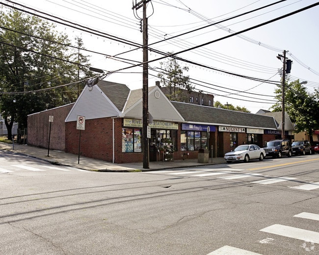
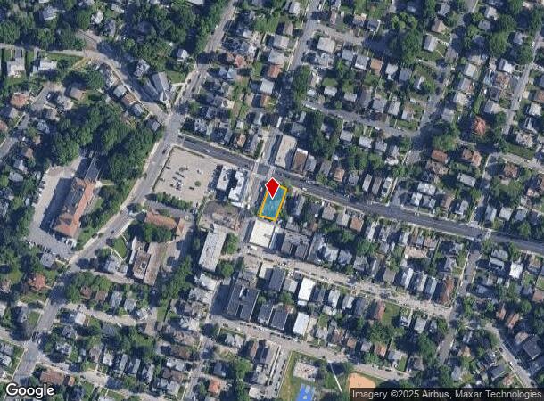
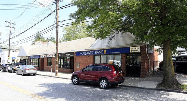
Property Record
186 Roberts Ave, Yonkers, NY 10703
NEARBY LISTINGS FOR SALE OR LEASE
Property Detail
186 Roberts Ave
1800-003-000-03039-000-0054
Westchester
Commercialofficeresidentialmixeduse
New York
X
54.000
34003C0210H
0.14 AC
2025
Southwest
2024
Westchester/So Connecticut
000803
New York-Jersey City-White Plains, NY-NJ
5,300 SF
DEMOGRAPHICS near 186 Roberts Ave
1 Mile
3 Mile
5 Mile
2024 Total Population
25,330
163,889
448,074
2029 Population
24,449
160,425
434,882
Pop Growth 2024-2029
(3.48%)
(2.11%)
(2.94%)
Average Age
42
41
41
2024 Total Households
9,846
61,485
167,387
HH Growth 2024-2029
(3.48%)
(2.23%)
(3.15%)
Median Household Inc
$90,513
$72,984
$89,010
Avg Household Size
2.50
2.50
2.50
2024 Avg HH Vehicles
1.00
1.00
1.00
Median Home Value
$412,593
$502,595
$601,684
Median Year Built
1958
1957
1953
Nearby Places
Map Layers
Map Styles
 Street
 Aerial
- Restaurants
- Banks
- Shops
- Fitness
- Groceries
PUBLIC TRANSPORTATION
COMMUTER RAIL
Greystone Station (Hudson Line - Metro-North Commuter Railroad Company (Metro-North))
DRIVE
WALK
Distance
Greystone Station (Hudson Line - Metro-North Commuter Railroad Company (Metro-North))
4 min
1.4 mi
Glenwood Station (Hudson Line - Metro-North Commuter Railroad Company (Metro-North))
DRIVE
WALK
Distance
Glenwood Station (Hudson Line - Metro-North Commuter Railroad Company (Metro-North))
4 min
1.5 mi
AIRPORT
LaGuardia
DRIVE
WALK
Distance
LaGuardia
28 min
19.5 mi
Westchester County
DRIVE
WALK
Distance
Westchester County
27 min
19.8 mi
John F Kennedy International
DRIVE
WALK
Distance
John F Kennedy International
39 min
27.4 mi
Freight Ports
NY - Red Hook Container Terminal
DRIVE
WALK
Distance
NY - Red Hook Container Terminal
36 min
25.3 mi
SALE & LEASE HISTORY
LISTING DATE
SALE/LEASE

Jun 27, 2022
For Lease
Aug 20, 2018
For Lease
Apr 16, 2023
For Sale
Nearby Properties
Address
Land Use
TOTAL SIZE
Lot Size
Zoning
Address
Land Use
TOTAL SIZE
Lot Size
Zoning
1,125 SF
542.62 AC
RA
Address
Land Use
TOTAL SIZE
Lot Size
Zoning
689 SF
423.72 AC
P
Address
Land Use
TOTAL SIZE
Lot Size
Zoning
289.02 AC
P
Address
Land Use
TOTAL SIZE
Lot Size
Zoning
201,590 SF
4.13 AC
BA
Address
Land Use
TOTAL SIZE
Lot Size
Zoning
229.55 AC
P
Address
Land Use
TOTAL SIZE
Lot Size
Zoning
185.35 AC
P
Address
Land Use
TOTAL SIZE
Lot Size
Zoning
70,737 SF
1.67 AC
BB
Address
Land Use
TOTAL SIZE
Lot Size
Zoning
166.61 AC
P
Address
Land Use
TOTAL SIZE
Lot Size
Zoning
23.97 AC
Address
Land Use
TOTAL SIZE
Lot Size
Zoning
68,911 SF
16.31 AC
Address
Land Use
TOTAL SIZE
Lot Size
Zoning
94.42 AC
P
Address
Land Use
TOTAL SIZE
Lot Size
Zoning
Address
Land Use
TOTAL SIZE
Lot Size
Zoning
Address
Land Use
TOTAL SIZE
Lot Size
Zoning
54.65 AC
P
Address
Land Use
TOTAL SIZE
Lot Size
Zoning
28.77 AC
Address
Land Use
TOTAL SIZE
Lot Size
Zoning
47.14 AC
P
Address
Land Use
TOTAL SIZE
Lot Size
Zoning
41.23 AC
P
Address
Land Use
TOTAL SIZE
Lot Size
Zoning
13.35 AC
Address
Land Use
TOTAL SIZE
Lot Size
Zoning
11.70 AC
R-30
Address
Land Use
TOTAL SIZE
Lot Size
Zoning
Address
Land Use
TOTAL SIZE
Lot Size
Zoning
30.29 AC
P
Address
Land Use
TOTAL SIZE
Lot Size
Zoning
69.90 AC
R-20
Address
Land Use
TOTAL SIZE
Lot Size
Zoning
25.58 AC
P
Address
Land Use
TOTAL SIZE
Lot Size
Zoning
25 AC
P
Address
Land Use
TOTAL SIZE
Lot Size
Zoning
122.38 AC
R-30
Address
Land Use
TOTAL SIZE
Lot Size
Zoning
36,413 SF
0.89 AC
A
Address
Land Use
TOTAL SIZE
Lot Size
Zoning
34,560 SF
0.28 AC
BA
Address
Land Use
TOTAL SIZE
Lot Size
Zoning
23,116 SF
1.82 AC
C
Address
Land Use
TOTAL SIZE
Lot Size
Zoning
4.85 AC
GI
Address
Land Use
TOTAL SIZE
Lot Size
Zoning
18.57 AC
P
The World's #1 Commercial Real Estate Marketplace
Connect with us
© 2025 CoStar Group
The information above has been obtained from sources believed reliable. While we do not doubt its accuracy we have not verified it and make no guarantee, warranty or representation about it. It is your responsibility to independently confirm its accuracy and completeness. Any projections, opinions, assumptions, or estimates used are for example only and do not represent the current or future performance of the property. The value of this transaction to you depends on tax and other factors which should be evaluated by your tax, financial, and legal advisors. You and your advisors should conduct a careful, independent investigation of the property to determine to your satisfaction the suitability of the property for your needs.