Property Record
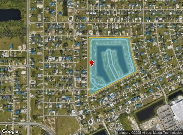
186 Tierra De Paz Loop, Cape Coral, FL 33993


NEARBY LISTINGS FOR SALE OR LEASE
Property Detail
186 Tierra De Paz Loop
Cape Coral-Fort Myers, FL
Cape Coral
11-44-23-C4-02580.0000
CAPE CORAL UNIT 37 BLK 2580 PB 17 PG 17 ALL OF BLK 2580
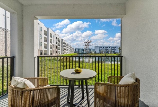
Multifamilydwelling
Lee
X
Florida
12071C0263G
25.99 AC
2024
Mariner
2025
Southwest Florida
010205
DEMOGRAPHICS near 186 Tierra De Paz Loop
1 Mile
3 Mile
5 Mile
2024 Total Population
5,981
66,341
158,927
2029 Population
7,313
78,821
188,663
Pop Growth 2024-2029
+ 22.27%
+ 18.81%
+ 18.71%
Average Age
38
40
41
2024 Total Households
1,990
23,119
58,273
HH Growth 2024-2029
+ 21.76%
+ 18.21%
+ 18.15%
Median Household Inc
$66,689
$65,353
$67,667
Avg Household Size
2.90
2.70
2.60
2024 Avg HH Vehicles
2.00
2.00
2.00
Median Home Value
$229,815
$255,411
$269,863
Median Year Built
2006
2002
2001
Nearby Places
Map Layers
Map Styles
 Street
 Aerial
- Restaurants
- Banks
- Shops
- Fitness
- Groceries
PUBLIC TRANSPORTATION
AIRPORT
Southwest Florida International
DRIVE
WALK
Distance
Southwest Florida International
39 min
23.3 mi
Punta Gorda
DRIVE
WALK
Distance
Punta Gorda
39 min
23.8 mi
Freight Ports
Port Manatee
DRIVE
WALK
Distance
Port Manatee
119 min
97.7 mi
Nearby Properties
Address
Land Use
TOTAL SIZE
Lot Size
Zoning
Address
Land Use
TOTAL SIZE
Lot Size
Zoning
634,872 SF
43.30 AC
C1-D
Address
Land Use
TOTAL SIZE
Lot Size
Zoning
476,419 SF
36.49 AC
C1
Address
Land Use
TOTAL SIZE
Lot Size
Zoning
507,243 SF
115.38 AC
A
Address
Land Use
TOTAL SIZE
Lot Size
Zoning
231,454 SF
14.53 AC
CC
Address
Land Use
TOTAL SIZE
Lot Size
Zoning
339,525 SF
38.30 AC
R1BD
Address
Land Use
TOTAL SIZE
Lot Size
Zoning
7.82 AC
CORR
Address
Land Use
TOTAL SIZE
Lot Size
Zoning
101,204 SF
12.34 AC
P1-D
Address
Land Use
TOTAL SIZE
Lot Size
Zoning
27.77 AC
RML
Address
Land Use
TOTAL SIZE
Lot Size
Zoning
101,999 SF
7.17 AC
P-1
Address
Land Use
TOTAL SIZE
Lot Size
Zoning
83,035 SF
19.01 AC
CORR
Address
Land Use
TOTAL SIZE
Lot Size
Zoning
153,651 SF
17.17 AC
R1-B
Address
Land Use
TOTAL SIZE
Lot Size
Zoning
147,599 SF
5.72 AC
RML
Address
Land Use
TOTAL SIZE
Lot Size
Zoning
142,379 SF
3.27 AC
Address
Land Use
TOTAL SIZE
Lot Size
Zoning
62,119 SF
6.50 AC
CORR
Address
Land Use
TOTAL SIZE
Lot Size
Zoning
71,898 SF
98.60 AC
C1-D
Address
Land Use
TOTAL SIZE
Lot Size
Zoning
101,110 SF
8.67 AC
VILL
Address
Land Use
TOTAL SIZE
Lot Size
Zoning
78,298 SF
12.73 AC
CORR
Address
Land Use
TOTAL SIZE
Lot Size
Zoning
102,818 SF
8.60 AC
CORR
Address
Land Use
TOTAL SIZE
Lot Size
Zoning
19,218 SF
3.79 AC
CC
Address
Land Use
TOTAL SIZE
Lot Size
Zoning
79,062 SF
5.15 AC
CORR
Address
Land Use
TOTAL SIZE
Lot Size
Zoning
100,325 SF
4.86 AC
C-1
Address
Land Use
TOTAL SIZE
Lot Size
Zoning
56,092 SF
4.52 AC
CORR
Address
Land Use
TOTAL SIZE
Lot Size
Zoning
53,979 SF
3.24 AC
P-1
Address
Land Use
TOTAL SIZE
Lot Size
Zoning
12,252 SF
12.37 AC
CC
Address
Land Use
TOTAL SIZE
Lot Size
Zoning
154,947 SF
13.83 AC
CORR
Address
Land Use
TOTAL SIZE
Lot Size
Zoning
52,459 SF
9.22 AC
C-1
Address
Land Use
TOTAL SIZE
Lot Size
Zoning
84,278 SF
5 AC
CORR
Address
Land Use
TOTAL SIZE
Lot Size
Zoning
291,158 SF
25.64 AC
INS
Address
Land Use
TOTAL SIZE
Lot Size
Zoning
57,758 SF
4.45 AC
CORR
The World's #1 Commercial Real Estate Marketplace
Connect with us
© 2026 CoStar Group
The information above has been obtained from sources believed reliable. While we do not doubt its accuracy we have not verified it and make no guarantee, warranty or representation about it. It is your responsibility to independently confirm its accuracy and completeness. Any projections, opinions, assumptions, or estimates used are for example only and do not represent the current or future performance of the property. The value of this transaction to you depends on tax and other factors which should be evaluated by your tax, financial, and legal advisors. You and your advisors should conduct a careful, independent investigation of the property to determine to your satisfaction the suitability of the property for your needs.