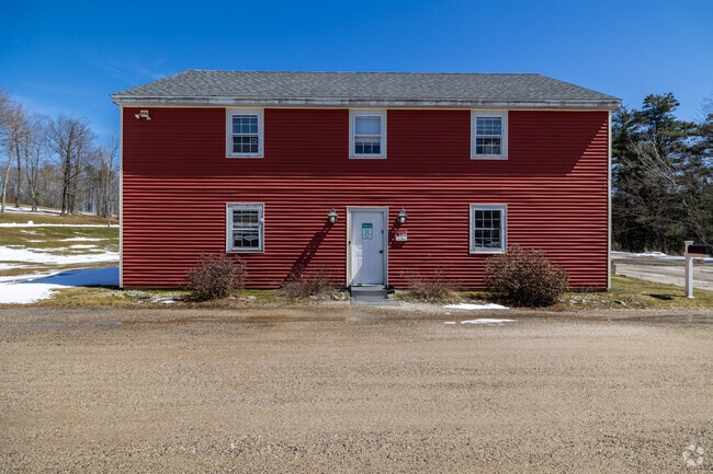
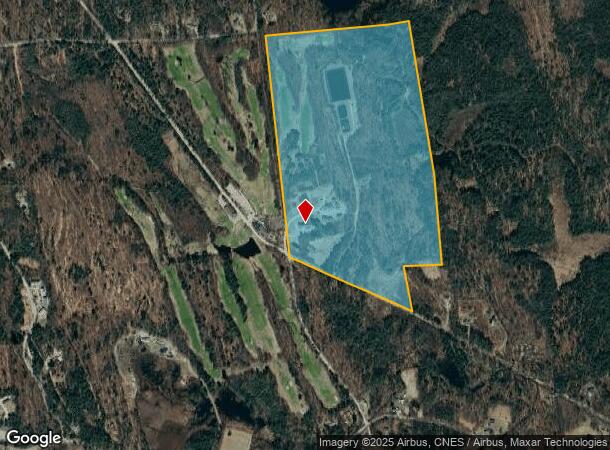
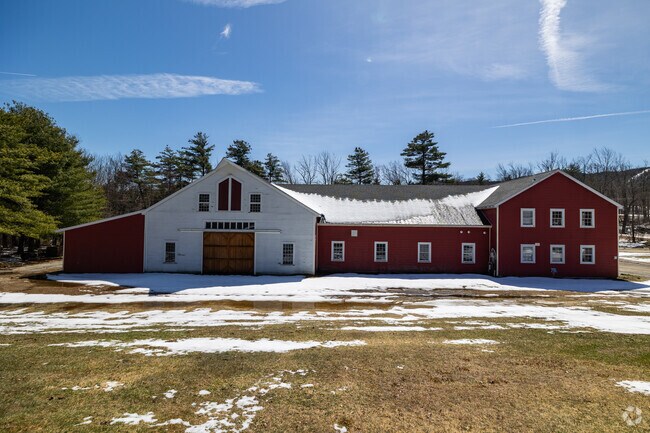
Property Record
186 Tory Pines Rd, Francestown, NH 03043
NEARBY LISTINGS FOR SALE OR LEASE
-
-
View all Francestown listings for sale on LoopNet.com
Property Detail
186 Tory Pines Rd
FRNT-000008-000000-000044
Hillsborough
Commercialnec
New Hampshire
A
44
33011C0165D
124 AC
2024
Outer Hillsborough County
2024
Boston
021500
Manchester-Nashua, NH
8,192 SF
DEMOGRAPHICS near 186 Tory Pines Rd
1 Mile
3 Mile
5 Mile
2024 Total Population
316
1,701
6,029
2029 Population
322
1,732
6,109
Pop Growth 2024-2029
+ 1.90%
+ 1.82%
+ 1.33%
Average Age
44
44
44
2024 Total Households
129
710
2,442
HH Growth 2024-2029
+ 2.33%
+ 1.69%
+ 1.31%
Median Household Inc
$80,263
$74,290
$79,202
Avg Household Size
2.50
2.40
2.40
2024 Avg HH Vehicles
2.00
2.00
2.00
Median Home Value
$296,551
$286,423
$297,249
Median Year Built
1974
1974
1973
Nearby Places
Map Layers
Map Styles
 Street
 Aerial
- Restaurants
- Banks
- Shops
- Fitness
- Groceries
PUBLIC TRANSPORTATION
AIRPORT
Manchester Boston Regional
DRIVE
WALK
Distance
Manchester Boston Regional
64 min
30.7 mi
Freight Ports
Port of Boston
DRIVE
WALK
Distance
Port of Boston
126 min
77.7 mi
SALE & LEASE HISTORY
LISTING DATE
SALE/LEASE

Dec 29, 2023
For Sale
Nearby Properties
Address
Land Use
TOTAL SIZE
Lot Size
Zoning
Address
Land Use
TOTAL SIZE
Lot Size
Zoning
42,788 SF
10 AC
CR C
Address
Land Use
TOTAL SIZE
Lot Size
Zoning
17 AC
RURAL
Address
Land Use
TOTAL SIZE
Lot Size
Zoning
9,138 SF
27.53 AC
RURAL
Address
Land Use
TOTAL SIZE
Lot Size
Zoning
13.20 AC
RURAL
Address
Land Use
TOTAL SIZE
Lot Size
Zoning
26.80 AC
RURAL
Address
Land Use
TOTAL SIZE
Lot Size
Zoning
VIL V
Address
Land Use
TOTAL SIZE
Lot Size
Zoning
1 AC
RURAL
Address
Land Use
TOTAL SIZE
Lot Size
Zoning
2,713 SF
6.03 AC
RURAL
Address
Land Use
TOTAL SIZE
Lot Size
Zoning
8,995 SF
18.20 AC
RES
Address
Land Use
TOTAL SIZE
Lot Size
Zoning
2,114 SF
22 AC
RURAL
Address
Land Use
TOTAL SIZE
Lot Size
Zoning
9,621 SF
233 AC
RA R
Address
Land Use
TOTAL SIZE
Lot Size
Zoning
7,918 SF
3.72 AC
CR C
Address
Land Use
TOTAL SIZE
Lot Size
Zoning
Address
Land Use
TOTAL SIZE
Lot Size
Zoning
2,545 SF
5 AC
RURAL
Address
Land Use
TOTAL SIZE
Lot Size
Zoning
1,987 SF
78.90 AC
RA R
Address
Land Use
TOTAL SIZE
Lot Size
Zoning
2,197 SF
1 AC
RURAL
Address
Land Use
TOTAL SIZE
Lot Size
Zoning
Address
Land Use
TOTAL SIZE
Lot Size
Zoning
3,185 SF
12.18 AC
CR C
Address
Land Use
TOTAL SIZE
Lot Size
Zoning
1,762 SF
57.60 AC
WRP W
Address
Land Use
TOTAL SIZE
Lot Size
Zoning
3,146 SF
14.90 AC
RES
Address
Land Use
TOTAL SIZE
Lot Size
Zoning
3,125 SF
9.70 AC
RA R
Address
Land Use
TOTAL SIZE
Lot Size
Zoning
11.45 AC
RURAL
Address
Land Use
TOTAL SIZE
Lot Size
Zoning
1,517 SF
3.95 AC
RA R
Address
Land Use
TOTAL SIZE
Lot Size
Zoning
11.80 AC
RURAL
Address
Land Use
TOTAL SIZE
Lot Size
Zoning
1,477 SF
1.90 AC
RES
Address
Land Use
TOTAL SIZE
Lot Size
Zoning
2,485 SF
4.49 AC
RES
Address
Land Use
TOTAL SIZE
Lot Size
Zoning
4,508 SF
51.12 AC
CR C
Address
Land Use
TOTAL SIZE
Lot Size
Zoning
25.16 AC
CR C
Address
Land Use
TOTAL SIZE
Lot Size
Zoning
3,239 SF
3.20 AC
RA R
The World's #1 Commercial Real Estate Marketplace
Connect with us
© 2026 CoStar Group
The information above has been obtained from sources believed reliable. While we do not doubt its accuracy we have not verified it and make no guarantee, warranty or representation about it. It is your responsibility to independently confirm its accuracy and completeness. Any projections, opinions, assumptions, or estimates used are for example only and do not represent the current or future performance of the property. The value of this transaction to you depends on tax and other factors which should be evaluated by your tax, financial, and legal advisors. You and your advisors should conduct a careful, independent investigation of the property to determine to your satisfaction the suitability of the property for your needs.