Property Record
1860 E Oglethorpe Blvd, Albany, GA 31705

Property Detail
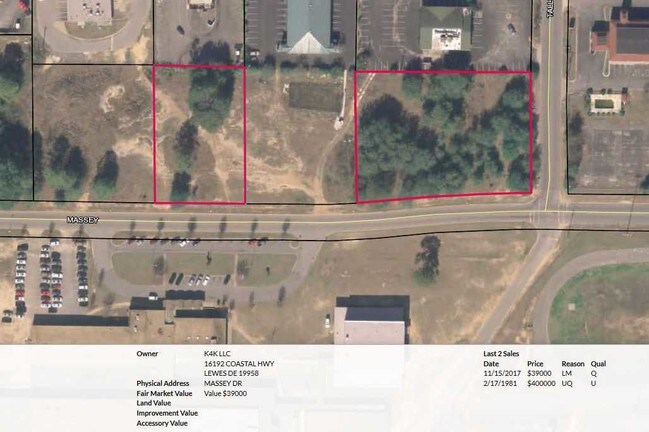
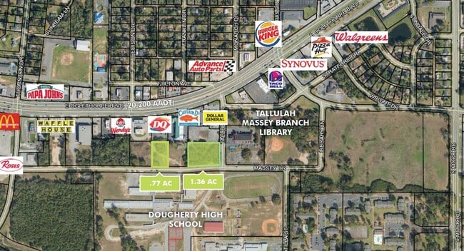
1860 E Oglethorpe Blvd
000II-00035-003
PRCL 1 GREEN CIRCLES FARM S/D
Commercialacreage
DOUGHERTY
C-3
Georgia
B and X Area of moderate flood hazard, usually the area between the limits of the 100-year and 500-year floods.
1.36 AC
2025
Albany/Southwest
2025
Other Market Areas
000101
Albany, GA
NEARBY LISTINGS FOR SALE OR LEASE
DEMOGRAPHICS near 1860 E Oglethorpe Blvd
1 mile
3 mile
5 mile
2025 Total Population
3,700
20,238
44,453
2030 Population
3,706
20,010
44,136
Pop Growth 2025-2030
+ 0.16%
(1.13%)
(0.71%)
Average Age
34
35
38
2025 Total Households
1,522
7,460
17,786
HH Growth 2025-2030
(0.33%)
(1.22%)
(0.72%)
Median Household Inc
$33,096
$29,313
$35,875
Avg Household Size
2.40
2.40
2.30
2025 Avg HH Vehicles
1.00
1.00
1.00
Median Home Value
$58,139
$77,324
$101,850
Median Year Built
1975
1972
1970
Nearby Places
Map Layers
Map Styles
 Street
 Aerial
Transit
 Traffic
 Biking
Places
Listings with unknown addresses are not visible on the map
- Restaurants
- Banks
- Shops
- Fitness
- Groceries
PUBLIC TRANSPORTATION
AIRPORT
Southwest Georgia Regional
Drive
Walk
Distance
Southwest Georgia Regional
18 min
8.5 mi
SALE & LEASE HISTORY
LISTING DATE
SALE/LEASE

Mar 31, 2021
For Sale
Jul 17, 2018
For Sale
Aug 01, 2020
For Sale
Nearby Properties
Address
Land Use
TOTAL SIZE
Lot Size
Zoning
Address
Land Use
TOTAL SIZE
Lot Size
Zoning
34,888 SF
164.47 AC
M-2
Address
Land Use
TOTAL SIZE
Lot Size
Zoning
243,722 SF
226.11 AC
M-2
Address
Land Use
TOTAL SIZE
Lot Size
Zoning
1,445,486 SF
108.05 AC
M1
Address
Land Use
TOTAL SIZE
Lot Size
Zoning
58.86 AC
C-3
Address
Land Use
TOTAL SIZE
Lot Size
Zoning
3,664 SF
1,672.02 AC
C-1
Address
Land Use
TOTAL SIZE
Lot Size
Zoning
15.20 AC
C-2
Address
Land Use
TOTAL SIZE
Lot Size
Zoning
2.53 AC
C-2
Address
Land Use
TOTAL SIZE
Lot Size
Zoning
1.75 AC
C-2
Address
Land Use
TOTAL SIZE
Lot Size
Zoning
2,100 SF
9.92 AC
M1
Address
Land Use
TOTAL SIZE
Lot Size
Zoning
50,000 SF
50.37 AC
C-3
Address
Land Use
TOTAL SIZE
Lot Size
Zoning
141,600 SF
45.43 AC
C-1
Address
Land Use
TOTAL SIZE
Lot Size
Zoning
288,982 SF
39.52 AC
M-1
Address
Land Use
TOTAL SIZE
Lot Size
Zoning
77,688 SF
2.93 AC
C-3
Address
Land Use
TOTAL SIZE
Lot Size
Zoning
653,525 SF
52.68 AC
M-2
Address
Land Use
TOTAL SIZE
Lot Size
Zoning
70,596 SF
2.38 AC
C-2
Address
Land Use
TOTAL SIZE
Lot Size
Zoning
9,000 SF
184.88 AC
M-2
Address
Land Use
TOTAL SIZE
Lot Size
Zoning
382,331 SF
30.50 AC
M-1
Address
Land Use
TOTAL SIZE
Lot Size
Zoning
155,970 SF
20.89 AC
C-3
Address
Land Use
TOTAL SIZE
Lot Size
Zoning
475,976 SF
51.30 AC
M-1
Address
Land Use
TOTAL SIZE
Lot Size
Zoning
23,040 SF
10.59 AC
C-R
Address
Land Use
TOTAL SIZE
Lot Size
Zoning
98,560 SF
19.64 AC
C-R
Address
Land Use
TOTAL SIZE
Lot Size
Zoning
13,958 SF
15 AC
M-1
Address
Land Use
TOTAL SIZE
Lot Size
Zoning
28,713 SF
9.96 AC
C-3
Address
Land Use
TOTAL SIZE
Lot Size
Zoning
30,336 SF
19.19 AC
C-R
Address
Land Use
TOTAL SIZE
Lot Size
Zoning
10,608 SF
45.66 AC
M-1
Address
Land Use
TOTAL SIZE
Lot Size
Zoning
5,560 SF
12.88 AC
C-R
Address
Land Use
TOTAL SIZE
Lot Size
Zoning
52,844 SF
18.09 AC
C-R
Address
Land Use
TOTAL SIZE
Lot Size
Zoning
34,560 SF
7.46 AC
C-R
Address
Land Use
TOTAL SIZE
Lot Size
Zoning
6,952 SF
10 AC
C-R
Address
Land Use
TOTAL SIZE
Lot Size
Zoning
3,397 SF
7.93 AC
C-R
The World's #1 Commercial Real Estate Marketplace
Connect with us
© 2026 CoStar Group
The information above has been obtained from sources believed reliable. While we do not doubt its accuracy we have not verified it and make no guarantee, warranty or representation about it. It is your responsibility to independently confirm its accuracy and completeness. Any projections, opinions, assumptions, or estimates used are for example only and do not represent the current or future performance of the property. The value of this transaction to you depends on tax and other factors which should be evaluated by your tax, financial, and legal advisors. You and your advisors should conduct a careful, independent investigation of the property to determine to your satisfaction the suitability of the property for your needs.