Property Record
1860 Flushing Ave, Ridgewood, NY 11385
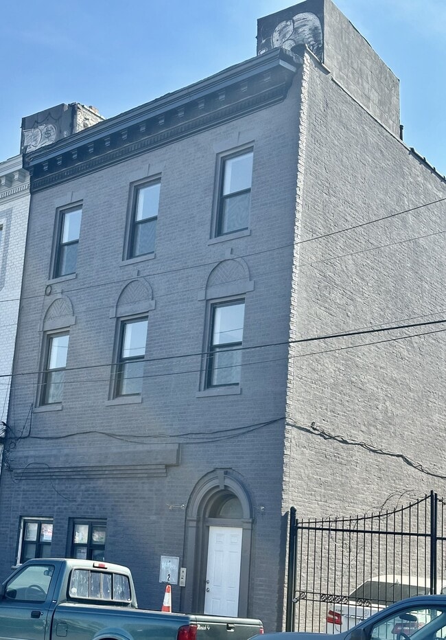
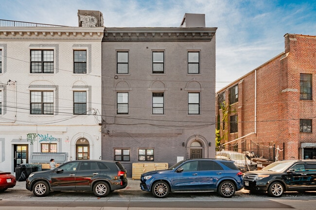
This Property Is For Sale
NEARBY LISTINGS FOR SALE OR LEASE
Property Detail
1860 Flushing Ave
03394-0020
Queens
Triplex
New York
X
20
3604970208F
0.02 AC
2024
Ridgewood
2025
Long Island (New York)
053901
New York-Jersey City-White Plains, NY-NJ
3,237 SF
DEMOGRAPHICS near 1860 Flushing Ave
1 mile
3 mile
5 mile
2024 Total Population
84,747
997,518
3,198,505
2029 Population
78,834
939,772
2,998,088
Pop Growth 2024-2029
(6.98%)
(5.79%)
(6.27%)
Average Age
36
37
39
2024 Total Households
30,221
378,271
1,318,305
HH Growth 2024-2029
(7.54%)
(6.12%)
(6.51%)
Median Household Inc
$73,044
$73,421
$82,842
Avg Household Size
2.70
2.50
2.30
2024 Avg HH Vehicles
1.00
1.00
.00
Median Home Value
$810,738
$827,633
$827,527
Median Year Built
1947
1949
1950
Nearby Places
Map Layers
Map Styles
 Street
 Aerial
Transit
 Traffic
 Biking
Places
Listings with unknown addresses are not visible on the map
- Restaurants
- Banks
- Shops
- Fitness
- Groceries
PUBLIC TRANSPORTATION
TRANSIT/SUBWAY
Jefferson Street (L - New York MTA Subway (The Subway))
Drive
Walk
Distance
Jefferson Street (L - New York MTA Subway (The Subway))
2 min
8 min
0.4 mi
DeKalb Avenue (L Line) (L - New York MTA Subway (The Subway))
Drive
Walk
Distance
DeKalb Avenue (L Line) (L - New York MTA Subway (The Subway))
2 min
14 min
0.7 mi
Morgan Avenue (L - New York MTA Subway (The Subway))
Drive
Walk
Distance
Morgan Avenue (L - New York MTA Subway (The Subway))
3 min
18 min
0.9 mi
Seneca Avenue (M - New York MTA Subway (The Subway))
Drive
Walk
Distance
Seneca Avenue (M - New York MTA Subway (The Subway))
3 min
19 min
1.0 mi
COMMUTER RAIL
Woodside Station (Babylon Branch - Long Island Rail Road, Far Rockaway Branch - Long Island Rail Road, Hempstead Branch - Long Island Rail Road, Long Beach Branch - Long Island Rail Road, Montauk Branch - Long Island Rail Road, Port Jefferson Branch - Long Island Rail Road, Port Washington Branch - Long Island Rail Road, Ronkonkoma Branch - Long Island Rail Road)
Drive
Walk
Distance
Woodside Station (Babylon Branch - Long Island Rail Road, Far Rockaway Branch - Long Island Rail Road, Hempstead Branch - Long Island Rail Road, Long Beach Branch - Long Island Rail Road, Montauk Branch - Long Island Rail Road, Port Jefferson Branch - Long Island Rail Road, Port Washington Branch - Long Island Rail Road, Ronkonkoma Branch - Long Island Rail Road)
8 min
3.4 mi
Nostrand Avenue Station (Far Rockaway Branch - Long Island Rail Road, Hempstead Branch - Long Island Rail Road, Long Beach Branch - Long Island Rail Road, West Hempstead Branch - Long Island Rail Road)
Drive
Walk
Distance
Nostrand Avenue Station (Far Rockaway Branch - Long Island Rail Road, Hempstead Branch - Long Island Rail Road, Long Beach Branch - Long Island Rail Road, West Hempstead Branch - Long Island Rail Road)
12 min
3.6 mi
AIRPORT
LaGuardia
Drive
Walk
Distance
LaGuardia
13 min
6.0 mi
John F Kennedy International
Drive
Walk
Distance
John F Kennedy International
20 min
11.2 mi
Newark Liberty International
Drive
Walk
Distance
Newark Liberty International
31 min
16.8 mi
Freight Ports
NY - Red Hook Container Terminal
Drive
Walk
Distance
NY - Red Hook Container Terminal
14 min
6.5 mi
Nearby Properties
Address
Land Use
TOTAL SIZE
Lot Size
Zoning
Address
Land Use
TOTAL SIZE
Lot Size
Zoning
2,812,739 SF
2.10 AC
C5-3
Address
Land Use
TOTAL SIZE
Lot Size
Zoning
7,058,736 SF
147.61 AC
M3-1
Address
Land Use
TOTAL SIZE
Lot Size
Zoning
1,065,915 SF
2.13 AC
M16R10
Address
Land Use
TOTAL SIZE
Lot Size
Zoning
1,502,532 SF
6.35 AC
R7B
Address
Land Use
TOTAL SIZE
Lot Size
Zoning
805,287 SF
1 AC
R10
Address
Land Use
TOTAL SIZE
Lot Size
Zoning
772,163 SF
5.24 AC
C4-5X
Address
Land Use
TOTAL SIZE
Lot Size
Zoning
445,151 SF
C6-4
Address
Land Use
TOTAL SIZE
Lot Size
Zoning
445,151 SF
C6-4
Address
Land Use
TOTAL SIZE
Lot Size
Zoning
1,030,238 SF
2.94 AC
M15R73
Address
Land Use
TOTAL SIZE
Lot Size
Zoning
1,359,110 SF
1.89 AC
C5-3
Address
Land Use
TOTAL SIZE
Lot Size
Zoning
835,231 SF
11.32 AC
R6
Address
Land Use
TOTAL SIZE
Lot Size
Zoning
410,239 SF
0.77 AC
R10
Address
Land Use
TOTAL SIZE
Lot Size
Zoning
751,223 SF
2.57 AC
R6
Address
Land Use
TOTAL SIZE
Lot Size
Zoning
512,755 SF
1.19 AC
R6
Address
Land Use
TOTAL SIZE
Lot Size
Zoning
724,475 SF
1.85 AC
M3-1
Address
Land Use
TOTAL SIZE
Lot Size
Zoning
724,475 SF
1.85 AC
M3-1
Address
Land Use
TOTAL SIZE
Lot Size
Zoning
724,475 SF
1.85 AC
M3-1
Address
Land Use
TOTAL SIZE
Lot Size
Zoning
724,475 SF
1.85 AC
M3-1
Address
Land Use
TOTAL SIZE
Lot Size
Zoning
724,475 SF
1.85 AC
M3-1
Address
Land Use
TOTAL SIZE
Lot Size
Zoning
724,475 SF
1.85 AC
M3-1
Address
Land Use
TOTAL SIZE
Lot Size
Zoning
724,475 SF
1.85 AC
M3-1
Address
Land Use
TOTAL SIZE
Lot Size
Zoning
724,475 SF
1.85 AC
M3-1
Address
Land Use
TOTAL SIZE
Lot Size
Zoning
724,475 SF
1.85 AC
M3-1
Address
Land Use
TOTAL SIZE
Lot Size
Zoning
724,475 SF
1.85 AC
M3-1
Address
Land Use
TOTAL SIZE
Lot Size
Zoning
724,475 SF
1.85 AC
M3-1
Address
Land Use
TOTAL SIZE
Lot Size
Zoning
724,475 SF
1.85 AC
M3-1
Address
Land Use
TOTAL SIZE
Lot Size
Zoning
724,475 SF
1.85 AC
M3-1
Address
Land Use
TOTAL SIZE
Lot Size
Zoning
724,475 SF
1.85 AC
M3-1
Address
Land Use
TOTAL SIZE
Lot Size
Zoning
724,475 SF
1.85 AC
M3-1
Address
Land Use
TOTAL SIZE
Lot Size
Zoning
724,475 SF
1.85 AC
M3-1
The World's #1 Commercial Real Estate Marketplace
Connect with us
© 2026 CoStar Group
The information above has been obtained from sources believed reliable. While we do not doubt its accuracy we have not verified it and make no guarantee, warranty or representation about it. It is your responsibility to independently confirm its accuracy and completeness. Any projections, opinions, assumptions, or estimates used are for example only and do not represent the current or future performance of the property. The value of this transaction to you depends on tax and other factors which should be evaluated by your tax, financial, and legal advisors. You and your advisors should conduct a careful, independent investigation of the property to determine to your satisfaction the suitability of the property for your needs.