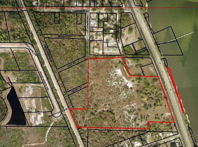
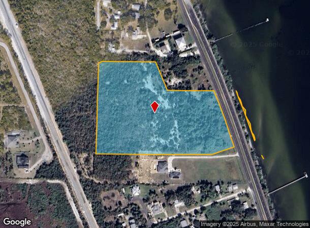
Property Record
1860 S Us Highway 1, Malabar, FL 32950
This Property Is For Sale
NEARBY LISTINGS FOR SALE OR LEASE
Property Detail
1860 S Us Highway 1
Palm Bay-Melbourne-Titusville, FL
PART OF GOVT LOT 1 AS DESC IN ORB 3496 PG 4745 EXC ORB 7185 PG 1297 PAR 4
29-38-06-00-00003.0-0000.00
Brevard
Commercialacreage
Florida
AE
1
12009C0681H
10.53 AC
2024
Brevard County
2025
Orlando
065231
DEMOGRAPHICS near 1860 S Us Highway 1
1 Mile
3 Mile
5 Mile
2024 Total Population
700
14,545
51,227
2029 Population
773
15,973
56,490
Pop Growth 2024-2029
+ 10.43%
+ 9.82%
+ 10.27%
Average Age
47
48
46
2024 Total Households
285
6,220
22,273
HH Growth 2024-2029
+ 10.18%
+ 9.74%
+ 10.13%
Median Household Inc
$58,399
$59,967
$55,575
Avg Household Size
2.50
2.20
2.20
2024 Avg HH Vehicles
2.00
2.00
2.00
Median Home Value
$374,657
$306,086
$253,974
Median Year Built
1986
1982
1985
Nearby Places
Map Layers
Map Styles
 Street
 Aerial
- Restaurants
- Banks
- Shops
- Fitness
- Groceries
PUBLIC TRANSPORTATION
AIRPORT
Melbourne Orlando International
DRIVE
WALK
Distance
Melbourne Orlando International
21 min
10.2 mi
Freight Ports
Port Canaveral
DRIVE
WALK
Distance
Port Canaveral
59 min
46.6 mi
Nearby Properties
Address
Land Use
TOTAL SIZE
Lot Size
Zoning
Address
Land Use
TOTAL SIZE
Lot Size
Zoning
326,454 SF
14.20 AC
RM20
Address
Land Use
TOTAL SIZE
Lot Size
Zoning
2,366 SF
32.43 AC
SR
Address
Land Use
TOTAL SIZE
Lot Size
Zoning
762 SF
49.89 AC
GML
Address
Land Use
TOTAL SIZE
Lot Size
Zoning
161,823 SF
619.70 AC
GML
Address
Land Use
TOTAL SIZE
Lot Size
Zoning
352,735 SF
130.85 AC
Address
Land Use
TOTAL SIZE
Lot Size
Zoning
135,917 SF
2.92 AC
HC
Address
Land Use
TOTAL SIZE
Lot Size
Zoning
35.96 AC
GML
Address
Land Use
TOTAL SIZE
Lot Size
Zoning
222,925 SF
12.75 AC
PUD
Address
Land Use
TOTAL SIZE
Lot Size
Zoning
76,534 SF
4.33 AC
HC
Address
Land Use
TOTAL SIZE
Lot Size
Zoning
109,650 SF
10.32 AC
CG
Address
Land Use
TOTAL SIZE
Lot Size
Zoning
6.48 AC
GML
Address
Land Use
TOTAL SIZE
Lot Size
Zoning
97,728 SF
12.77 AC
IU
Address
Land Use
TOTAL SIZE
Lot Size
Zoning
5.83 AC
GML
Address
Land Use
TOTAL SIZE
Lot Size
Zoning
78,357 SF
8.47 AC
BU1
Address
Land Use
TOTAL SIZE
Lot Size
Zoning
31.07 AC
GML
Address
Land Use
TOTAL SIZE
Lot Size
Zoning
80,425 SF
12.78 AC
HC
Address
Land Use
TOTAL SIZE
Lot Size
Zoning
1,535 SF
3.85 AC
GML
Address
Land Use
TOTAL SIZE
Lot Size
Zoning
4.23 AC
GML
Address
Land Use
TOTAL SIZE
Lot Size
Zoning
12.84 AC
GML
Address
Land Use
TOTAL SIZE
Lot Size
Zoning
14.28 AC
SR
Address
Land Use
TOTAL SIZE
Lot Size
Zoning
27,837 SF
8.24 AC
IN(L)
Address
Land Use
TOTAL SIZE
Lot Size
Zoning
40,192 SF
6.92 AC
HC
Address
Land Use
TOTAL SIZE
Lot Size
Zoning
4.02 AC
GML
Address
Land Use
TOTAL SIZE
Lot Size
Zoning
60,602 SF
5 AC
OI
Address
Land Use
TOTAL SIZE
Lot Size
Zoning
8.15 AC
SR
Address
Land Use
TOTAL SIZE
Lot Size
Zoning
8,853 SF
15.94 AC
CP
Address
Land Use
TOTAL SIZE
Lot Size
Zoning
2.24 AC
GML
Address
Land Use
TOTAL SIZE
Lot Size
Zoning
12.49 AC
HC
Address
Land Use
TOTAL SIZE
Lot Size
Zoning
1.92 AC
GML
Address
Land Use
TOTAL SIZE
Lot Size
Zoning
9.07 AC
GML
The World's #1 Commercial Real Estate Marketplace
Connect with us
© 2026 CoStar Group
The information above has been obtained from sources believed reliable. While we do not doubt its accuracy we have not verified it and make no guarantee, warranty or representation about it. It is your responsibility to independently confirm its accuracy and completeness. Any projections, opinions, assumptions, or estimates used are for example only and do not represent the current or future performance of the property. The value of this transaction to you depends on tax and other factors which should be evaluated by your tax, financial, and legal advisors. You and your advisors should conduct a careful, independent investigation of the property to determine to your satisfaction the suitability of the property for your needs.