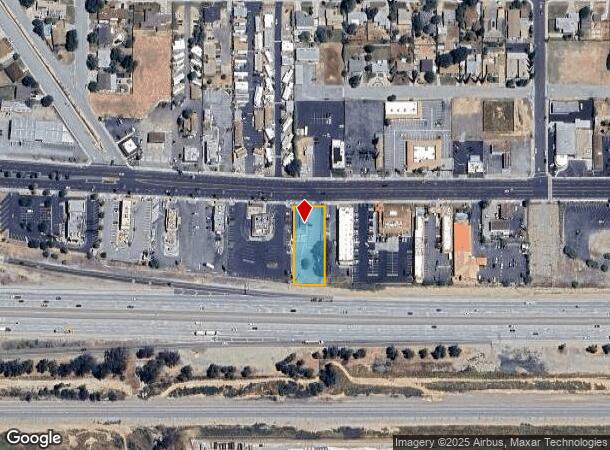
Property Record
1860 W Ramsey St, Banning, CA 92220
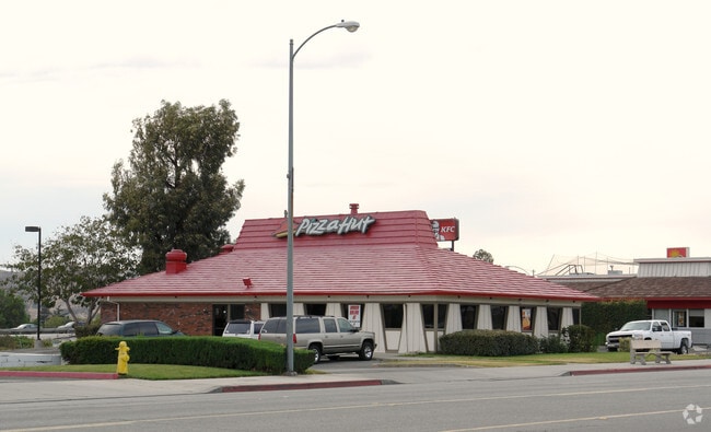
This Property Is For Sale
NEARBY LISTINGS FOR SALE OR LEASE
Property Detail
1860 W Ramsey St
538-210-029
.58 ACRES M/L IN POR PAR 3 PM 011/072 PM 73-4
Restaurantbuilding
Riverside
X
California
06065C0817G
3
2024
0.58 AC
2025
Beaumont/Hemet
044101
Inland Empire (California)
2,736 SF
Riverside-San Bernardino-Ontario, CA
DEMOGRAPHICS near 1860 W Ramsey St
1 Mile
3 Mile
5 Mile
2024 Total Population
8,646
31,397
70,140
2029 Population
9,175
33,108
74,181
Pop Growth 2024-2029
+ 6.12%
+ 5.45%
+ 5.76%
Average Age
37
43
41
2024 Total Households
2,851
11,330
23,961
HH Growth 2024-2029
+ 5.79%
+ 5.12%
+ 5.41%
Median Household Inc
$52,414
$51,530
$66,416
Avg Household Size
3.00
2.60
2.80
2024 Avg HH Vehicles
2.00
2.00
2.00
Median Home Value
$254,207
$298,952
$357,786
Median Year Built
1970
1982
1990
Nearby Places
- Restaurants
- Banks
- Shops
- Fitness
- Groceries
PUBLIC TRANSPORTATION
AIRPORT
Palm Springs International
DRIVE
WALK
Distance
Palm Springs International
33 min
27.4 mi
Freight Ports
Port of Long Beach
DRIVE
WALK
Distance
Port of Long Beach
108 min
85.0 mi
Nearby Properties
Address
Land Use
TOTAL SIZE
Lot Size
Zoning
Address
Land Use
TOTAL SIZE
Lot Size
Zoning
1,000,000 SF
63.69 AC
Address
Land Use
TOTAL SIZE
Lot Size
Zoning
146,056 SF
15.95 AC
Address
Land Use
TOTAL SIZE
Lot Size
Zoning
95,590 SF
7.48 AC
Address
Land Use
TOTAL SIZE
Lot Size
Zoning
116,175 SF
4.86 AC
RA
Address
Land Use
TOTAL SIZE
Lot Size
Zoning
83,989 SF
39.10 AC
M1
Address
Land Use
TOTAL SIZE
Lot Size
Zoning
44,506 SF
2.84 AC
Address
Land Use
TOTAL SIZE
Lot Size
Zoning
54,131 SF
3.23 AC
M1
Address
Land Use
TOTAL SIZE
Lot Size
Zoning
27,359 SF
1.97 AC
C2
Address
Land Use
TOTAL SIZE
Lot Size
Zoning
42,602 SF
3.91 AC
RA
Address
Land Use
TOTAL SIZE
Lot Size
Zoning
59,641 SF
2.02 AC
CPS
Address
Land Use
TOTAL SIZE
Lot Size
Zoning
82,587 SF
6.78 AC
Address
Land Use
TOTAL SIZE
Lot Size
Zoning
39,250 SF
1.38 AC
C2
Address
Land Use
TOTAL SIZE
Lot Size
Zoning
62,796 SF
1.48 AC
Address
Land Use
TOTAL SIZE
Lot Size
Zoning
909 SF
8.17 AC
RA
Address
Land Use
TOTAL SIZE
Lot Size
Zoning
20,800 SF
1.10 AC
C2
Address
Land Use
TOTAL SIZE
Lot Size
Zoning
54,455 SF
5.53 AC
R3
Address
Land Use
TOTAL SIZE
Lot Size
Zoning
44,335 SF
4 AC
Address
Land Use
TOTAL SIZE
Lot Size
Zoning
17,272 SF
1.99 AC
Address
Land Use
TOTAL SIZE
Lot Size
Zoning
119,662 SF
6.65 AC
Address
Land Use
TOTAL SIZE
Lot Size
Zoning
119,400 SF
8.21 AC
M
Address
Land Use
TOTAL SIZE
Lot Size
Zoning
50,000 SF
7.13 AC
CM
Address
Land Use
TOTAL SIZE
Lot Size
Zoning
7,964 SF
1 AC
C1
Address
Land Use
TOTAL SIZE
Lot Size
Zoning
27,660 SF
1.13 AC
R3
Address
Land Use
TOTAL SIZE
Lot Size
Zoning
19,737 SF
1.52 AC
C2
Address
Land Use
TOTAL SIZE
Lot Size
Zoning
26,916 SF
1.23 AC
R3
Address
Land Use
TOTAL SIZE
Lot Size
Zoning
57,253 SF
5.68 AC
Address
Land Use
TOTAL SIZE
Lot Size
Zoning
4,822 SF
0.67 AC
Address
Land Use
TOTAL SIZE
Lot Size
Zoning
14,608 SF
1.40 AC
The World's #1 Commercial Real Estate Marketplace
Connect with us
© 2025 CoStar Group
The information above has been obtained from sources believed reliable. While we do not doubt its accuracy we have not verified it and make no guarantee, warranty or representation about it. It is your responsibility to independently confirm its accuracy and completeness. Any projections, opinions, assumptions, or estimates used are for example only and do not represent the current or future performance of the property. The value of this transaction to you depends on tax and other factors which should be evaluated by your tax, financial, and legal advisors. You and your advisors should conduct a careful, independent investigation of the property to determine to your satisfaction the suitability of the property for your needs.