Property Record
18601 Mack Ave, Grosse Pointe, MI 48236
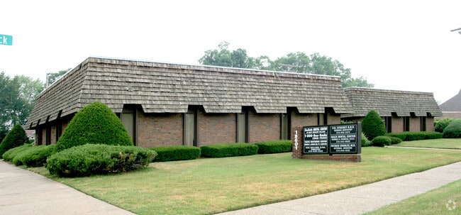

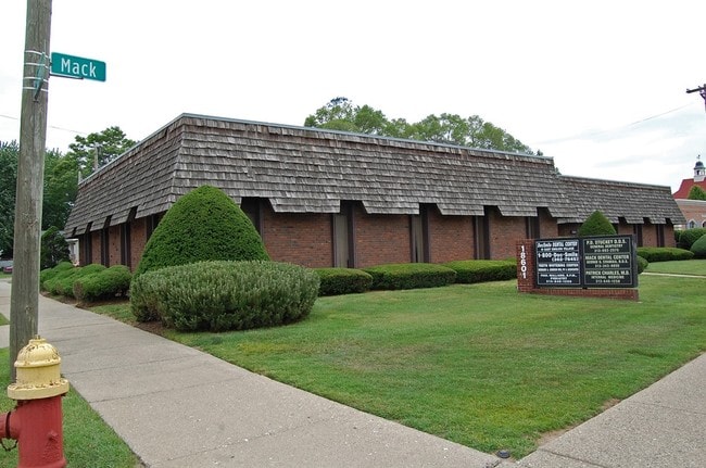
This Property Is For Sale
Property Detail
18601 Mack Ave
21-078576-001
E LA FONTAINE BLDG 1 UNIT 3WAYNE COUNTY CONDOMINIUM SUB PLANNO 219 L23289 P447-84 DEEDS, WCR (LA FONTAINE PROFESSIONAL
Dentalbldg
Wayne
R1
Michigan
B and X Area of moderate flood hazard, usually the area between the limits of the 100-year and 500-year floods.
0.06 AC
2025
Detroit E of Woodward
2025
Detroit
501600
Detroit-Warren-Dearborn, MI
754 SF
NEARBY LISTINGS FOR SALE OR LEASE
DEMOGRAPHICS near 18601 Mack Ave
1 mile
3 mile
5 mile
2025 Total Population
14,969
118,287
247,365
2030 Population
14,763
118,449
251,100
Pop Growth 2025-2030
(1.38%)
+ 0.14%
+ 1.51%
Average Age
40
39
39
2025 Total Households
5,717
44,694
95,300
HH Growth 2025-2030
(1.42%)
(0.03%)
+ 1.37%
Median Household Inc
$81,600
$67,000
$56,788
Avg Household Size
2.60
2.60
2.50
2025 Avg HH Vehicles
2.00
2.00
1.00
Median Home Value
$318,499
$227,831
$159,723
Median Year Built
1949
1950
1952
Nearby Places
Map Layers
Map Styles
 Street
 Aerial
Layers
 Traffic
 Biking
Places
Listings with unknown addresses are not visible on the map
- Restaurants
- Banks
- Shops
- Fitness
- Groceries
PUBLIC TRANSPORTATION
COMMUTER RAIL
Drive
Walk
Distance
18 min
9.8 mi
AIRPORT
Windsor International
Drive
Walk
Distance
Windsor International
43 min
21.2 mi
Detroit Metro Wayne County
Drive
Walk
Distance
Detroit Metro Wayne County
47 min
30.7 mi
Nearby Properties
Address
Land Use
TOTAL SIZE
Lot Size
Zoning
Address
Land Use
TOTAL SIZE
Lot Size
Zoning
1,034,990 SF
28.60 AC
Address
Land Use
TOTAL SIZE
Lot Size
Zoning
211,065 SF
8.84 AC
C.F
Address
Land Use
TOTAL SIZE
Lot Size
Zoning
575,081 SF
8.53 AC
R6
Address
Land Use
TOTAL SIZE
Lot Size
Zoning
101,733 SF
1.10 AC
C-2
Address
Land Use
TOTAL SIZE
Lot Size
Zoning
49,437 SF
0.47 AC
Address
Land Use
TOTAL SIZE
Lot Size
Zoning
93,296 SF
1.05 AC
C-2
Address
Land Use
TOTAL SIZE
Lot Size
Zoning
62,195 SF
1.50 AC
Address
Land Use
TOTAL SIZE
Lot Size
Zoning
75,284 SF
0.87 AC
C
Address
Land Use
TOTAL SIZE
Lot Size
Zoning
17,558 SF
3.15 AC
Address
Land Use
TOTAL SIZE
Lot Size
Zoning
41,000 SF
C-1
Address
Land Use
TOTAL SIZE
Lot Size
Zoning
41,235 SF
8.81 AC
Address
Land Use
TOTAL SIZE
Lot Size
Zoning
30,919 SF
0.86 AC
C
Address
Land Use
TOTAL SIZE
Lot Size
Zoning
28,055 SF
0.44 AC
Address
Land Use
TOTAL SIZE
Lot Size
Zoning
80,320 SF
4.73 AC
RM-1
Address
Land Use
TOTAL SIZE
Lot Size
Zoning
42,113 SF
0.54 AC
Address
Land Use
TOTAL SIZE
Lot Size
Zoning
102,205 SF
214.30 AC
Address
Land Use
TOTAL SIZE
Lot Size
Zoning
20,625 SF
0.48 AC
C-2
Address
Land Use
TOTAL SIZE
Lot Size
Zoning
36,191 SF
3.87 AC
B-2
Address
Land Use
TOTAL SIZE
Lot Size
Zoning
3,312 SF
8.81 AC
R-1A
Address
Land Use
TOTAL SIZE
Lot Size
Zoning
10,704 SF
1.84 AC
Address
Land Use
TOTAL SIZE
Lot Size
Zoning
25,500 SF
0.23 AC
Address
Land Use
TOTAL SIZE
Lot Size
Zoning
101,814 SF
3.74 AC
R-2
Address
Land Use
TOTAL SIZE
Lot Size
Zoning
60,484 SF
4.85 AC
PD
Address
Land Use
TOTAL SIZE
Lot Size
Zoning
38,577 SF
1.91 AC
C
Address
Land Use
TOTAL SIZE
Lot Size
Zoning
43,967 SF
2.80 AC
O-1
Address
Land Use
TOTAL SIZE
Lot Size
Zoning
137,284 SF
13.55 AC
RS-1
Address
Land Use
TOTAL SIZE
Lot Size
Zoning
33,646 SF
1.83 AC
B-1
Address
Land Use
TOTAL SIZE
Lot Size
Zoning
37.36 AC
RS-1
Address
Land Use
TOTAL SIZE
Lot Size
Zoning
14,820 SF
0.41 AC
C-1
Address
Land Use
TOTAL SIZE
Lot Size
Zoning
124,770 SF
10.99 AC
RS-1
The World's #1 Commercial Real Estate Marketplace
Connect with us
© 2026 CoStar Group
The information above has been obtained from sources believed reliable. While we do not doubt its accuracy we have not verified it and make no guarantee, warranty or representation about it. It is your responsibility to independently confirm its accuracy and completeness. Any projections, opinions, assumptions, or estimates used are for example only and do not represent the current or future performance of the property. The value of this transaction to you depends on tax and other factors which should be evaluated by your tax, financial, and legal advisors. You and your advisors should conduct a careful, independent investigation of the property to determine to your satisfaction the suitability of the property for your needs.