Property Record
1861 View St, Myrtle Point, OR 97458
NEARBY LISTINGS FOR SALE OR LEASE
-
-
View all Myrtle Point listings for sale on LoopNet.com
Property Detail
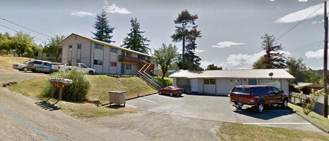
1861 View St
1007356600
Parry Addition
Quadruplex
Coos
X
Oregon
41011C0742F
2400
2025
0.16 AC
2025
Other Market Areas
001102
Coos Bay-North Bend, OR
3,900 SF
DEMOGRAPHICS near 1861 View St
1 Mile
3 Mile
5 Mile
2024 Total Population
2,485
3,174
3,843
2029 Population
2,506
3,197
3,866
Pop Growth 2024-2029
+ 0.85%
+ 0.72%
+ 0.60%
Average Age
44
45
45
2024 Total Households
1,043
1,323
1,596
HH Growth 2024-2029
+ 0.86%
+ 0.83%
+ 0.63%
Median Household Inc
$45,213
$46,228
$46,875
Avg Household Size
2.30
2.30
2.30
2024 Avg HH Vehicles
2.00
2.00
2.00
Median Home Value
$229,444
$236,890
$243,535
Median Year Built
1967
1968
1969
Nearby Places
Map Layers
Map Styles
 Street
 Aerial
- Restaurants
- Banks
- Shops
- Fitness
- Groceries
SALE & LEASE HISTORY
LISTING DATE
SALE/LEASE

Oct 24, 2018
For Sale
Nearby Properties
Address
Land Use
TOTAL SIZE
Lot Size
Zoning
Address
Land Use
TOTAL SIZE
Lot Size
Zoning
7.35 AC
OS/PF
Address
Land Use
TOTAL SIZE
Lot Size
Zoning
15,000 SF
6.10 AC
R
Address
Land Use
TOTAL SIZE
Lot Size
Zoning
9.96 AC
R-1
Address
Land Use
TOTAL SIZE
Lot Size
Zoning
13,400 SF
0.92 AC
CR
Address
Land Use
TOTAL SIZE
Lot Size
Zoning
3,082 SF
0.34 AC
CR
Address
Land Use
TOTAL SIZE
Lot Size
Zoning
13.70 AC
R-1
Address
Land Use
TOTAL SIZE
Lot Size
Zoning
900 SF
85.09 AC
F
Address
Land Use
TOTAL SIZE
Lot Size
Zoning
17,335 SF
0.33 AC
R
Address
Land Use
TOTAL SIZE
Lot Size
Zoning
18,100 SF
0.80 AC
CR
Address
Land Use
TOTAL SIZE
Lot Size
Zoning
0.42 AC
CR
Address
Land Use
TOTAL SIZE
Lot Size
Zoning
840 SF
10.91 AC
Address
Land Use
TOTAL SIZE
Lot Size
Zoning
3,851 SF
160 AC
F/EFU
Address
Land Use
TOTAL SIZE
Lot Size
Zoning
13,516 SF
0.91 AC
R-1
Address
Land Use
TOTAL SIZE
Lot Size
Zoning
9,300 SF
0.44 AC
CR
Address
Land Use
TOTAL SIZE
Lot Size
Zoning
6,779 SF
0.21 AC
CR
Address
Land Use
TOTAL SIZE
Lot Size
Zoning
10,447 SF
2.44 AC
CR
Address
Land Use
TOTAL SIZE
Lot Size
Zoning
3,786 SF
0.44 AC
CR
Address
Land Use
TOTAL SIZE
Lot Size
Zoning
10,248 SF
0.97 AC
CR
Address
Land Use
TOTAL SIZE
Lot Size
Zoning
672 SF
4.38 AC
Address
Land Use
TOTAL SIZE
Lot Size
Zoning
3,712 SF
0.44 AC
CR
Address
Land Use
TOTAL SIZE
Lot Size
Zoning
4,150 SF
30.07 AC
EFU
Address
Land Use
TOTAL SIZE
Lot Size
Zoning
Address
Land Use
TOTAL SIZE
Lot Size
Zoning
2,714 SF
58.55 AC
F, EFU
Address
Land Use
TOTAL SIZE
Lot Size
Zoning
Address
Land Use
TOTAL SIZE
Lot Size
Zoning
8.05 AC
IND
Address
Land Use
TOTAL SIZE
Lot Size
Zoning
3,936 SF
1.31 AC
IND
Address
Land Use
TOTAL SIZE
Lot Size
Zoning
2,348 SF
37.70 AC
EFU
Address
Land Use
TOTAL SIZE
Lot Size
Zoning
3,848 SF
20.50 AC
F
Address
Land Use
TOTAL SIZE
Lot Size
Zoning
2,298 SF
0.33 AC
CR
Address
Land Use
TOTAL SIZE
Lot Size
Zoning
3,380 SF
94.18 AC
EFU/F
The World's #1 Commercial Real Estate Marketplace
Connect with us
© 2026 CoStar Group
The information above has been obtained from sources believed reliable. While we do not doubt its accuracy we have not verified it and make no guarantee, warranty or representation about it. It is your responsibility to independently confirm its accuracy and completeness. Any projections, opinions, assumptions, or estimates used are for example only and do not represent the current or future performance of the property. The value of this transaction to you depends on tax and other factors which should be evaluated by your tax, financial, and legal advisors. You and your advisors should conduct a careful, independent investigation of the property to determine to your satisfaction the suitability of the property for your needs.