Property Record
1863 W Main St, Riverhead, NY 11901
NEARBY LISTINGS FOR SALE OR LEASE
Property Detail
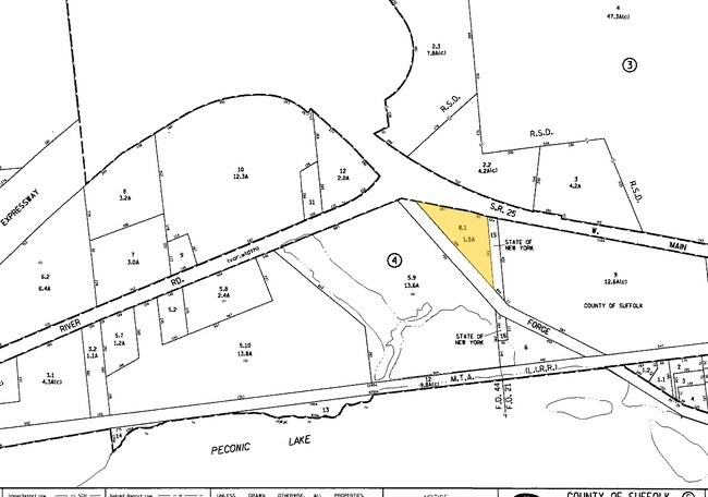
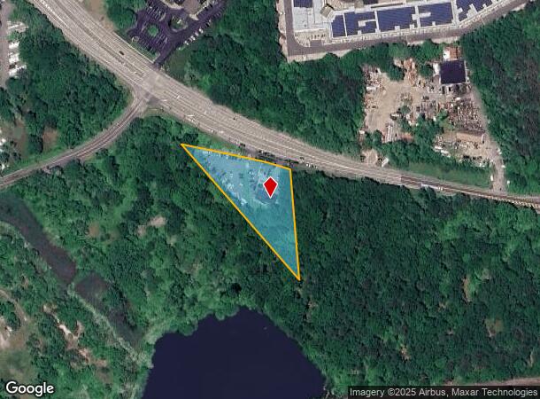
1863 W Main St
0600-118-00-04-00-008-001
N X W MAIN E X NY STATE W X FORGE RD
Autorepair
Suffolk
X
New York
36103C0461H
8
2024
1.50 AC
2024
Eastern Suffolk
169706
Long Island (New York)
1,364 SF
Nassau County-Suffolk County, NY
DEMOGRAPHICS near 1863 W Main St
1 Mile
3 Mile
5 Mile
2024 Total Population
1,882
13,618
33,332
2029 Population
1,842
13,497
33,322
Pop Growth 2024-2029
(2.13%)
(0.89%)
(0.03%)
Average Age
52
44
43
2024 Total Households
987
5,239
12,345
HH Growth 2024-2029
(2.53%)
(1.09%)
(0.10%)
Median Household Inc
$48,964
$62,480
$69,289
Avg Household Size
1.90
2.50
2.60
2024 Avg HH Vehicles
1.00
2.00
2.00
Median Home Value
$135,000
$383,738
$414,768
Median Year Built
1983
1984
1984
Nearby Places
- Restaurants
- Banks
- Shops
- Fitness
- Groceries
PUBLIC TRANSPORTATION
COMMUTER RAIL
Riverhead Station (Greenport Branch - Long Island Rail Road)
DRIVE
WALK
Distance
Riverhead Station (Greenport Branch - Long Island Rail Road)
6 min
3.1 mi
AIRPORT
Long Island MacArthur
DRIVE
WALK
Distance
Long Island MacArthur
40 min
25.9 mi
Freight Ports
Port of New Haven
DRIVE
WALK
Distance
Port of New Haven
142 min
57.2 mi
Nearby Properties
Address
Land Use
TOTAL SIZE
Lot Size
Zoning
Address
Land Use
TOTAL SIZE
Lot Size
Zoning
233,668 SF
82.70 AC
CR200
Address
Land Use
TOTAL SIZE
Lot Size
Zoning
450,000 SF
8.50 AC
3
Address
Land Use
TOTAL SIZE
Lot Size
Zoning
252,053 SF
31.60 AC
3
Address
Land Use
TOTAL SIZE
Lot Size
Zoning
42.70 AC
9
Address
Land Use
TOTAL SIZE
Lot Size
Zoning
49,680 SF
1.30 AC
8
Address
Land Use
TOTAL SIZE
Lot Size
Zoning
176,704 SF
34.70 AC
3
Address
Land Use
TOTAL SIZE
Lot Size
Zoning
47.30 AC
9
Address
Land Use
TOTAL SIZE
Lot Size
Zoning
127,334 SF
49.72 AC
04
Address
Land Use
TOTAL SIZE
Lot Size
Zoning
109.90 AC
Address
Land Use
TOTAL SIZE
Lot Size
Zoning
17 AC
CR200
Address
Land Use
TOTAL SIZE
Lot Size
Zoning
2,010 SF
115.10 AC
09
Address
Land Use
TOTAL SIZE
Lot Size
Zoning
23,743 SF
5.80 AC
MTL
Address
Land Use
TOTAL SIZE
Lot Size
Zoning
25,620 SF
7.03 AC
9
Address
Land Use
TOTAL SIZE
Lot Size
Zoning
9,715 SF
82.50 AC
9
Address
Land Use
TOTAL SIZE
Lot Size
Zoning
13.92 AC
04
Address
Land Use
TOTAL SIZE
Lot Size
Zoning
16,699 SF
24.81 AC
03
Address
Land Use
TOTAL SIZE
Lot Size
Zoning
20.72 AC
09
Address
Land Use
TOTAL SIZE
Lot Size
Zoning
68.90 AC
H2O
Address
Land Use
TOTAL SIZE
Lot Size
Zoning
26.39 AC
04
Address
Land Use
TOTAL SIZE
Lot Size
Zoning
92.73 AC
Address
Land Use
TOTAL SIZE
Lot Size
Zoning
108,572 SF
17.30 AC
04
Address
Land Use
TOTAL SIZE
Lot Size
Zoning
13,773 SF
11.65 AC
03
Address
Land Use
TOTAL SIZE
Lot Size
Zoning
36.60 AC
RC
Address
Land Use
TOTAL SIZE
Lot Size
Zoning
1,435 SF
13.20 AC
Address
Land Use
TOTAL SIZE
Lot Size
Zoning
4,410 SF
1 AC
OD
Address
Land Use
TOTAL SIZE
Lot Size
Zoning
15,819 SF
1.08 AC
HB
Address
Land Use
TOTAL SIZE
Lot Size
Zoning
292.40 AC
CR200
Address
Land Use
TOTAL SIZE
Lot Size
Zoning
2,860 SF
9.38 AC
3
Address
Land Use
TOTAL SIZE
Lot Size
Zoning
15.40 AC
RA40
Address
Land Use
TOTAL SIZE
Lot Size
Zoning
12,570 SF
1.63 AC
8
The World's #1 Commercial Real Estate Marketplace
Connect with us
© 2025 CoStar Group
The information above has been obtained from sources believed reliable. While we do not doubt its accuracy we have not verified it and make no guarantee, warranty or representation about it. It is your responsibility to independently confirm its accuracy and completeness. Any projections, opinions, assumptions, or estimates used are for example only and do not represent the current or future performance of the property. The value of this transaction to you depends on tax and other factors which should be evaluated by your tax, financial, and legal advisors. You and your advisors should conduct a careful, independent investigation of the property to determine to your satisfaction the suitability of the property for your needs.