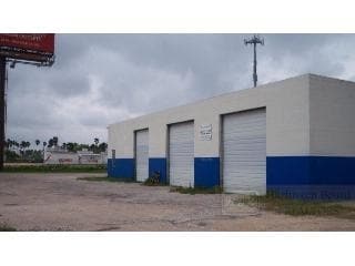
Property Record
18635 Off Primera Rd, Primera, TX 78550

NEARBY LISTINGS FOR SALE OR LEASE
Property Detail
18635 Off Primera Rd
Brownsville-Harlingen, TX
Cunningham Subdivision
490150-0010-020000
PRIMERA - CUNNINGHAM BLK 1, 3.7980 ACRES
Commercialnec
Cameron
X
Texas
48061C0255F
200
2024
3.80 AC
2025
Outlying Cameron County
010700
Brownsville/Harlingen
11,496 SF
DEMOGRAPHICS near 18635 Off Primera Rd
1 Mile
3 Mile
5 Mile
2024 Total Population
4,586
37,815
83,055
2029 Population
4,585
38,463
84,933
Pop Growth 2024-2029
(0.02%)
+ 1.71%
+ 2.26%
Average Age
38
37
37
2024 Total Households
1,461
12,680
28,319
HH Growth 2024-2029
(0.27%)
+ 1.66%
+ 2.26%
Median Household Inc
$50,615
$52,181
$50,414
Avg Household Size
3.00
2.90
2.80
2024 Avg HH Vehicles
2.00
2.00
2.00
Median Home Value
$74,363
$105,175
$102,805
Median Year Built
1990
1987
1986
Nearby Places
Map Layers
Map Styles
 Street
 Aerial
- Restaurants
- Banks
- Shops
- Fitness
- Groceries
PUBLIC TRANSPORTATION
AIRPORT
Valley International
DRIVE
WALK
Distance
Valley International
8 min
4.2 mi
Brownsville/South Padre Island International
DRIVE
WALK
Distance
Brownsville/South Padre Island International
40 min
31.0 mi
Freight Ports
Port of Brownsville
DRIVE
WALK
Distance
Port of Brownsville
32 min
28.6 mi
Nearby Properties
Address
Land Use
TOTAL SIZE
Lot Size
Zoning
Address
Land Use
TOTAL SIZE
Lot Size
Zoning
43,540 SF
26.19 AC
C
Address
Land Use
TOTAL SIZE
Lot Size
Zoning
293,886 SF
23.57 AC
Address
Land Use
TOTAL SIZE
Lot Size
Zoning
74,848 SF
2.30 AC
Address
Land Use
TOTAL SIZE
Lot Size
Zoning
72,063 SF
2.29 AC
Address
Land Use
TOTAL SIZE
Lot Size
Zoning
152,724 SF
17.78 AC
Address
Land Use
TOTAL SIZE
Lot Size
Zoning
63,450 SF
2.88 AC
Address
Land Use
TOTAL SIZE
Lot Size
Zoning
13,924 SF
31.33 AC
C
Address
Land Use
TOTAL SIZE
Lot Size
Zoning
15,085 SF
51.10 AC
C
Address
Land Use
TOTAL SIZE
Lot Size
Zoning
76,756 SF
15.35 AC
Address
Land Use
TOTAL SIZE
Lot Size
Zoning
63,381 SF
3.15 AC
Address
Land Use
TOTAL SIZE
Lot Size
Zoning
81,569 SF
36.61 AC
Address
Land Use
TOTAL SIZE
Lot Size
Zoning
134,367 SF
14.42 AC
Address
Land Use
TOTAL SIZE
Lot Size
Zoning
20.64 AC
C
Address
Land Use
TOTAL SIZE
Lot Size
Zoning
47,388 SF
11.64 AC
Address
Land Use
TOTAL SIZE
Lot Size
Zoning
73,669 SF
9.47 AC
C
Address
Land Use
TOTAL SIZE
Lot Size
Zoning
147,186 SF
10 AC
Address
Land Use
TOTAL SIZE
Lot Size
Zoning
144,000 SF
7.05 AC
Address
Land Use
TOTAL SIZE
Lot Size
Zoning
43,715 SF
8 AC
Address
Land Use
TOTAL SIZE
Lot Size
Zoning
82,320 SF
5.79 AC
Address
Land Use
TOTAL SIZE
Lot Size
Zoning
194,090 SF
13.17 AC
C
Address
Land Use
TOTAL SIZE
Lot Size
Zoning
1,216 SF
39.91 AC
A-R
Address
Land Use
TOTAL SIZE
Lot Size
Zoning
141,841 SF
9.99 AC
Address
Land Use
TOTAL SIZE
Lot Size
Zoning
95,867 SF
11.11 AC
C
Address
Land Use
TOTAL SIZE
Lot Size
Zoning
13,496 SF
0.99 AC
Address
Land Use
TOTAL SIZE
Lot Size
Zoning
256,460 SF
19.15 AC
C
Address
Land Use
TOTAL SIZE
Lot Size
Zoning
98,996 SF
3.53 AC
Address
Land Use
TOTAL SIZE
Lot Size
Zoning
56,703 SF
11.40 AC
Address
Land Use
TOTAL SIZE
Lot Size
Zoning
94,044 SF
7.60 AC
Address
Land Use
TOTAL SIZE
Lot Size
Zoning
41,600 SF
10 AC
C
Address
Land Use
TOTAL SIZE
Lot Size
Zoning
52,630 SF
15 AC
The World's #1 Commercial Real Estate Marketplace
Connect with us
© 2026 CoStar Group
The information above has been obtained from sources believed reliable. While we do not doubt its accuracy we have not verified it and make no guarantee, warranty or representation about it. It is your responsibility to independently confirm its accuracy and completeness. Any projections, opinions, assumptions, or estimates used are for example only and do not represent the current or future performance of the property. The value of this transaction to you depends on tax and other factors which should be evaluated by your tax, financial, and legal advisors. You and your advisors should conduct a careful, independent investigation of the property to determine to your satisfaction the suitability of the property for your needs.