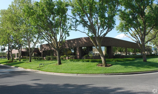
Property Record
18635 Sutter Blvd, Morgan Hill, CA 95037

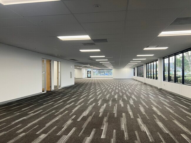

Current Lease Availabilities
Property Detail
18635 Sutter Blvd
Scientificpharmaceuticalmedicalresearchfacility
Santa Clara
M
California
C and X Area of minimal flood hazard, usually depicted on FIRMs as above the 500-year flood level.
1.93 AC
2024
Morgan Hill
2025
South Bay/San Jose
512311
San Jose-Sunnyvale-Santa Clara, CA
25,186 SF
726-33-016
NEARBY LISTINGS FOR SALE OR LEASE
DEMOGRAPHICS near 18635 Sutter Blvd
1 mile
3 mile
5 mile
2025 Total Population
7,442
39,561
53,440
2030 Population
7,695
40,519
54,469
Pop Growth 2025-2030
+ 3.40%
+ 2.42%
+ 1.93%
Average Age
40
40
41
2025 Total Households
2,380
12,731
17,458
HH Growth 2025-2030
+ 3.53%
+ 2.47%
+ 1.95%
Median Household Inc
$169,680
$155,121
$158,876
Avg Household Size
3.10
3.00
3.00
2025 Avg HH Vehicles
2.00
2.00
2.00
Median Home Value
$1,036,996
$1,057,320
$1,068,419
Median Year Built
1996
1990
1985
Nearby Places
Map Layers
Map Styles
 Street
 Aerial
Transit
 Traffic
 Biking
Places
Listings with unknown addresses are not visible on the map
- Restaurants
- Banks
- Shops
- Fitness
- Groceries
Nearby Properties
Address
Land Use
TOTAL SIZE
Lot Size
Zoning
Address
Land Use
TOTAL SIZE
Lot Size
Zoning
23.35 AC
PUD
Address
Land Use
TOTAL SIZE
Lot Size
Zoning
7.53 AC
CT
Address
Land Use
TOTAL SIZE
Lot Size
Zoning
223,897 SF
8.25 AC
A-20A
Address
Land Use
TOTAL SIZE
Lot Size
Zoning
19.50 AC
RAM
Address
Land Use
TOTAL SIZE
Lot Size
Zoning
257,296 SF
14.71 AC
M
Address
Land Use
TOTAL SIZE
Lot Size
Zoning
133,738 SF
5.66 AC
APD
Address
Land Use
TOTAL SIZE
Lot Size
Zoning
9.18 AC
IL
Address
Land Use
TOTAL SIZE
Lot Size
Zoning
128,450 SF
1.65 AC
CC
Address
Land Use
TOTAL SIZE
Lot Size
Zoning
6.84 AC
IL
Address
Land Use
TOTAL SIZE
Lot Size
Zoning
8.65 AC
IL
Address
Land Use
TOTAL SIZE
Lot Size
Zoning
285,877 SF
16.30 AC
MPUD
Address
Land Use
TOTAL SIZE
Lot Size
Zoning
112,738 SF
4.05 AC
R3
Address
Land Use
TOTAL SIZE
Lot Size
Zoning
91,853 SF
5.30 AC
M
Address
Land Use
TOTAL SIZE
Lot Size
Zoning
91,712 SF
4.03 AC
R3
Address
Land Use
TOTAL SIZE
Lot Size
Zoning
79,059 SF
5.87 AC
M1
Address
Land Use
TOTAL SIZE
Lot Size
Zoning
85,456 SF
4.98 AC
M
Address
Land Use
TOTAL SIZE
Lot Size
Zoning
76,845 SF
2.43 AC
A140
Address
Land Use
TOTAL SIZE
Lot Size
Zoning
400 SF
756.21 AC
A(PD)
Address
Land Use
TOTAL SIZE
Lot Size
Zoning
151,242 SF
10.44 AC
ML
Address
Land Use
TOTAL SIZE
Lot Size
Zoning
4.95 AC
M
Address
Land Use
TOTAL SIZE
Lot Size
Zoning
82,446 SF
5.32 AC
M
Address
Land Use
TOTAL SIZE
Lot Size
Zoning
60,890 SF
1.73 AC
R3
Address
Land Use
TOTAL SIZE
Lot Size
Zoning
65,809 SF
2.93 AC
R3
Address
Land Use
TOTAL SIZE
Lot Size
Zoning
4.53 AC
IL
Address
Land Use
TOTAL SIZE
Lot Size
Zoning
73,600 SF
5 AC
M
Address
Land Use
TOTAL SIZE
Lot Size
Zoning
137,553 SF
8.09 AC
R3
Address
Land Use
TOTAL SIZE
Lot Size
Zoning
9.24 AC
PUD
Address
Land Use
TOTAL SIZE
Lot Size
Zoning
4.30 AC
M
Address
Land Use
TOTAL SIZE
Lot Size
Zoning
58,035 SF
2.60 AC
PUDHC
Address
Land Use
TOTAL SIZE
Lot Size
Zoning
2.25 AC
MH
The World's #1 Commercial Real Estate Marketplace
Connect with us
© 2026 CoStar Group
The information above has been obtained from sources believed reliable. While we do not doubt its accuracy we have not verified it and make no guarantee, warranty or representation about it. It is your responsibility to independently confirm its accuracy and completeness. Any projections, opinions, assumptions, or estimates used are for example only and do not represent the current or future performance of the property. The value of this transaction to you depends on tax and other factors which should be evaluated by your tax, financial, and legal advisors. You and your advisors should conduct a careful, independent investigation of the property to determine to your satisfaction the suitability of the property for your needs.