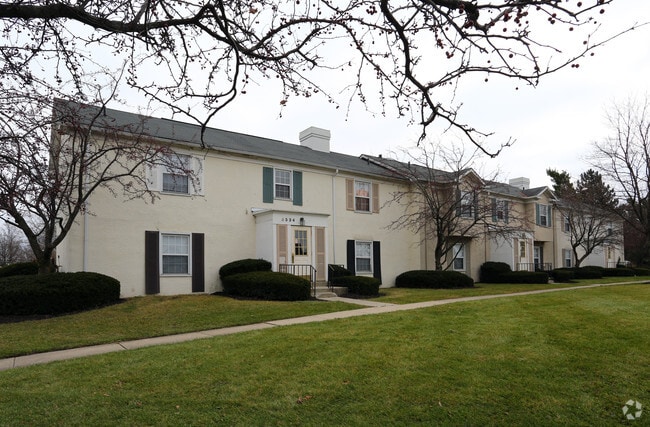
Property Record
1864 N Tamarack Cir N, Columbus, OH 43229


NEARBY LISTINGS FOR SALE OR LEASE
-
-
View all Columbus listings for sale on LoopNet.com
Property Detail
1864 N Tamarack Cir N
010-149680
Forest Park East Sec 7
Apartment
FOREST PK EAST SEC 3 RES-A
X
Franklin
39049C0179K
Ohio
2024
6.06 AC
2024
Forest Park East
006932
Columbus
93,780 SF
Columbus, OH
DEMOGRAPHICS near 1864 N Tamarack Cir N
1 Mile
3 Mile
5 Mile
2024 Total Population
23,537
127,940
317,650
2029 Population
23,337
127,151
318,290
Pop Growth 2024-2029
(0.85%)
(0.62%)
+ 0.20%
Average Age
36
37
38
2024 Total Households
8,398
50,840
130,812
HH Growth 2024-2029
(0.85%)
(0.64%)
+ 0.27%
Median Household Inc
$47,965
$56,183
$65,271
Avg Household Size
2.70
2.40
2.40
2024 Avg HH Vehicles
2.00
2.00
2.00
Median Home Value
$178,696
$194,681
$244,326
Median Year Built
1970
1970
1973
Nearby Places
Map Layers
Map Styles
 Street
 Aerial
- Restaurants
- Banks
- Shops
- Fitness
- Groceries
PUBLIC TRANSPORTATION
AIRPORT
John Glenn Columbus International
DRIVE
WALK
Distance
John Glenn Columbus International
18 min
10.3 mi
Rickenbacker International
DRIVE
WALK
Distance
Rickenbacker International
36 min
24.5 mi
Freight Ports
Port of Toledo
DRIVE
WALK
Distance
Port of Toledo
175 min
141.9 mi
Nearby Properties
Address
Land Use
TOTAL SIZE
Lot Size
Zoning
Address
Land Use
TOTAL SIZE
Lot Size
Zoning
440,828 SF
13.72 AC
Address
Land Use
TOTAL SIZE
Lot Size
Zoning
516,485 SF
50.03 AC
Address
Land Use
TOTAL SIZE
Lot Size
Zoning
697,077 SF
40.91 AC
Address
Land Use
TOTAL SIZE
Lot Size
Zoning
286,169 SF
11.08 AC
Address
Land Use
TOTAL SIZE
Lot Size
Zoning
152,684 SF
20.94 AC
Address
Land Use
TOTAL SIZE
Lot Size
Zoning
201,072 SF
22.28 AC
Address
Land Use
TOTAL SIZE
Lot Size
Zoning
142,998 SF
30.25 AC
Address
Land Use
TOTAL SIZE
Lot Size
Zoning
167,479 SF
36.79 AC
Address
Land Use
TOTAL SIZE
Lot Size
Zoning
170,237 SF
97.38 AC
Address
Land Use
TOTAL SIZE
Lot Size
Zoning
184,756 SF
23.53 AC
Address
Land Use
TOTAL SIZE
Lot Size
Zoning
358,264 SF
10.88 AC
Address
Land Use
TOTAL SIZE
Lot Size
Zoning
172,848 SF
5.34 AC
Address
Land Use
TOTAL SIZE
Lot Size
Zoning
148.89 AC
Address
Land Use
TOTAL SIZE
Lot Size
Zoning
122,920 SF
20.30 AC
Address
Land Use
TOTAL SIZE
Lot Size
Zoning
85,228 SF
45.03 AC
Address
Land Use
TOTAL SIZE
Lot Size
Zoning
30,383 SF
20.72 AC
Address
Land Use
TOTAL SIZE
Lot Size
Zoning
111,168 SF
19.43 AC
Address
Land Use
TOTAL SIZE
Lot Size
Zoning
74,544 SF
10.52 AC
Address
Land Use
TOTAL SIZE
Lot Size
Zoning
65,125 SF
11.98 AC
Address
Land Use
TOTAL SIZE
Lot Size
Zoning
174,736 SF
5.50 AC
Address
Land Use
TOTAL SIZE
Lot Size
Zoning
407,325 SF
27.53 AC
Address
Land Use
TOTAL SIZE
Lot Size
Zoning
169,442 SF
7.76 AC
Address
Land Use
TOTAL SIZE
Lot Size
Zoning
130,059 SF
25.97 AC
Address
Land Use
TOTAL SIZE
Lot Size
Zoning
140,912 SF
36.59 AC
Address
Land Use
TOTAL SIZE
Lot Size
Zoning
161,281 SF
11.81 AC
Address
Land Use
TOTAL SIZE
Lot Size
Zoning
179,824 SF
13.65 AC
Address
Land Use
TOTAL SIZE
Lot Size
Zoning
68,702 SF
4.90 AC
Address
Land Use
TOTAL SIZE
Lot Size
Zoning
209,350 SF
16.44 AC
Address
Land Use
TOTAL SIZE
Lot Size
Zoning
105,720 SF
0.94 AC
Address
Land Use
TOTAL SIZE
Lot Size
Zoning
13,004 SF
16.29 AC
The World's #1 Commercial Real Estate Marketplace
Connect with us
© 2025 CoStar Group
The information above has been obtained from sources believed reliable. While we do not doubt its accuracy we have not verified it and make no guarantee, warranty or representation about it. It is your responsibility to independently confirm its accuracy and completeness. Any projections, opinions, assumptions, or estimates used are for example only and do not represent the current or future performance of the property. The value of this transaction to you depends on tax and other factors which should be evaluated by your tax, financial, and legal advisors. You and your advisors should conduct a careful, independent investigation of the property to determine to your satisfaction the suitability of the property for your needs.