Property Record
18643 Fm Rd 1431, Leander, TX 78645
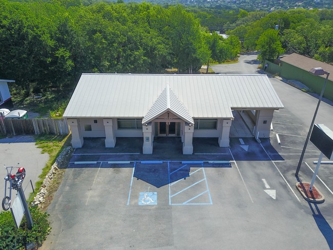

Property Detail
18643 Fm Rd 1431
184387
.3846 AC OF BLK C JONESTOWN
Financialbuilding
TRAVIS
B and X Area of moderate flood hazard, usually the area between the limits of the 100-year and 500-year floods.
Texas
2025
0.39 AC
2025
Far Northwest
037600
Austin
1,380 SF
Austin-Round Rock-San Marcos, TX
NEARBY LISTINGS FOR SALE OR LEASE
DEMOGRAPHICS near 18643 Fm Rd 1431
1 mile
3 mile
5 mile
2025 Total Population
2,044
9,177
53,910
2030 Population
2,183
9,891
58,685
Pop Growth 2025-2030
+ 6.80%
+ 7.78%
+ 8.86%
Average Age
47
44
41
2025 Total Households
875
3,455
19,000
HH Growth 2025-2030
+ 7.43%
+ 8.31%
+ 9.48%
Median Household Inc
$108,290
$131,103
$157,260
Avg Household Size
2.30
2.60
2.80
2025 Avg HH Vehicles
2.00
2.00
2.00
Median Home Value
$644,444
$728,540
$649,225
Median Year Built
1997
2009
2006
Nearby Places
Map Layers
Map Styles
 Street
 Aerial
Layers
 Traffic
 Biking
Places
Listings with unknown addresses are not visible on the map
- Restaurants
- Banks
- Shops
- Fitness
- Groceries
PUBLIC TRANSPORTATION
AIRPORT
Austin-Bergstrom International
Drive
Walk
Distance
Austin-Bergstrom International
46 min
39.9 mi
Freight Ports
Calhoun Port
Drive
Walk
Distance
Calhoun Port
1 min
150.3 mi
SALE & LEASE HISTORY
LISTING DATE
SALE/LEASE

May 22, 2017
For Sale
Mar 13, 2019
For Lease
Jun 22, 2018
For Lease
Jun 22, 2018
For Sale
Jun 02, 2017
For Sale
Jul 25, 2018
For Sale
Nearby Properties
Address
Land Use
TOTAL SIZE
Lot Size
Zoning
Address
Land Use
TOTAL SIZE
Lot Size
Zoning
2,327 SF
810.41 AC
Address
Land Use
TOTAL SIZE
Lot Size
Zoning
670.57 AC
Address
Land Use
TOTAL SIZE
Lot Size
Zoning
2,366 SF
6.68 AC
Address
Land Use
TOTAL SIZE
Lot Size
Zoning
92,252 SF
10.12 AC
Address
Land Use
TOTAL SIZE
Lot Size
Zoning
2,744 SF
299.90 AC
Address
Land Use
TOTAL SIZE
Lot Size
Zoning
560 SF
38.01 AC
Address
Land Use
TOTAL SIZE
Lot Size
Zoning
13,714 SF
30.56 AC
Address
Land Use
TOTAL SIZE
Lot Size
Zoning
584.77 AC
Address
Land Use
TOTAL SIZE
Lot Size
Zoning
46,955 SF
3.09 AC
Address
Land Use
TOTAL SIZE
Lot Size
Zoning
42,843 SF
3.74 AC
Address
Land Use
TOTAL SIZE
Lot Size
Zoning
107.45 AC
Address
Land Use
TOTAL SIZE
Lot Size
Zoning
26.88 AC
Address
Land Use
TOTAL SIZE
Lot Size
Zoning
99.58 AC
Address
Land Use
TOTAL SIZE
Lot Size
Zoning
5.48 AC
Address
Land Use
TOTAL SIZE
Lot Size
Zoning
28,000 SF
10.30 AC
Address
Land Use
TOTAL SIZE
Lot Size
Zoning
138.92 AC
Address
Land Use
TOTAL SIZE
Lot Size
Zoning
3.50 AC
Address
Land Use
TOTAL SIZE
Lot Size
Zoning
76.82 AC
Address
Land Use
TOTAL SIZE
Lot Size
Zoning
107.31 AC
Address
Land Use
TOTAL SIZE
Lot Size
Zoning
68.53 AC
Address
Land Use
TOTAL SIZE
Lot Size
Zoning
4,834 SF
7.18 AC
Address
Land Use
TOTAL SIZE
Lot Size
Zoning
62.62 AC
Address
Land Use
TOTAL SIZE
Lot Size
Zoning
13,000 SF
1.60 AC
Address
Land Use
TOTAL SIZE
Lot Size
Zoning
20,000 SF
4.83 AC
Address
Land Use
TOTAL SIZE
Lot Size
Zoning
3,306 SF
50.21 AC
Address
Land Use
TOTAL SIZE
Lot Size
Zoning
3,289 SF
6.48 AC
Address
Land Use
TOTAL SIZE
Lot Size
Zoning
8,692 SF
3.52 AC
Address
Land Use
TOTAL SIZE
Lot Size
Zoning
52.59 AC
Address
Land Use
TOTAL SIZE
Lot Size
Zoning
2,815 SF
51.09 AC
Address
Land Use
TOTAL SIZE
Lot Size
Zoning
47.29 AC
The World's #1 Commercial Real Estate Marketplace
Connect with us
© 2026 CoStar Group
The information above has been obtained from sources believed reliable. While we do not doubt its accuracy we have not verified it and make no guarantee, warranty or representation about it. It is your responsibility to independently confirm its accuracy and completeness. Any projections, opinions, assumptions, or estimates used are for example only and do not represent the current or future performance of the property. The value of this transaction to you depends on tax and other factors which should be evaluated by your tax, financial, and legal advisors. You and your advisors should conduct a careful, independent investigation of the property to determine to your satisfaction the suitability of the property for your needs.