Property Record
1865 Main St, Pittsburgh, PA 15215


Property Detail
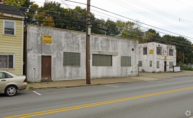
1865 Main St
Pittsburgh, PA
LOT 99X100X84 RR MAIN ST 1 & 2 STY BRK VEN & C B BLDG & TILE FRONT 1865
0168-M-00363-0000-00
Allegheny
Autorepair
Pennsylvania
C and X Area of minimal flood hazard, usually depicted on FIRMs as above the 500-year flood level.
363
2024
0.21 AC
2025
Northeast Pittsburgh
424000
Pittsburgh
NEARBY LISTINGS FOR SALE OR LEASE
DEMOGRAPHICS near 1865 Main St
1 mile
3 mile
5 mile
2025 Total Population
8,700
96,150
272,675
2030 Population
8,420
95,388
271,323
Pop Growth 2025-2030
(3.22%)
(0.79%)
(0.50%)
Average Age
43
41
40
2025 Total Households
4,022
47,193
124,682
HH Growth 2025-2030
(3.31%)
(0.91%)
(0.58%)
Median Household Inc
$78,493
$72,248
$68,542
Avg Household Size
2.10
2.00
2.00
2025 Avg HH Vehicles
1.00
1.00
1.00
Median Home Value
$282,499
$280,086
$267,266
Median Year Built
1947
1949
1952
Nearby Places
Map Layers
Map Styles
 Street
 Aerial
Transit
 Traffic
 Biking
Places
Listings with unknown addresses are not visible on the map
- Restaurants
- Banks
- Shops
- Fitness
- Groceries
PUBLIC TRANSPORTATION
COMMUTER RAIL
Drive
Walk
Distance
14 min
6.3 mi
AIRPORT
Pittsburgh International
Drive
Walk
Distance
Pittsburgh International
38 min
23.3 mi
Arnold Palmer Regional
Drive
Walk
Distance
Arnold Palmer Regional
67 min
45.2 mi
Nearby Properties
Address
Land Use
TOTAL SIZE
Lot Size
Zoning
Address
Land Use
TOTAL SIZE
Lot Size
Zoning
6.99 AC
Address
Land Use
TOTAL SIZE
Lot Size
Zoning
10.22 AC
Address
Land Use
TOTAL SIZE
Lot Size
Zoning
363.56 AC
Address
Land Use
TOTAL SIZE
Lot Size
Zoning
2.67 AC
Address
Land Use
TOTAL SIZE
Lot Size
Zoning
48.57 AC
Address
Land Use
TOTAL SIZE
Lot Size
Zoning
17.75 AC
Address
Land Use
TOTAL SIZE
Lot Size
Zoning
160.63 AC
Address
Land Use
TOTAL SIZE
Lot Size
Zoning
4.10 AC
Address
Land Use
TOTAL SIZE
Lot Size
Zoning
1.22 AC
Address
Land Use
TOTAL SIZE
Lot Size
Zoning
3.13 AC
Address
Land Use
TOTAL SIZE
Lot Size
Zoning
4,242 SF
115.01 AC
Address
Land Use
TOTAL SIZE
Lot Size
Zoning
0.67 AC
Address
Land Use
TOTAL SIZE
Lot Size
Zoning
2.69 AC
Address
Land Use
TOTAL SIZE
Lot Size
Zoning
91.02 AC
Address
Land Use
TOTAL SIZE
Lot Size
Zoning
82.74 AC
Address
Land Use
TOTAL SIZE
Lot Size
Zoning
3.91 AC
Address
Land Use
TOTAL SIZE
Lot Size
Zoning
1.52 AC
Address
Land Use
TOTAL SIZE
Lot Size
Zoning
1.34 AC
Address
Land Use
TOTAL SIZE
Lot Size
Zoning
28.95 AC
Address
Land Use
TOTAL SIZE
Lot Size
Zoning
301.92 AC
Address
Land Use
TOTAL SIZE
Lot Size
Zoning
Address
Land Use
TOTAL SIZE
Lot Size
Zoning
2.92 AC
Address
Land Use
TOTAL SIZE
Lot Size
Zoning
12.93 AC
Address
Land Use
TOTAL SIZE
Lot Size
Zoning
Address
Land Use
TOTAL SIZE
Lot Size
Zoning
10.45 AC
Address
Land Use
TOTAL SIZE
Lot Size
Zoning
33.39 AC
Address
Land Use
TOTAL SIZE
Lot Size
Zoning
0.86 AC
Address
Land Use
TOTAL SIZE
Lot Size
Zoning
Address
Land Use
TOTAL SIZE
Lot Size
Zoning
18.49 AC
Address
Land Use
TOTAL SIZE
Lot Size
Zoning
13.37 AC
The World's #1 Commercial Real Estate Marketplace
Connect with us
© 2026 CoStar Group
The information above has been obtained from sources believed reliable. While we do not doubt its accuracy we have not verified it and make no guarantee, warranty or representation about it. It is your responsibility to independently confirm its accuracy and completeness. Any projections, opinions, assumptions, or estimates used are for example only and do not represent the current or future performance of the property. The value of this transaction to you depends on tax and other factors which should be evaluated by your tax, financial, and legal advisors. You and your advisors should conduct a careful, independent investigation of the property to determine to your satisfaction the suitability of the property for your needs.