Property Record
1869 Southpark Blvd, Colonial Heights, VA 23834

NEARBY LISTINGS FOR SALE OR LEASE
Property Detail
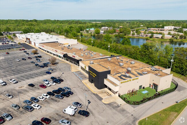
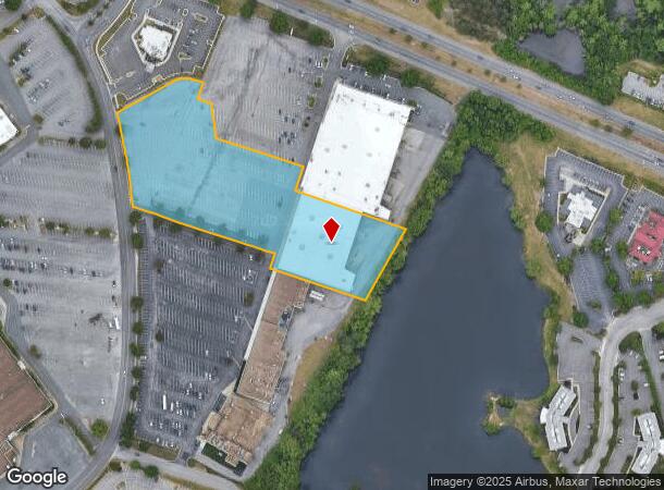
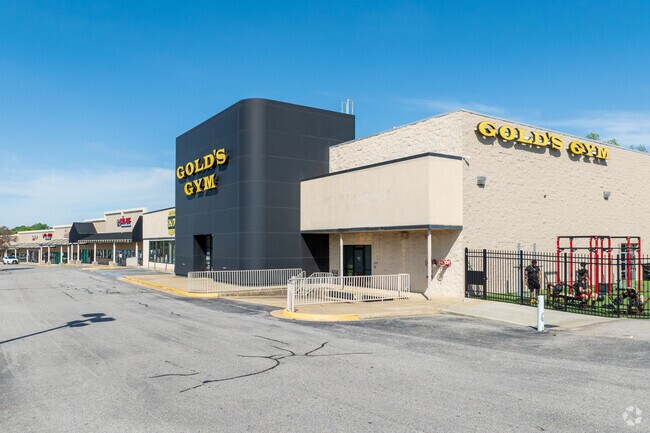
1869 Southpark Blvd
6820-47-00-019
Southpark
Wholesaleoutletdiscountstore
SUB: SOUTHPARK**SECTION: **BLOCK: 4.175 AC**LOT: PARCEL 19
X
Colonial Heights
51041C0345E
Virginia
2025
4.18 AC
2025
Colonial Heights
830100
Richmond VA
43,628 SF
Richmond, VA
DEMOGRAPHICS near 1869 Southpark Blvd
1 Mile
3 Mile
5 Mile
2024 Total Population
3,289
47,350
100,292
2029 Population
3,348
48,464
102,411
Pop Growth 2024-2029
+ 1.79%
+ 2.35%
+ 2.11%
Average Age
41
37
38
2024 Total Households
1,373
17,154
36,209
HH Growth 2024-2029
+ 1.89%
+ 2.37%
+ 2.01%
Median Household Inc
$74,040
$53,347
$55,040
Avg Household Size
2.40
2.20
2.40
2024 Avg HH Vehicles
2.00
2.00
2.00
Median Home Value
$169,529
$185,127
$178,040
Median Year Built
1962
1969
1973
Nearby Places
Map Layers
Map Styles
 Street
 Aerial
- Restaurants
- Banks
- Shops
- Fitness
- Groceries
PUBLIC TRANSPORTATION
COMMUTER RAIL
DRIVE
WALK
Distance
8 min
3.7 mi
AIRPORT
Richmond International
DRIVE
WALK
Distance
Richmond International
37 min
25.1 mi
Freight Ports
Virginia Port Authority - Richmond
DRIVE
WALK
Distance
Virginia Port Authority - Richmond
26 min
17.4 mi
SALE & LEASE HISTORY
LISTING DATE
SALE/LEASE

Sep 25, 2016
For Lease
Mar 19, 2018
For Sale
Nearby Properties
Address
Land Use
TOTAL SIZE
Lot Size
Zoning
Address
Land Use
TOTAL SIZE
Lot Size
Zoning
4,762.27 AC
Address
Land Use
TOTAL SIZE
Lot Size
Zoning
500 SF
390.12 AC
R7 - SINGL
Address
Land Use
TOTAL SIZE
Lot Size
Zoning
165,942 SF
0.57 AC
R7 - SINGL
Address
Land Use
TOTAL SIZE
Lot Size
Zoning
505,068 SF
60.92 AC
I2 - GEN I
Address
Land Use
TOTAL SIZE
Lot Size
Zoning
24,440 SF
16.58 AC
C4 - REGIO
Address
Land Use
TOTAL SIZE
Lot Size
Zoning
51,588 SF
13.86 AC
RMF - RES,
Address
Land Use
TOTAL SIZE
Lot Size
Zoning
498.93 AC
Address
Land Use
TOTAL SIZE
Lot Size
Zoning
209,515 SF
21.20 AC
B3
Address
Land Use
TOTAL SIZE
Lot Size
Zoning
95,944 SF
15.75 AC
C2 - NBHD
Address
Land Use
TOTAL SIZE
Lot Size
Zoning
188,368 SF
18.96 AC
B1
Address
Land Use
TOTAL SIZE
Lot Size
Zoning
119,151 SF
3.10 AC
M-1
Address
Land Use
TOTAL SIZE
Lot Size
Zoning
130,698 SF
10.78 AC
PUD
Address
Land Use
TOTAL SIZE
Lot Size
Zoning
223,211 SF
19.99 AC
B3
Address
Land Use
TOTAL SIZE
Lot Size
Zoning
57,011 SF
4.45 AC
BB
Address
Land Use
TOTAL SIZE
Lot Size
Zoning
140,000 SF
1 AC
999
Address
Land Use
TOTAL SIZE
Lot Size
Zoning
173,829 SF
13.73 AC
B2
Address
Land Use
TOTAL SIZE
Lot Size
Zoning
129,600 SF
12.21 AC
PUD
Address
Land Use
TOTAL SIZE
Lot Size
Zoning
100 SF
12.39 AC
R7 - SINGL
Address
Land Use
TOTAL SIZE
Lot Size
Zoning
128,848 SF
13.24 AC
B3
Address
Land Use
TOTAL SIZE
Lot Size
Zoning
92,701 SF
2.87 AC
B1
Address
Land Use
TOTAL SIZE
Lot Size
Zoning
89,734 SF
2.85 AC
B1
Address
Land Use
TOTAL SIZE
Lot Size
Zoning
86,387 SF
10.91 AC
B3
Address
Land Use
TOTAL SIZE
Lot Size
Zoning
6,284 SF
14.29 AC
11
Address
Land Use
TOTAL SIZE
Lot Size
Zoning
3,632 SF
11.30 AC
M-2
Address
Land Use
TOTAL SIZE
Lot Size
Zoning
37,809 SF
150 AC
R7 - SINGL
Address
Land Use
TOTAL SIZE
Lot Size
Zoning
68,438 SF
1.93 AC
Address
Land Use
TOTAL SIZE
Lot Size
Zoning
86,204 SF
54.43 AC
Address
Land Use
TOTAL SIZE
Lot Size
Zoning
140,340 SF
13.08 AC
B3
Address
Land Use
TOTAL SIZE
Lot Size
Zoning
97,419 SF
20 AC
R1
Address
Land Use
TOTAL SIZE
Lot Size
Zoning
72,250 SF
9.41 AC
PUD
The World's #1 Commercial Real Estate Marketplace
Connect with us
© 2026 CoStar Group
The information above has been obtained from sources believed reliable. While we do not doubt its accuracy we have not verified it and make no guarantee, warranty or representation about it. It is your responsibility to independently confirm its accuracy and completeness. Any projections, opinions, assumptions, or estimates used are for example only and do not represent the current or future performance of the property. The value of this transaction to you depends on tax and other factors which should be evaluated by your tax, financial, and legal advisors. You and your advisors should conduct a careful, independent investigation of the property to determine to your satisfaction the suitability of the property for your needs.