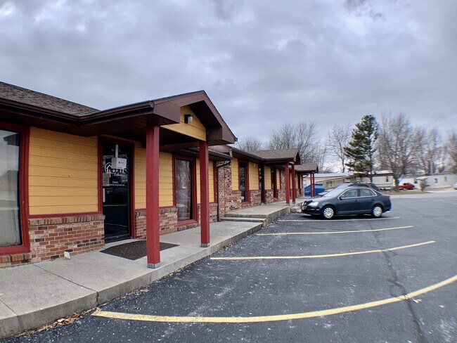
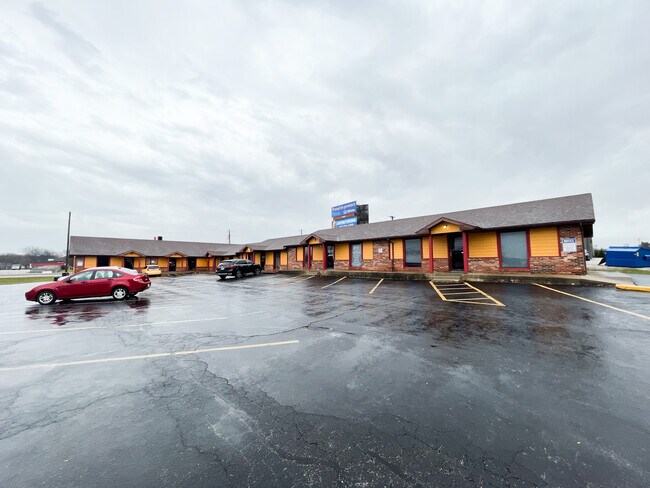
Property Record
1868 N Deffer Dr, Nixa, MO 65714

Property Detail
1868 N Deffer Dr
05-0.7-35-000-000-041.001
BEG. 300 W 362.5 S. OF NEC SE1/4 SE1/4, TH W 225, TH S 96.45, TH E 225, TH N 96.45 TO POB.
Storesoffices
Christian
B and X Area of moderate flood hazard, usually the area between the limits of the 100-year and 500-year floods.
Missouri
2024
0.50 AC
2025
West Christian County
020202
Springfield
7,232 SF
Springfield, MO
NEARBY LISTINGS FOR SALE OR LEASE
-
-
View all Nixa listings for lease on LoopNet.com
DEMOGRAPHICS near 1868 N Deffer Dr
1 mile
3 mile
5 mile
2025 Total Population
2,879
34,043
95,863
2030 Population
3,070
35,910
99,702
Pop Growth 2025-2030
+ 6.63%
+ 5.48%
+ 4.00%
Average Age
38
41
41
2025 Total Households
1,109
13,185
38,864
HH Growth 2025-2030
+ 6.67%
+ 5.48%
+ 3.92%
Median Household Inc
$68,756
$88,097
$79,928
Avg Household Size
2.60
2.50
2.40
2025 Avg HH Vehicles
2.00
2.00
2.00
Median Home Value
$287,667
$327,674
$303,317
Median Year Built
1995
1998
1995
Nearby Places
Map Layers
Map Styles
 Street
 Aerial
Layers
 Traffic
 Biking
Places
Listings with unknown addresses are not visible on the map
- Restaurants
- Banks
- Shops
- Fitness
- Groceries
PUBLIC TRANSPORTATION
AIRPORT
Springfield-Branson Ntl
Drive
Walk
Distance
Springfield-Branson Ntl
35 min
18.3 mi
SALE & LEASE HISTORY
LISTING DATE
SALE/LEASE

May 19, 2017
For Lease
Feb 10, 2020
For Sale
Dec 30, 2021
For Lease
Nearby Properties
Address
Land Use
TOTAL SIZE
Lot Size
Zoning
Address
Land Use
TOTAL SIZE
Lot Size
Zoning
192,607 SF
26.20 AC
Address
Land Use
TOTAL SIZE
Lot Size
Zoning
5,310 SF
12.27 AC
Address
Land Use
TOTAL SIZE
Lot Size
Zoning
4.12 AC
INC
Address
Land Use
TOTAL SIZE
Lot Size
Zoning
5.59 AC
INC
Address
Land Use
TOTAL SIZE
Lot Size
Zoning
5,360 SF
9.71 AC
Address
Land Use
TOTAL SIZE
Lot Size
Zoning
68,882 SF
39.87 AC
Address
Land Use
TOTAL SIZE
Lot Size
Zoning
126,557 SF
4.62 AC
INC
Address
Land Use
TOTAL SIZE
Lot Size
Zoning
125,218 SF
4.68 AC
INC
Address
Land Use
TOTAL SIZE
Lot Size
Zoning
30,049 SF
5.01 AC
Address
Land Use
TOTAL SIZE
Lot Size
Zoning
21,597 SF
18 AC
Address
Land Use
TOTAL SIZE
Lot Size
Zoning
4,894 SF
10.80 AC
Address
Land Use
TOTAL SIZE
Lot Size
Zoning
9,841 SF
7.17 AC
Address
Land Use
TOTAL SIZE
Lot Size
Zoning
92,462 SF
19.78 AC
Address
Land Use
TOTAL SIZE
Lot Size
Zoning
1,640 SF
24.20 AC
Address
Land Use
TOTAL SIZE
Lot Size
Zoning
6,875 SF
6.56 AC
Address
Land Use
TOTAL SIZE
Lot Size
Zoning
54,519 SF
18.56 AC
Address
Land Use
TOTAL SIZE
Lot Size
Zoning
53,597 SF
39.40 AC
Address
Land Use
TOTAL SIZE
Lot Size
Zoning
11,830 SF
10 AC
Address
Land Use
TOTAL SIZE
Lot Size
Zoning
71,436 SF
2.86 AC
INC
Address
Land Use
TOTAL SIZE
Lot Size
Zoning
15,785 SF
3.99 AC
Address
Land Use
TOTAL SIZE
Lot Size
Zoning
1,768 SF
9.46 AC
Address
Land Use
TOTAL SIZE
Lot Size
Zoning
18,055 SF
7 AC
Address
Land Use
TOTAL SIZE
Lot Size
Zoning
25,749 SF
39.26 AC
Address
Land Use
TOTAL SIZE
Lot Size
Zoning
2,400 SF
8.51 AC
Address
Land Use
TOTAL SIZE
Lot Size
Zoning
9,483 SF
4.71 AC
Address
Land Use
TOTAL SIZE
Lot Size
Zoning
14,500 SF
19.22 AC
Address
Land Use
TOTAL SIZE
Lot Size
Zoning
1.44 AC
INC
Address
Land Use
TOTAL SIZE
Lot Size
Zoning
13,940 SF
3.43 AC
Address
Land Use
TOTAL SIZE
Lot Size
Zoning
6,176 SF
5.45 AC
The World's #1 Commercial Real Estate Marketplace
Connect with us
© 2026 CoStar Group
The information above has been obtained from sources believed reliable. While we do not doubt its accuracy we have not verified it and make no guarantee, warranty or representation about it. It is your responsibility to independently confirm its accuracy and completeness. Any projections, opinions, assumptions, or estimates used are for example only and do not represent the current or future performance of the property. The value of this transaction to you depends on tax and other factors which should be evaluated by your tax, financial, and legal advisors. You and your advisors should conduct a careful, independent investigation of the property to determine to your satisfaction the suitability of the property for your needs.