Property Record
1868 Wiltsey Rd Se, Salem, OR 97306
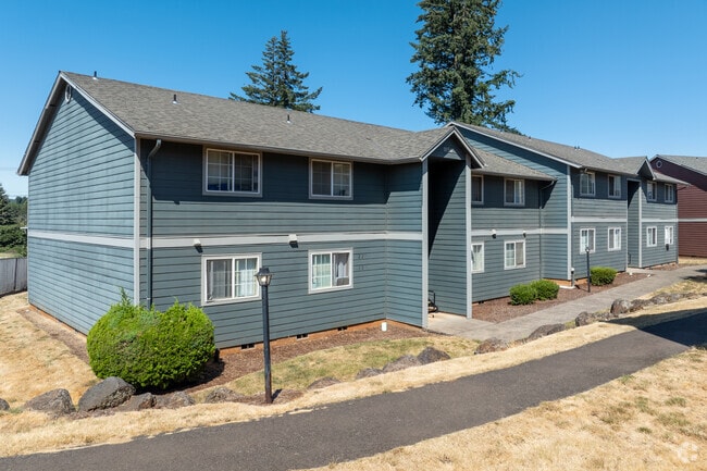

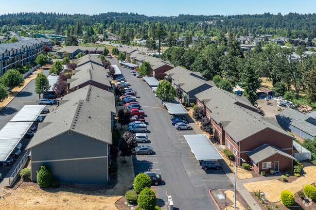
Property Detail
1868 Wiltsey Rd Se
575575
GRABENHORST FRUIT FARMS NO 3 LOT 22 ACRES 5.12
Multifamilydwelling
Marion
RM2
Oregon
B and X Area of moderate flood hazard, usually the area between the limits of the 100-year and 500-year floods.
22
2024
5.12 AC
2025
South Gateway
002002
Portland
96,322 SF
Salem, OR
NEARBY LISTINGS FOR SALE OR LEASE
DEMOGRAPHICS near 1868 Wiltsey Rd Se
1 mile
3 mile
5 mile
2025 Total Population
15,278
59,462
116,163
2030 Population
15,493
60,170
117,588
Pop Growth 2025-2030
+ 1.41%
+ 1.19%
+ 1.23%
Average Age
39
40
40
2025 Total Households
5,958
22,280
42,420
HH Growth 2025-2030
+ 1.43%
+ 1.26%
+ 1.28%
Median Household Inc
$84,266
$88,234
$79,849
Avg Household Size
2.50
2.50
2.50
2025 Avg HH Vehicles
2.00
2.00
2.00
Median Home Value
$451,715
$464,591
$452,811
Median Year Built
1995
1987
1979
Nearby Places
Map Layers
Map Styles
 Street
 Aerial
Layers
 Traffic
 Biking
Places
Listings with unknown addresses are not visible on the map
- Restaurants
- Banks
- Shops
- Fitness
- Groceries
PUBLIC TRANSPORTATION
COMMUTER RAIL
Salem (Amtrak Cascades - Amtrak, Coast Starlight - Amtrak)
Drive
Walk
Distance
Salem (Amtrak Cascades - Amtrak, Coast Starlight - Amtrak)
9 min
4.8 mi
Freight Ports
Port of Portland
Drive
Walk
Distance
Port of Portland
72 min
55.5 mi
Nearby Properties
Address
Land Use
TOTAL SIZE
Lot Size
Zoning
Address
Land Use
TOTAL SIZE
Lot Size
Zoning
412,248 SF
27.80 AC
Address
Land Use
TOTAL SIZE
Lot Size
Zoning
158,880 SF
8.80 AC
RM2; RM1;
Address
Land Use
TOTAL SIZE
Lot Size
Zoning
62,708 SF
30.21 AC
PH
Address
Land Use
TOTAL SIZE
Lot Size
Zoning
114,647 SF
5.72 AC
RM2; RM1
Address
Land Use
TOTAL SIZE
Lot Size
Zoning
102,124 SF
10.53 AC
CR
Address
Land Use
TOTAL SIZE
Lot Size
Zoning
193,237 SF
9.98 AC
IG
Address
Land Use
TOTAL SIZE
Lot Size
Zoning
1,769,016 SF
20.58 AC
CR
Address
Land Use
TOTAL SIZE
Lot Size
Zoning
108,723 SF
7.12 AC
IC
Address
Land Use
TOTAL SIZE
Lot Size
Zoning
204,178 SF
10.43 AC
RM2; PA
Address
Land Use
TOTAL SIZE
Lot Size
Zoning
Address
Land Use
TOTAL SIZE
Lot Size
Zoning
118,239 SF
10.69 AC
IG
Address
Land Use
TOTAL SIZE
Lot Size
Zoning
140,505 SF
5.84 AC
RM2; RS
Address
Land Use
TOTAL SIZE
Lot Size
Zoning
74,710 SF
9.83 AC
PS
Address
Land Use
TOTAL SIZE
Lot Size
Zoning
72,325 SF
7.79 AC
IBC
Address
Land Use
TOTAL SIZE
Lot Size
Zoning
144,616 SF
7.07 AC
RM2; CO
Address
Land Use
TOTAL SIZE
Lot Size
Zoning
143,684 SF
9.43 AC
CR; RS
Address
Land Use
TOTAL SIZE
Lot Size
Zoning
174,632 SF
4.58 AC
CO
Address
Land Use
TOTAL SIZE
Lot Size
Zoning
120,648 SF
16.05 AC
CR
Address
Land Use
TOTAL SIZE
Lot Size
Zoning
Address
Land Use
TOTAL SIZE
Lot Size
Zoning
Address
Land Use
TOTAL SIZE
Lot Size
Zoning
Address
Land Use
TOTAL SIZE
Lot Size
Zoning
124,947 SF
6.27 AC
RM2
Address
Land Use
TOTAL SIZE
Lot Size
Zoning
109,373 SF
4.30 AC
FMU
Address
Land Use
TOTAL SIZE
Lot Size
Zoning
130,360 SF
6.34 AC
RM2
Address
Land Use
TOTAL SIZE
Lot Size
Zoning
115,612 SF
5.87 AC
RM2
Address
Land Use
TOTAL SIZE
Lot Size
Zoning
132,655 SF
6.78 AC
FMU
Address
Land Use
TOTAL SIZE
Lot Size
Zoning
51,473 SF
5.01 AC
CO
Address
Land Use
TOTAL SIZE
Lot Size
Zoning
114,559 SF
5.26 AC
RM2
The World's #1 Commercial Real Estate Marketplace
Connect with us
© 2026 CoStar Group
The information above has been obtained from sources believed reliable. While we do not doubt its accuracy we have not verified it and make no guarantee, warranty or representation about it. It is your responsibility to independently confirm its accuracy and completeness. Any projections, opinions, assumptions, or estimates used are for example only and do not represent the current or future performance of the property. The value of this transaction to you depends on tax and other factors which should be evaluated by your tax, financial, and legal advisors. You and your advisors should conduct a careful, independent investigation of the property to determine to your satisfaction the suitability of the property for your needs.