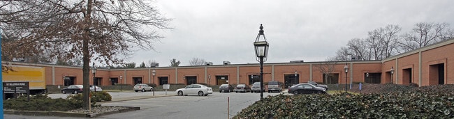
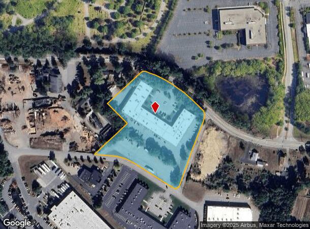
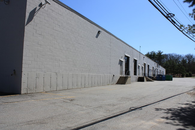
Property Record
187 Billerica Rd, Chelmsford, MA 01824
Current Lease Availabilities
NEARBY LISTINGS FOR SALE OR LEASE
Property Detail
187 Billerica Rd
CHEL-000086-000331-000001
Chelmsford
Industrialgeneral
Middlesex
X
Massachusetts
25017C0252G
1
2025
5.12 AC
2025
Lowell/Chelmsford
317102
Boston
49,600 SF
Boston-Cambridge-Newton, MA-NH
DEMOGRAPHICS near 187 Billerica Rd
1 Mile
3 Mile
5 Mile
2024 Total Population
4,182
77,337
198,047
2029 Population
4,190
76,297
195,113
Pop Growth 2024-2029
+ 0.19%
(1.34%)
(1.48%)
Average Age
42
39
40
2024 Total Households
1,698
27,375
72,612
HH Growth 2024-2029
+ 0.24%
(1.36%)
(1.53%)
Median Household Inc
$112,421
$91,322
$87,398
Avg Household Size
2.40
2.70
2.60
2024 Avg HH Vehicles
2.00
2.00
2.00
Median Home Value
$563,191
$436,893
$438,087
Median Year Built
1966
1962
1964
Nearby Places
- Restaurants
- Banks
- Shops
- Fitness
- Groceries
PUBLIC TRANSPORTATION
COMMUTER RAIL
North Billerica (Lowell Line - Massachusetts Bay Transportation Authority Commuter Rail (Purple Line))
DRIVE
WALK
Distance
North Billerica (Lowell Line - Massachusetts Bay Transportation Authority Commuter Rail (Purple Line))
7 min
3.4 mi
Lowell (Lowell Line - Massachusetts Bay Transportation Authority Commuter Rail (Purple Line))
DRIVE
WALK
Distance
Lowell (Lowell Line - Massachusetts Bay Transportation Authority Commuter Rail (Purple Line))
7 min
3.8 mi
AIRPORT
General Edward Lawrence Logan International
DRIVE
WALK
Distance
General Edward Lawrence Logan International
45 min
30.0 mi
Manchester Boston Regional
DRIVE
WALK
Distance
Manchester Boston Regional
46 min
31.4 mi
Freight Ports
Port of Boston
DRIVE
WALK
Distance
Port of Boston
46 min
29.7 mi
Nearby Properties
Address
Land Use
TOTAL SIZE
Lot Size
Zoning
Address
Land Use
TOTAL SIZE
Lot Size
Zoning
14.73 AC
HRC
Address
Land Use
TOTAL SIZE
Lot Size
Zoning
275,574 SF
6.66 AC
HRCO
Address
Land Use
TOTAL SIZE
Lot Size
Zoning
Address
Land Use
TOTAL SIZE
Lot Size
Zoning
11.45 AC
TTF
Address
Land Use
TOTAL SIZE
Lot Size
Zoning
15.16 AC
SMF
Address
Land Use
TOTAL SIZE
Lot Size
Zoning
174 SF
IA
Address
Land Use
TOTAL SIZE
Lot Size
Zoning
396,990 SF
48.84 AC
IH
Address
Land Use
TOTAL SIZE
Lot Size
Zoning
19.97 AC
SSF
Address
Land Use
TOTAL SIZE
Lot Size
Zoning
269,952 SF
18.11 AC
P
Address
Land Use
TOTAL SIZE
Lot Size
Zoning
380,132 SF
35.87 AC
5
Address
Land Use
TOTAL SIZE
Lot Size
Zoning
262,607 SF
4.33 AC
INST
Address
Land Use
TOTAL SIZE
Lot Size
Zoning
7.18 AC
SMF
Address
Land Use
TOTAL SIZE
Lot Size
Zoning
137,235 SF
12.77 AC
5
Address
Land Use
TOTAL SIZE
Lot Size
Zoning
38.26 AC
P
Address
Land Use
TOTAL SIZE
Lot Size
Zoning
26.65 AC
IA
Address
Land Use
TOTAL SIZE
Lot Size
Zoning
7.41 AC
CB
Address
Land Use
TOTAL SIZE
Lot Size
Zoning
4.85 AC
IA
Address
Land Use
TOTAL SIZE
Lot Size
Zoning
22.30 AC
IA
Address
Land Use
TOTAL SIZE
Lot Size
Zoning
3,954 SF
13.42 AC
IA
Address
Land Use
TOTAL SIZE
Lot Size
Zoning
95,745 SF
20.32 AC
TMF
Address
Land Use
TOTAL SIZE
Lot Size
Zoning
18.50 AC
CC
Address
Land Use
TOTAL SIZE
Lot Size
Zoning
2,856 SF
11.82 AC
SMF
Address
Land Use
TOTAL SIZE
Lot Size
Zoning
6.93 AC
SMU
Address
Land Use
TOTAL SIZE
Lot Size
Zoning
355,104 SF
Address
Land Use
TOTAL SIZE
Lot Size
Zoning
241,545 SF
18.28 AC
CC
Address
Land Use
TOTAL SIZE
Lot Size
Zoning
9.48 AC
RB
Address
Land Use
TOTAL SIZE
Lot Size
Zoning
13.23 AC
Address
Land Use
TOTAL SIZE
Lot Size
Zoning
101,618 SF
1.52 AC
UMU
Address
Land Use
TOTAL SIZE
Lot Size
Zoning
148,890 SF
6.99 AC
5
Address
Land Use
TOTAL SIZE
Lot Size
Zoning
3.85 AC
SMF
The World's #1 Commercial Real Estate Marketplace
Connect with us
© 2025 CoStar Group
The information above has been obtained from sources believed reliable. While we do not doubt its accuracy we have not verified it and make no guarantee, warranty or representation about it. It is your responsibility to independently confirm its accuracy and completeness. Any projections, opinions, assumptions, or estimates used are for example only and do not represent the current or future performance of the property. The value of this transaction to you depends on tax and other factors which should be evaluated by your tax, financial, and legal advisors. You and your advisors should conduct a careful, independent investigation of the property to determine to your satisfaction the suitability of the property for your needs.