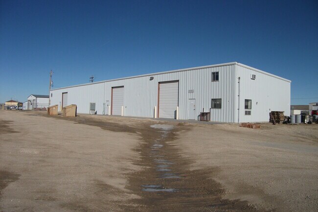
Property Record
187 Gusher St, Evansville, WY 82636

NEARBY LISTINGS FOR SALE OR LEASE
Property Detail
187 Gusher St
Casper, WY
Brooks Hat Six Ind Pk
33-78-04-3-0-300800
BROOKS-HAT SIX IND PK BLK 1 LOT 8 COMMERICAL
Warehouse
Natrona
X
Wyoming
56025C2030E
8
2024
2.09 AC
2025
I-25 Corridor/Casper
001401
Other Market Areas
6,000 SF
DEMOGRAPHICS near 187 Gusher St
1 Mile
3 Mile
5 Mile
2024 Total Population
675
7,956
28,953
2029 Population
682
8,106
29,413
Pop Growth 2024-2029
+ 1.04%
+ 1.89%
+ 1.59%
Average Age
42
40
40
2024 Total Households
281
3,166
12,075
HH Growth 2024-2029
+ 1.07%
+ 1.99%
+ 1.63%
Median Household Inc
$83,244
$78,844
$64,958
Avg Household Size
2.40
2.50
2.30
2024 Avg HH Vehicles
2.00
2.00
2.00
Median Home Value
$520,115
$339,359
$243,796
Median Year Built
1987
1998
1977
Nearby Places
Map Layers
Map Styles
 Street
 Aerial
- Restaurants
- Banks
- Shops
- Fitness
- Groceries
PUBLIC TRANSPORTATION
AIRPORT
Casper/Natrona County International
DRIVE
WALK
Distance
Casper/Natrona County International
22 min
14.8 mi
SALE & LEASE HISTORY
LISTING DATE
SALE/LEASE

Sep 07, 2017
For Lease
May 14, 2020
For Lease
Nearby Properties
Address
Land Use
TOTAL SIZE
Lot Size
Zoning
Address
Land Use
TOTAL SIZE
Lot Size
Zoning
4,660 SF
13.18 AC
Address
Land Use
TOTAL SIZE
Lot Size
Zoning
23,532 SF
10.30 AC
Address
Land Use
TOTAL SIZE
Lot Size
Zoning
50,537 SF
8 AC
Address
Land Use
TOTAL SIZE
Lot Size
Zoning
38,736 SF
8.91 AC
Address
Land Use
TOTAL SIZE
Lot Size
Zoning
120,426 SF
15.86 AC
Address
Land Use
TOTAL SIZE
Lot Size
Zoning
102,996 SF
4.81 AC
Address
Land Use
TOTAL SIZE
Lot Size
Zoning
585,921 SF
58.85 AC
Address
Land Use
TOTAL SIZE
Lot Size
Zoning
176,027 SF
17.49 AC
Address
Land Use
TOTAL SIZE
Lot Size
Zoning
52,040 SF
13.51 AC
Address
Land Use
TOTAL SIZE
Lot Size
Zoning
55,754 SF
1.23 AC
Address
Land Use
TOTAL SIZE
Lot Size
Zoning
95,756 SF
3.15 AC
Address
Land Use
TOTAL SIZE
Lot Size
Zoning
206,796 SF
18.06 AC
Address
Land Use
TOTAL SIZE
Lot Size
Zoning
89,995 SF
6.68 AC
Address
Land Use
TOTAL SIZE
Lot Size
Zoning
68,887 SF
8.02 AC
Address
Land Use
TOTAL SIZE
Lot Size
Zoning
110,360 SF
12.85 AC
Address
Land Use
TOTAL SIZE
Lot Size
Zoning
68,174 SF
3.86 AC
Address
Land Use
TOTAL SIZE
Lot Size
Zoning
29,040 SF
5.35 AC
Address
Land Use
TOTAL SIZE
Lot Size
Zoning
119,046 SF
12.71 AC
Address
Land Use
TOTAL SIZE
Lot Size
Zoning
57,037 SF
1.01 AC
Address
Land Use
TOTAL SIZE
Lot Size
Zoning
45,140 SF
7.84 AC
Address
Land Use
TOTAL SIZE
Lot Size
Zoning
95,941 SF
7.97 AC
Address
Land Use
TOTAL SIZE
Lot Size
Zoning
39,860 SF
6.23 AC
Address
Land Use
TOTAL SIZE
Lot Size
Zoning
61,226 SF
2.04 AC
Address
Land Use
TOTAL SIZE
Lot Size
Zoning
24,360 SF
1.65 AC
Address
Land Use
TOTAL SIZE
Lot Size
Zoning
55,364 SF
1.62 AC
Address
Land Use
TOTAL SIZE
Lot Size
Zoning
24,975 SF
3.56 AC
Address
Land Use
TOTAL SIZE
Lot Size
Zoning
80,307 SF
7.54 AC
Address
Land Use
TOTAL SIZE
Lot Size
Zoning
2,400 SF
23.35 AC
Address
Land Use
TOTAL SIZE
Lot Size
Zoning
35,513 SF
6.53 AC
Address
Land Use
TOTAL SIZE
Lot Size
Zoning
52,124 SF
4.34 AC
The World's #1 Commercial Real Estate Marketplace
Connect with us
© 2026 CoStar Group
The information above has been obtained from sources believed reliable. While we do not doubt its accuracy we have not verified it and make no guarantee, warranty or representation about it. It is your responsibility to independently confirm its accuracy and completeness. Any projections, opinions, assumptions, or estimates used are for example only and do not represent the current or future performance of the property. The value of this transaction to you depends on tax and other factors which should be evaluated by your tax, financial, and legal advisors. You and your advisors should conduct a careful, independent investigation of the property to determine to your satisfaction the suitability of the property for your needs.