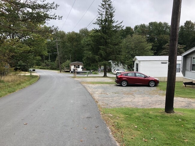
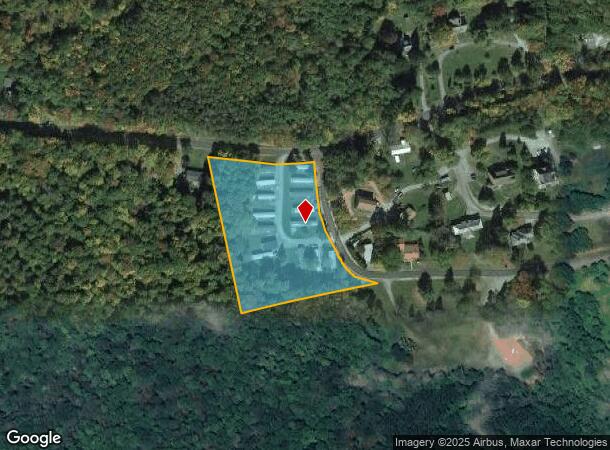
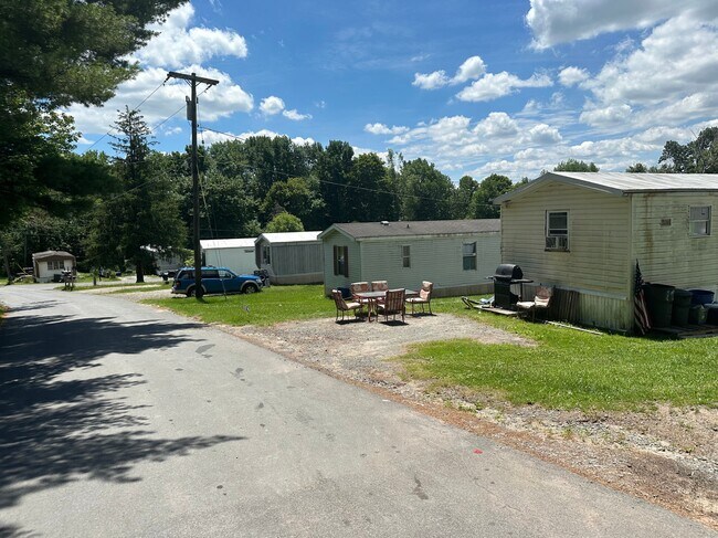
Property Record
187 Loomis Rd, Liberty, NY 12754
NEARBY LISTINGS FOR SALE OR LEASE
-
-
View all Liberty listings for sale on LoopNet.com
Property Detail
187 Loomis Rd
3689-035-0-0001-032-002
2003 15 SITES/BLDG/14 RM5
Mobilehomepark
Sullivan
X
New York
36105C0292F
32.002
2025
3.25 AC
2024
Hudson Valley Area
950500
Other Market Areas
880 SF
DEMOGRAPHICS near 187 Loomis Rd
1 Mile
3 Mile
5 Mile
2024 Total Population
557
7,429
10,606
2029 Population
563
7,670
10,933
Pop Growth 2024-2029
+ 1.08%
+ 3.24%
+ 3.08%
Average Age
39
39
41
2024 Total Households
217
2,767
4,100
HH Growth 2024-2029
+ 1.38%
+ 3.51%
+ 3.37%
Median Household Inc
$29,999
$45,937
$46,439
Avg Household Size
2.50
2.50
2.40
2024 Avg HH Vehicles
1.00
1.00
2.00
Median Home Value
$126,875
$140,758
$161,370
Median Year Built
1948
1958
1963
Nearby Places
- Restaurants
- Banks
- Shops
- Fitness
- Groceries
SALE & LEASE HISTORY
LISTING DATE
SALE/LEASE

Sep 23, 2024
For Sale
Jul 17, 2020
For Sale
Nearby Properties
Address
Land Use
TOTAL SIZE
Lot Size
Zoning
Address
Land Use
TOTAL SIZE
Lot Size
Zoning
98,138 SF
47.80 AC
C
Address
Land Use
TOTAL SIZE
Lot Size
Zoning
6,832 SF
31.50 AC
RD
Address
Land Use
TOTAL SIZE
Lot Size
Zoning
108,721 SF
3.93 AC
M
Address
Land Use
TOTAL SIZE
Lot Size
Zoning
58,675 SF
6.46 AC
C
Address
Land Use
TOTAL SIZE
Lot Size
Zoning
1,042,540 SF
14.62 AC
C
Address
Land Use
TOTAL SIZE
Lot Size
Zoning
21,600 SF
7.10 AC
SC
Address
Land Use
TOTAL SIZE
Lot Size
Zoning
20,777 SF
118.90 AC
RD2
Address
Land Use
TOTAL SIZE
Lot Size
Zoning
3,196 SF
80.90 AC
RD2
Address
Land Use
TOTAL SIZE
Lot Size
Zoning
14,658 SF
5.67 AC
M
Address
Land Use
TOTAL SIZE
Lot Size
Zoning
4,230 SF
59.74 AC
C
Address
Land Use
TOTAL SIZE
Lot Size
Zoning
6,870 SF
61.41 AC
RS
Address
Land Use
TOTAL SIZE
Lot Size
Zoning
15,401 SF
62.56 AC
SC
Address
Land Use
TOTAL SIZE
Lot Size
Zoning
20,816 SF
1.90 AC
C
Address
Land Use
TOTAL SIZE
Lot Size
Zoning
12,360 SF
161.74 AC
RD
Address
Land Use
TOTAL SIZE
Lot Size
Zoning
16,176 SF
20.16 AC
RD
Address
Land Use
TOTAL SIZE
Lot Size
Zoning
23,768 SF
2.24 AC
C
Address
Land Use
TOTAL SIZE
Lot Size
Zoning
6,048 SF
105.58 AC
RD2
Address
Land Use
TOTAL SIZE
Lot Size
Zoning
5,460 SF
65 AC
RD
Address
Land Use
TOTAL SIZE
Lot Size
Zoning
2,131 SF
93.10 AC
RD2
Address
Land Use
TOTAL SIZE
Lot Size
Zoning
3,808 SF
65.70 AC
RD
Address
Land Use
TOTAL SIZE
Lot Size
Zoning
18,472 SF
1.33 AC
C
Address
Land Use
TOTAL SIZE
Lot Size
Zoning
42,371 SF
1.20 AC
C
Address
Land Use
TOTAL SIZE
Lot Size
Zoning
22,338 SF
3 AC
C
Address
Land Use
TOTAL SIZE
Lot Size
Zoning
11,627 SF
1.95 AC
M
Address
Land Use
TOTAL SIZE
Lot Size
Zoning
18.96 AC
RD
Address
Land Use
TOTAL SIZE
Lot Size
Zoning
8,064 SF
7 AC
C
Address
Land Use
TOTAL SIZE
Lot Size
Zoning
924 SF
50.41 AC
AC
Address
Land Use
TOTAL SIZE
Lot Size
Zoning
1,344 SF
116.70 AC
RD
Address
Land Use
TOTAL SIZE
Lot Size
Zoning
10,320 SF
27.50 AC
RD2
Address
Land Use
TOTAL SIZE
Lot Size
Zoning
17,825 SF
1.82 AC
C
The World's #1 Commercial Real Estate Marketplace
Connect with us
© 2025 CoStar Group
The information above has been obtained from sources believed reliable. While we do not doubt its accuracy we have not verified it and make no guarantee, warranty or representation about it. It is your responsibility to independently confirm its accuracy and completeness. Any projections, opinions, assumptions, or estimates used are for example only and do not represent the current or future performance of the property. The value of this transaction to you depends on tax and other factors which should be evaluated by your tax, financial, and legal advisors. You and your advisors should conduct a careful, independent investigation of the property to determine to your satisfaction the suitability of the property for your needs.