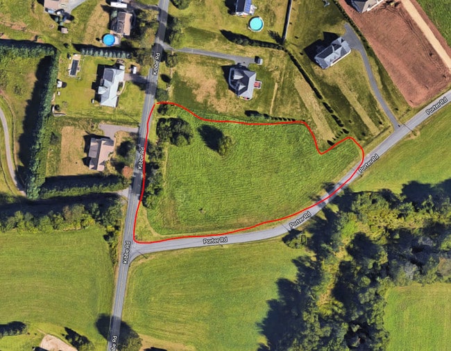
Property Record
187 Porter Rd, Ellington, CT 06029

Save to a Folder
{{folder.Name}}
{{folder.ListingIds.length}} Properties
{{folder.ListingIds.length}} Property
Create a New Folder
Property Detail
187 Porter Rd
Hartford-West Hartford-East Hartford, CT
TOLLAND
ELLI-000122-000030-000006
Connecticut
Residentialacreage
6
RAR
2.33 AC
2025
Tolland County
2025
Hartford
535200
NEARBY LISTINGS FOR SALE OR LEASE
DEMOGRAPHICS near 187 Porter Rd
1 mile
3 mile
5 mile
2025 Total Population
1,565
8,571
44,152
2030 Population
1,590
8,792
45,217
Pop Growth 2025-2030
+ 1.60%
+ 2.58%
+ 2.41%
Average Age
41
42
42
2025 Total Households
613
3,350
18,334
HH Growth 2025-2030
+ 1.47%
+ 2.66%
+ 2.44%
Median Household Inc
$103,226
$122,892
$98,080
Avg Household Size
2.50
2.50
2.40
2025 Avg HH Vehicles
2.00
3.00
2.00
Median Home Value
$353,478
$374,472
$348,145
Median Year Built
1979
1981
1972
Nearby Places
Map Layers
Map Styles
 Street
 Aerial
Layers
 Traffic
 Biking
Places
Listings with unknown addresses are not visible on the map
- Restaurants
- Banks
- Shops
- Fitness
- Groceries
PUBLIC TRANSPORTATION
AIRPORT
Bradley International
Drive
Walk
Distance
Bradley International
40 min
19.8 mi
Freight Ports
Port of New Haven
Drive
Walk
Distance
Port of New Haven
75 min
55.9 mi
SALE & LEASE HISTORY
LISTING DATE
SALE/LEASE

Feb 12, 2018
For Sale
Nearby Properties
Address
Land Use
TOTAL SIZE
Lot Size
Zoning
Address
Land Use
TOTAL SIZE
Lot Size
Zoning
59.25 AC
C
Address
Land Use
TOTAL SIZE
Lot Size
Zoning
29.97 AC
PC
Address
Land Use
TOTAL SIZE
Lot Size
Zoning
47.78 AC
RAR
Address
Land Use
TOTAL SIZE
Lot Size
Zoning
24.66 AC
C
Address
Land Use
TOTAL SIZE
Lot Size
Zoning
19.38 AC
C
Address
Land Use
TOTAL SIZE
Lot Size
Zoning
20.27 AC
MF
Address
Land Use
TOTAL SIZE
Lot Size
Zoning
18.84 AC
MF
Address
Land Use
TOTAL SIZE
Lot Size
Zoning
13.05 AC
PC
Address
Land Use
TOTAL SIZE
Lot Size
Zoning
24,465 SF
1.89 AC
R
Address
Land Use
TOTAL SIZE
Lot Size
Zoning
45,680 SF
8.11 AC
PC
Address
Land Use
TOTAL SIZE
Lot Size
Zoning
9.76 AC
MF
Address
Land Use
TOTAL SIZE
Lot Size
Zoning
10,847 SF
5 AC
PC
Address
Land Use
TOTAL SIZE
Lot Size
Zoning
4.25 AC
R
Address
Land Use
TOTAL SIZE
Lot Size
Zoning
5 AC
C
Address
Land Use
TOTAL SIZE
Lot Size
Zoning
6.54 AC
C
Address
Land Use
TOTAL SIZE
Lot Size
Zoning
9.18 AC
C
Address
Land Use
TOTAL SIZE
Lot Size
Zoning
5.74 AC
PC
Address
Land Use
TOTAL SIZE
Lot Size
Zoning
27,660 SF
6.53 AC
PC
Address
Land Use
TOTAL SIZE
Lot Size
Zoning
60,540 SF
4.20 AC
I
Address
Land Use
TOTAL SIZE
Lot Size
Zoning
21.59 AC
RAR
Address
Land Use
TOTAL SIZE
Lot Size
Zoning
11,692 SF
6.65 AC
PC
Address
Land Use
TOTAL SIZE
Lot Size
Zoning
123.07 AC
A-1
Address
Land Use
TOTAL SIZE
Lot Size
Zoning
8.14 AC
C
Address
Land Use
TOTAL SIZE
Lot Size
Zoning
4.30 AC
I
Address
Land Use
TOTAL SIZE
Lot Size
Zoning
30,601 SF
12.98 AC
I
Address
Land Use
TOTAL SIZE
Lot Size
Zoning
34.65 AC
I
Address
Land Use
TOTAL SIZE
Lot Size
Zoning
10,579 SF
2.74 AC
R
Address
Land Use
TOTAL SIZE
Lot Size
Zoning
36,927 SF
4.29 AC
C
Address
Land Use
TOTAL SIZE
Lot Size
Zoning
105.61 AC
A-1
Address
Land Use
TOTAL SIZE
Lot Size
Zoning
125 AC
I
The World's #1 Commercial Real Estate Marketplace
Connect with us
© 2026 CoStar Group
The information above has been obtained from sources believed reliable. While we do not doubt its accuracy we have not verified it and make no guarantee, warranty or representation about it. It is your responsibility to independently confirm its accuracy and completeness. Any projections, opinions, assumptions, or estimates used are for example only and do not represent the current or future performance of the property. The value of this transaction to you depends on tax and other factors which should be evaluated by your tax, financial, and legal advisors. You and your advisors should conduct a careful, independent investigation of the property to determine to your satisfaction the suitability of the property for your needs.