Property Record
187 W Ohio Ave, Dover, OH 44622
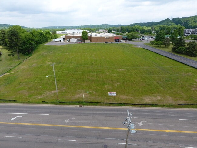

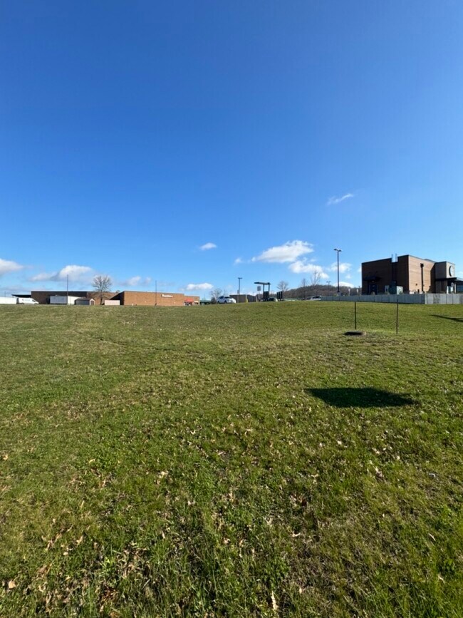
Property Detail
187 W Ohio Ave
New Philadelphia-Dover, OH
2 9 2 PR 49 2.1135A
1505022012
TUSCARAWAS
Commercialacreage
Ohio
B and X Area of moderate flood hazard, usually the area between the limits of the 100-year and 500-year floods.
2.11 AC
2025
Ohio North Area
2025
Other Market Areas
020600
NEARBY LISTINGS FOR SALE OR LEASE
DEMOGRAPHICS near 187 W Ohio Ave
1 mile
3 mile
5 mile
2025 Total Population
2,672
15,492
34,173
2030 Population
2,655
15,419
34,149
Pop Growth 2025-2030
(0.64%)
(0.47%)
(0.07%)
Average Age
45
43
42
2025 Total Households
1,114
6,159
14,094
HH Growth 2025-2030
(0.63%)
(0.54%)
(0.10%)
Median Household Inc
$79,619
$67,199
$63,824
Avg Household Size
2.30
2.40
2.30
2025 Avg HH Vehicles
2.00
2.00
2.00
Median Home Value
$250,189
$215,612
$198,641
Median Year Built
1972
1967
1965
Nearby Places
Map Layers
Map Styles
 Street
 Aerial
Layers
 Traffic
 Biking
Places
Listings with unknown addresses are not visible on the map
- Restaurants
- Banks
- Shops
- Fitness
- Groceries
PUBLIC TRANSPORTATION
AIRPORT
Akron-Canton Regional
Drive
Walk
Distance
Akron-Canton Regional
35 min
30.3 mi
Freight Ports
Port of Toledo
Drive
Walk
Distance
Port of Toledo
206 min
177.6 mi
SALE & LEASE HISTORY
LISTING DATE
SALE/LEASE

Nov 05, 2025
For Sale
Mar 25, 2024
For Sale
Jun 23, 2020
For Sale
Aug 07, 2019
For Lease
Nearby Properties
Address
Land Use
TOTAL SIZE
Lot Size
Zoning
Address
Land Use
TOTAL SIZE
Lot Size
Zoning
100,419 SF
3.59 AC
Address
Land Use
TOTAL SIZE
Lot Size
Zoning
6.57 AC
Address
Land Use
TOTAL SIZE
Lot Size
Zoning
67,343 SF
6.73 AC
Address
Land Use
TOTAL SIZE
Lot Size
Zoning
143,819 SF
6.57 AC
Address
Land Use
TOTAL SIZE
Lot Size
Zoning
38,869 SF
2.98 AC
Address
Land Use
TOTAL SIZE
Lot Size
Zoning
4,021,013 SF
12 AC
Address
Land Use
TOTAL SIZE
Lot Size
Zoning
22,049 SF
2.70 AC
Address
Land Use
TOTAL SIZE
Lot Size
Zoning
19,460 SF
57.15 AC
Address
Land Use
TOTAL SIZE
Lot Size
Zoning
10.01 AC
Address
Land Use
TOTAL SIZE
Lot Size
Zoning
87,559 SF
11.85 AC
Address
Land Use
TOTAL SIZE
Lot Size
Zoning
2 SF
12.34 AC
Address
Land Use
TOTAL SIZE
Lot Size
Zoning
86,410 SF
10.85 AC
Address
Land Use
TOTAL SIZE
Lot Size
Zoning
12,425 SF
2.53 AC
Address
Land Use
TOTAL SIZE
Lot Size
Zoning
46,624 SF
8.32 AC
Address
Land Use
TOTAL SIZE
Lot Size
Zoning
42,760 SF
7.11 AC
Address
Land Use
TOTAL SIZE
Lot Size
Zoning
129,913 SF
10.01 AC
Address
Land Use
TOTAL SIZE
Lot Size
Zoning
115,750 SF
18.54 AC
Address
Land Use
TOTAL SIZE
Lot Size
Zoning
40,132 SF
3.57 AC
Address
Land Use
TOTAL SIZE
Lot Size
Zoning
14,906 SF
5.42 AC
Address
Land Use
TOTAL SIZE
Lot Size
Zoning
45,276 SF
1.51 AC
Address
Land Use
TOTAL SIZE
Lot Size
Zoning
14,454 SF
3.52 AC
Address
Land Use
TOTAL SIZE
Lot Size
Zoning
1 SF
21.63 AC
Address
Land Use
TOTAL SIZE
Lot Size
Zoning
23,467 SF
5.41 AC
Address
Land Use
TOTAL SIZE
Lot Size
Zoning
36,354 SF
3.36 AC
Address
Land Use
TOTAL SIZE
Lot Size
Zoning
50,661 SF
28.95 AC
Address
Land Use
TOTAL SIZE
Lot Size
Zoning
62,880 SF
4.11 AC
Address
Land Use
TOTAL SIZE
Lot Size
Zoning
28,406 SF
3.24 AC
Address
Land Use
TOTAL SIZE
Lot Size
Zoning
17,840 SF
2.36 AC
Address
Land Use
TOTAL SIZE
Lot Size
Zoning
25,365 SF
1.66 AC
Address
Land Use
TOTAL SIZE
Lot Size
Zoning
19,110 SF
2 AC
The World's #1 Commercial Real Estate Marketplace
Connect with us
© 2026 CoStar Group
The information above has been obtained from sources believed reliable. While we do not doubt its accuracy we have not verified it and make no guarantee, warranty or representation about it. It is your responsibility to independently confirm its accuracy and completeness. Any projections, opinions, assumptions, or estimates used are for example only and do not represent the current or future performance of the property. The value of this transaction to you depends on tax and other factors which should be evaluated by your tax, financial, and legal advisors. You and your advisors should conduct a careful, independent investigation of the property to determine to your satisfaction the suitability of the property for your needs.