Property Record
1870 Bowens Island Rd, Charleston, SC 29412

Save to a Folder
{{folder.Name}}
{{folder.ListingIds.length}} Properties
{{folder.ListingIds.length}} Property
Create a New Folder
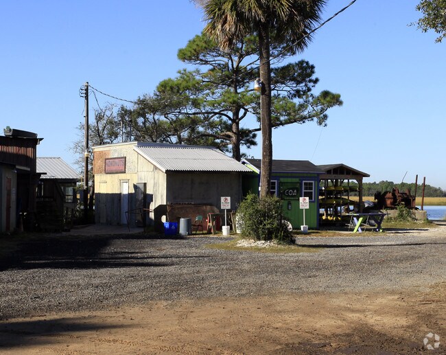
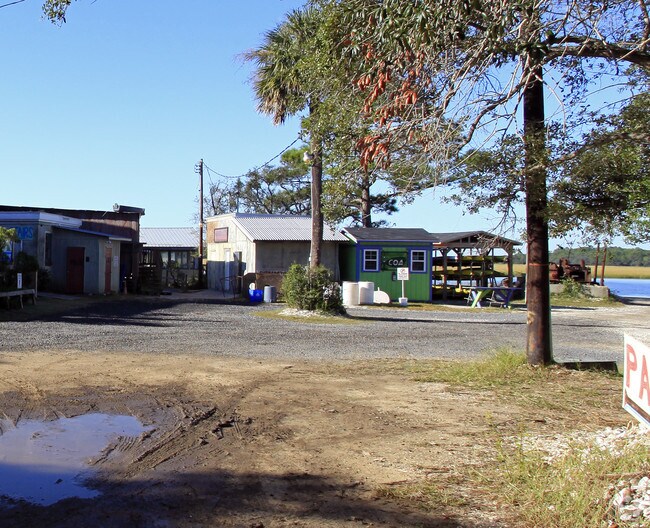
Property Detail
1870 Bowens Island Rd
Charleston-North Charleston, SC
SUBDIVISION NAME -BOWEN ISLAND DESCRIPTION -LOT 9 & ISLAND B SITE NAME -BOWEN'S ISLAND RESTRAUNT
331-00-00-003
Charleston
Commercialnec
South Carolina
AE The base floodplain where base flood elevations are provided. AE Zones are now used on new format FIRMs instead of A1-A30 Zones.
9
2025
1.70 AC
2024
James Island/Folly Beach
002008
Charleston/N Charleston
3,326 SF
NEARBY LISTINGS FOR SALE OR LEASE
-
-
View all Charleston listings for sale on LoopNet.com
DEMOGRAPHICS near 1870 Bowens Island Rd
1 mile
3 mile
5 mile
2025 Total Population
1,144
9,957
28,973
2030 Population
1,224
10,243
29,866
Pop Growth 2025-2030
+ 6.99%
+ 2.87%
+ 3.08%
Average Age
49
44
43
2025 Total Households
530
4,503
12,693
HH Growth 2025-2030
+ 7.17%
+ 2.89%
+ 3.15%
Median Household Inc
$94,047
$98,114
$102,768
Avg Household Size
2.20
2.20
2.20
2025 Avg HH Vehicles
2.00
2.00
2.00
Median Home Value
$492,940
$524,534
$478,633
Median Year Built
1997
1995
1989
Nearby Places
Map Layers
Map Styles
 Street
 Aerial
Layers
 Traffic
 Biking
Places
Listings with unknown addresses are not visible on the map
- Restaurants
- Banks
- Shops
- Fitness
- Groceries
PUBLIC TRANSPORTATION
AIRPORT
Charleston AFB/International
Drive
Walk
Distance
Charleston AFB/International
38 min
21.4 mi
Freight Ports
Columbus Street Terminal
Drive
Walk
Distance
Columbus Street Terminal
20 min
10.6 mi
Nearby Properties
Address
Land Use
TOTAL SIZE
Lot Size
Zoning
Address
Land Use
TOTAL SIZE
Lot Size
Zoning
3,780 SF
14.35 AC
Address
Land Use
TOTAL SIZE
Lot Size
Zoning
14,474 SF
23.53 AC
Address
Land Use
TOTAL SIZE
Lot Size
Zoning
Address
Land Use
TOTAL SIZE
Lot Size
Zoning
83,587 SF
2.37 AC
Address
Land Use
TOTAL SIZE
Lot Size
Zoning
7.46 AC
Address
Land Use
TOTAL SIZE
Lot Size
Zoning
39,428 SF
17.98 AC
Address
Land Use
TOTAL SIZE
Lot Size
Zoning
1,348 SF
6.87 AC
Address
Land Use
TOTAL SIZE
Lot Size
Zoning
2,459 SF
0.39 AC
Address
Land Use
TOTAL SIZE
Lot Size
Zoning
34,233 SF
9.64 AC
Address
Land Use
TOTAL SIZE
Lot Size
Zoning
11,428 SF
3.05 AC
Address
Land Use
TOTAL SIZE
Lot Size
Zoning
7,095 SF
0.24 AC
Address
Land Use
TOTAL SIZE
Lot Size
Zoning
1,182 SF
0.22 AC
Address
Land Use
TOTAL SIZE
Lot Size
Zoning
0.24 AC
Address
Land Use
TOTAL SIZE
Lot Size
Zoning
1.05 AC
Address
Land Use
TOTAL SIZE
Lot Size
Zoning
0.24 AC
Address
Land Use
TOTAL SIZE
Lot Size
Zoning
26,897 SF
3.40 AC
Address
Land Use
TOTAL SIZE
Lot Size
Zoning
4,520 SF
0.11 AC
Address
Land Use
TOTAL SIZE
Lot Size
Zoning
Address
Land Use
TOTAL SIZE
Lot Size
Zoning
1,576 SF
3.19 AC
Address
Land Use
TOTAL SIZE
Lot Size
Zoning
528 SF
2.50 AC
Address
Land Use
TOTAL SIZE
Lot Size
Zoning
20,056 SF
4.33 AC
Address
Land Use
TOTAL SIZE
Lot Size
Zoning
1.03 AC
Address
Land Use
TOTAL SIZE
Lot Size
Zoning
4,240 SF
0.22 AC
Address
Land Use
TOTAL SIZE
Lot Size
Zoning
1,196 SF
0.25 AC
Address
Land Use
TOTAL SIZE
Lot Size
Zoning
Address
Land Use
TOTAL SIZE
Lot Size
Zoning
0.82 AC
Address
Land Use
TOTAL SIZE
Lot Size
Zoning
Address
Land Use
TOTAL SIZE
Lot Size
Zoning
2,750 SF
0.34 AC
Address
Land Use
TOTAL SIZE
Lot Size
Zoning
2,574 SF
2.18 AC
Address
Land Use
TOTAL SIZE
Lot Size
Zoning
4,053 SF
1.11 AC
The World's #1 Commercial Real Estate Marketplace
Connect with us
© 2026 CoStar Group
The information above has been obtained from sources believed reliable. While we do not doubt its accuracy we have not verified it and make no guarantee, warranty or representation about it. It is your responsibility to independently confirm its accuracy and completeness. Any projections, opinions, assumptions, or estimates used are for example only and do not represent the current or future performance of the property. The value of this transaction to you depends on tax and other factors which should be evaluated by your tax, financial, and legal advisors. You and your advisors should conduct a careful, independent investigation of the property to determine to your satisfaction the suitability of the property for your needs.