Property Record
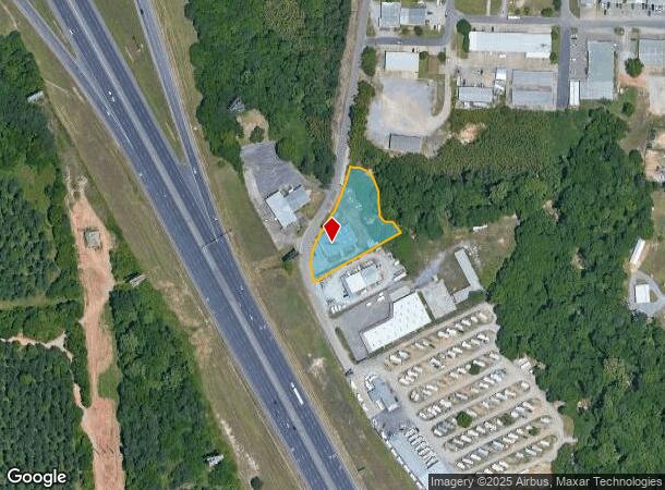
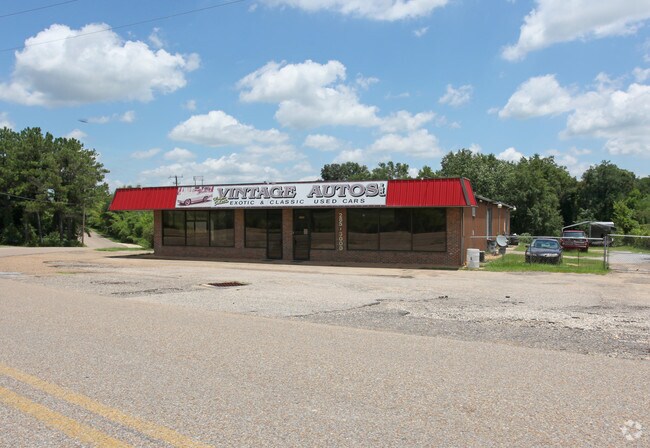
1870 I65 Service Rd E, Millbrook, AL 36054

NEARBY LISTINGS FOR SALE OR LEASE
Property Detail
1870 I65 Service Rd E
26-04-17-0-001-010000-0
1.03 ACRE SEC 17 T17 R17
Realpropertynec
Elmore
X
Alabama
01001C0360E
1.03 AC
2025
Prattville/Millbrook
2024
Montgomery
031300
Montgomery, AL
6,000 SF
DEMOGRAPHICS near 1870 I65 Service Rd E
1 Mile
3 Mile
5 Mile
2024 Total Population
655
18,780
44,772
2029 Population
662
19,412
46,121
Pop Growth 2024-2029
+ 1.07%
+ 3.37%
+ 3.01%
Average Age
39
38
39
2024 Total Households
270
7,677
17,708
HH Growth 2024-2029
+ 1.11%
+ 3.24%
+ 2.90%
Median Household Inc
$44,038
$59,467
$57,185
Avg Household Size
2.30
2.40
2.50
2024 Avg HH Vehicles
2.00
2.00
2.00
Median Home Value
$155,357
$180,353
$173,602
Median Year Built
1986
1997
1993
Nearby Places
Map Layers
Map Styles
 Street
 Aerial
- Restaurants
- Banks
- Shops
- Fitness
- Groceries
PUBLIC TRANSPORTATION
AIRPORT
Montgomery Regional (Dannelly Field)
DRIVE
WALK
Distance
Montgomery Regional (Dannelly Field)
32 min
19.1 mi
Nearby Properties
Address
Land Use
TOTAL SIZE
Lot Size
Zoning
Address
Land Use
TOTAL SIZE
Lot Size
Zoning
22,743 SF
20 AC
Address
Land Use
TOTAL SIZE
Lot Size
Zoning
22,194 SF
17.30 AC
Address
Land Use
TOTAL SIZE
Lot Size
Zoning
53,641 SF
47.75 AC
Address
Land Use
TOTAL SIZE
Lot Size
Zoning
136,080 SF
26.42 AC
Address
Land Use
TOTAL SIZE
Lot Size
Zoning
98,613 SF
10.45 AC
Address
Land Use
TOTAL SIZE
Lot Size
Zoning
9,976 SF
8.26 AC
Address
Land Use
TOTAL SIZE
Lot Size
Zoning
7,032 SF
8.52 AC
Address
Land Use
TOTAL SIZE
Lot Size
Zoning
9,176 SF
11.39 AC
Address
Land Use
TOTAL SIZE
Lot Size
Zoning
217,253 SF
29.84 AC
Address
Land Use
TOTAL SIZE
Lot Size
Zoning
18,592 SF
5 AC
Address
Land Use
TOTAL SIZE
Lot Size
Zoning
199,677 SF
22.90 AC
Address
Land Use
TOTAL SIZE
Lot Size
Zoning
128,384 SF
9.07 AC
Address
Land Use
TOTAL SIZE
Lot Size
Zoning
56,588 SF
22.74 AC
Address
Land Use
TOTAL SIZE
Lot Size
Zoning
136,297 SF
16.32 AC
Address
Land Use
TOTAL SIZE
Lot Size
Zoning
90,958 SF
8.15 AC
Address
Land Use
TOTAL SIZE
Lot Size
Zoning
75,571 SF
17.63 AC
Address
Land Use
TOTAL SIZE
Lot Size
Zoning
12,960 SF
13 AC
Address
Land Use
TOTAL SIZE
Lot Size
Zoning
31.40 AC
Address
Land Use
TOTAL SIZE
Lot Size
Zoning
90,997 SF
24.80 AC
Address
Land Use
TOTAL SIZE
Lot Size
Zoning
4,050 SF
40.59 AC
Address
Land Use
TOTAL SIZE
Lot Size
Zoning
44,892 SF
2.18 AC
Address
Land Use
TOTAL SIZE
Lot Size
Zoning
104,965 SF
10.13 AC
Address
Land Use
TOTAL SIZE
Lot Size
Zoning
57,782 SF
3.30 AC
Address
Land Use
TOTAL SIZE
Lot Size
Zoning
38,672 SF
1.66 AC
Address
Land Use
TOTAL SIZE
Lot Size
Zoning
18,384 SF
2.40 AC
Address
Land Use
TOTAL SIZE
Lot Size
Zoning
60,838 SF
Address
Land Use
TOTAL SIZE
Lot Size
Zoning
53,559 SF
3.25 AC
Address
Land Use
TOTAL SIZE
Lot Size
Zoning
3,168 SF
7.69 AC
Address
Land Use
TOTAL SIZE
Lot Size
Zoning
39,155 SF
3.61 AC
Address
Land Use
TOTAL SIZE
Lot Size
Zoning
46,325 SF
5.90 AC
The World's #1 Commercial Real Estate Marketplace
Connect with us
© 2025 CoStar Group
The information above has been obtained from sources believed reliable. While we do not doubt its accuracy we have not verified it and make no guarantee, warranty or representation about it. It is your responsibility to independently confirm its accuracy and completeness. Any projections, opinions, assumptions, or estimates used are for example only and do not represent the current or future performance of the property. The value of this transaction to you depends on tax and other factors which should be evaluated by your tax, financial, and legal advisors. You and your advisors should conduct a careful, independent investigation of the property to determine to your satisfaction the suitability of the property for your needs.