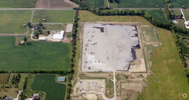
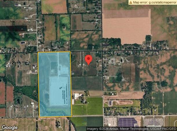
Property Record
1870 W Ginghamsburg Frederick Rd, Tipp City, OH 45371
NEARBY LISTINGS FOR SALE OR LEASE
-
-
View all Tipp City listings for sale on LoopNet.com
Property Detail
1870 W Ginghamsburg Frederick Rd
G12050700
6-4-32 W 1/2 SW
Farms
Miami
X
Ohio
39109C0265E
81.93 AC
2024
North Dayton
2024
Cincinnati/Dayton
350101
Dayton, OH
DEMOGRAPHICS near 1870 W Ginghamsburg Frederick Rd
1 Mile
3 Mile
5 Mile
2024 Total Population
399
7,927
41,247
2029 Population
407
7,994
41,449
Pop Growth 2024-2029
+ 2.01%
+ 0.85%
+ 0.49%
Average Age
45
43
43
2024 Total Households
152
3,258
17,423
HH Growth 2024-2029
+ 1.97%
+ 0.61%
+ 0.38%
Median Household Inc
$71,470
$75,994
$71,505
Avg Household Size
2.40
2.30
2.30
2024 Avg HH Vehicles
3.00
2.00
2.00
Median Home Value
$234,259
$219,753
$195,775
Median Year Built
1970
1968
1972
Nearby Places
Map Layers
Map Styles
 Street
 Aerial
- Restaurants
- Banks
- Shops
- Fitness
- Groceries
PUBLIC TRANSPORTATION
AIRPORT
James M Cox Dayton International
DRIVE
WALK
Distance
James M Cox Dayton International
14 min
6.7 mi
Freight Ports
Port of Toledo
DRIVE
WALK
Distance
Port of Toledo
169 min
142.3 mi
Nearby Properties
Address
Land Use
TOTAL SIZE
Lot Size
Zoning
Address
Land Use
TOTAL SIZE
Lot Size
Zoning
1,841,033 SF
129.70 AC
Address
Land Use
TOTAL SIZE
Lot Size
Zoning
551,408 SF
71 AC
Address
Land Use
TOTAL SIZE
Lot Size
Zoning
573,962 SF
879.20 AC
Address
Land Use
TOTAL SIZE
Lot Size
Zoning
634,247 SF
86.18 AC
Address
Land Use
TOTAL SIZE
Lot Size
Zoning
834,238 SF
42.05 AC
Address
Land Use
TOTAL SIZE
Lot Size
Zoning
704,988 SF
49.15 AC
Address
Land Use
TOTAL SIZE
Lot Size
Zoning
664,824 SF
1,128.84 AC
Address
Land Use
TOTAL SIZE
Lot Size
Zoning
54,635 SF
17.25 AC
Address
Land Use
TOTAL SIZE
Lot Size
Zoning
1,841,033 SF
129.70 AC
Address
Land Use
TOTAL SIZE
Lot Size
Zoning
371,869 SF
160.30 AC
Address
Land Use
TOTAL SIZE
Lot Size
Zoning
527,904 SF
75.35 AC
Address
Land Use
TOTAL SIZE
Lot Size
Zoning
597,314 SF
38.27 AC
Address
Land Use
TOTAL SIZE
Lot Size
Zoning
522,340 SF
36.59 AC
Address
Land Use
TOTAL SIZE
Lot Size
Zoning
425,641 SF
33.79 AC
Address
Land Use
TOTAL SIZE
Lot Size
Zoning
143,980 SF
35.40 AC
Address
Land Use
TOTAL SIZE
Lot Size
Zoning
222,799 SF
13.74 AC
Address
Land Use
TOTAL SIZE
Lot Size
Zoning
21,473 SF
8.37 AC
Address
Land Use
TOTAL SIZE
Lot Size
Zoning
179,704 SF
18.68 AC
Address
Land Use
TOTAL SIZE
Lot Size
Zoning
Address
Land Use
TOTAL SIZE
Lot Size
Zoning
184,413 SF
9.39 AC
Address
Land Use
TOTAL SIZE
Lot Size
Zoning
122,400 SF
20.34 AC
Address
Land Use
TOTAL SIZE
Lot Size
Zoning
41,084 SF
13.28 AC
Address
Land Use
TOTAL SIZE
Lot Size
Zoning
120,000 SF
12.02 AC
Address
Land Use
TOTAL SIZE
Lot Size
Zoning
46,800 SF
3.06 AC
Address
Land Use
TOTAL SIZE
Lot Size
Zoning
2,300 SF
8.50 AC
Address
Land Use
TOTAL SIZE
Lot Size
Zoning
61,273 SF
6.39 AC
Address
Land Use
TOTAL SIZE
Lot Size
Zoning
25,780 SF
9.35 AC
Address
Land Use
TOTAL SIZE
Lot Size
Zoning
24,600 SF
6.97 AC
Address
Land Use
TOTAL SIZE
Lot Size
Zoning
664,824 SF
39.27 AC
Address
Land Use
TOTAL SIZE
Lot Size
Zoning
12,832 SF
14.37 AC
The World's #1 Commercial Real Estate Marketplace
Connect with us
© 2025 CoStar Group
The information above has been obtained from sources believed reliable. While we do not doubt its accuracy we have not verified it and make no guarantee, warranty or representation about it. It is your responsibility to independently confirm its accuracy and completeness. Any projections, opinions, assumptions, or estimates used are for example only and do not represent the current or future performance of the property. The value of this transaction to you depends on tax and other factors which should be evaluated by your tax, financial, and legal advisors. You and your advisors should conduct a careful, independent investigation of the property to determine to your satisfaction the suitability of the property for your needs.