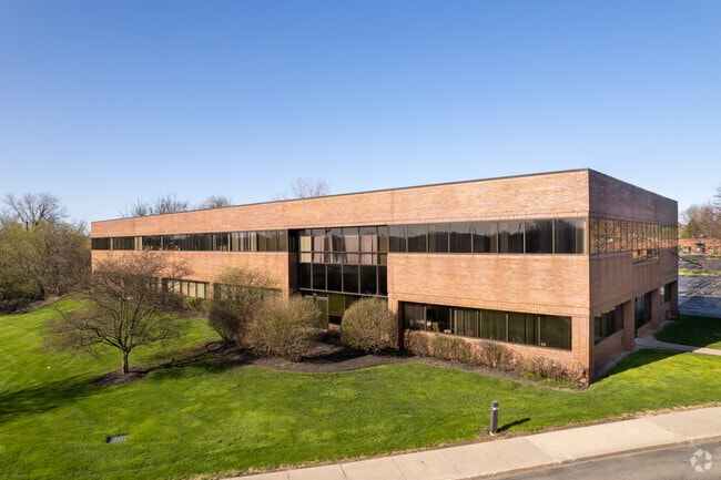
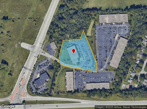
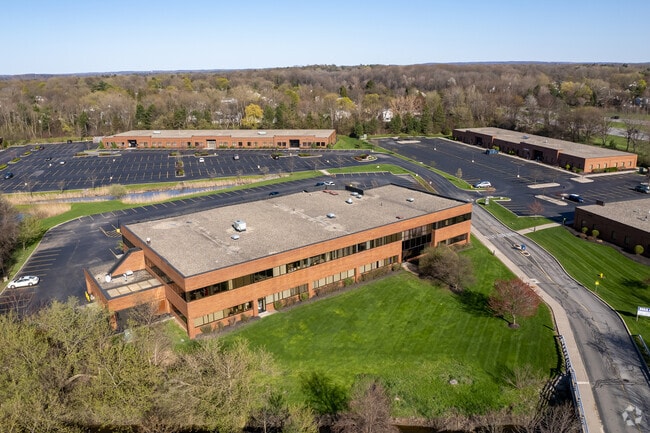
Property Record
1870 Winton Rd S, Rochester, NY 14618
Current Lease Availabilities
NEARBY LISTINGS FOR SALE OR LEASE
Property Detail
1870 Winton Rd S
Rochester, NY
Cambridge Place Corporate Centre Subdivi
262000-150-050-0001-043-400
LOT #4 CAMBRIDGE PLACE
Professionalbldglegalinsurancerealestateetc
Monroe
AE
New York
36055C0352G
43.400
2025
3.06 AC
2024
South Central
013003
Rochester
37,439 SF
DEMOGRAPHICS near 1870 Winton Rd S
1 Mile
3 Mile
5 Mile
2024 Total Population
9,396
80,369
230,397
2029 Population
9,318
79,158
227,067
Pop Growth 2024-2029
(0.83%)
(1.51%)
(1.45%)
Average Age
43
41
39
2024 Total Households
3,999
37,244
102,487
HH Growth 2024-2029
(0.80%)
(1.67%)
(1.49%)
Median Household Inc
$93,946
$67,677
$58,965
Avg Household Size
2.20
2.00
2.10
2024 Avg HH Vehicles
2.00
1.00
1.00
Median Home Value
$229,629
$237,578
$179,385
Median Year Built
1968
1955
1952
Nearby Places
- Restaurants
- Banks
- Shops
- Fitness
- Groceries
PUBLIC TRANSPORTATION
COMMUTER RAIL
Rochester (Empire Service - VIA Rail, Lake Shore Limited - VIA Rail, Maple Leaf - VIA Rail, Toronto - New York - VIA Rail)
DRIVE
WALK
Distance
Rochester (Empire Service - VIA Rail, Lake Shore Limited - VIA Rail, Maple Leaf - VIA Rail, Toronto - New York - VIA Rail)
11 min
5.2 mi
AIRPORT
Frederick Douglass/Greater Rochester International
DRIVE
WALK
Distance
Frederick Douglass/Greater Rochester International
10 min
5.9 mi
Freight Ports
Albany, NY Port
DRIVE
WALK
Distance
Albany, NY Port
264 min
223.1 mi
Nearby Properties
Address
Land Use
TOTAL SIZE
Lot Size
Zoning
Address
Land Use
TOTAL SIZE
Lot Size
Zoning
57,638 SF
227.96 AC
02 - SINGL
Address
Land Use
TOTAL SIZE
Lot Size
Zoning
1,216,095 SF
22.89 AC
Address
Land Use
TOTAL SIZE
Lot Size
Zoning
Address
Land Use
TOTAL SIZE
Lot Size
Zoning
400,000 SF
43.50 AC
06 - INDUS
Address
Land Use
TOTAL SIZE
Lot Size
Zoning
65,745 SF
154.98 AC
Address
Land Use
TOTAL SIZE
Lot Size
Zoning
60,120 SF
12.90 AC
Address
Land Use
TOTAL SIZE
Lot Size
Zoning
7.15 AC
Address
Land Use
TOTAL SIZE
Lot Size
Zoning
7,800 SF
166.42 AC
02 - SINGL
Address
Land Use
TOTAL SIZE
Lot Size
Zoning
1,878,160 SF
4.05 AC
Address
Land Use
TOTAL SIZE
Lot Size
Zoning
51,276 SF
48.95 AC
02 - SINGL
Address
Land Use
TOTAL SIZE
Lot Size
Zoning
01 - NOT Z
Address
Land Use
TOTAL SIZE
Lot Size
Zoning
Address
Land Use
TOTAL SIZE
Lot Size
Zoning
614,053 SF
9.30 AC
Address
Land Use
TOTAL SIZE
Lot Size
Zoning
01 - NOT Z
Address
Land Use
TOTAL SIZE
Lot Size
Zoning
330,090 SF
62.41 AC
Address
Land Use
TOTAL SIZE
Lot Size
Zoning
01 - NOT Z
Address
Land Use
TOTAL SIZE
Lot Size
Zoning
0.01 AC
Address
Land Use
TOTAL SIZE
Lot Size
Zoning
6,056 SF
37.65 AC
Address
Land Use
TOTAL SIZE
Lot Size
Zoning
01 - NOT Z
Address
Land Use
TOTAL SIZE
Lot Size
Zoning
128,539 SF
15.01 AC
Address
Land Use
TOTAL SIZE
Lot Size
Zoning
424,207 SF
39.50 AC
Address
Land Use
TOTAL SIZE
Lot Size
Zoning
Address
Land Use
TOTAL SIZE
Lot Size
Zoning
130,830 SF
19.20 AC
Address
Land Use
TOTAL SIZE
Lot Size
Zoning
01 - NOT Z
Address
Land Use
TOTAL SIZE
Lot Size
Zoning
Address
Land Use
TOTAL SIZE
Lot Size
Zoning
01 - NOT Z
Address
Land Use
TOTAL SIZE
Lot Size
Zoning
Address
Land Use
TOTAL SIZE
Lot Size
Zoning
209,996 SF
36.56 AC
Address
Land Use
TOTAL SIZE
Lot Size
Zoning
160,758 SF
20.95 AC
02 - SINGL
Address
Land Use
TOTAL SIZE
Lot Size
Zoning
241,650 SF
23.77 AC
The World's #1 Commercial Real Estate Marketplace
Connect with us
© 2025 CoStar Group
The information above has been obtained from sources believed reliable. While we do not doubt its accuracy we have not verified it and make no guarantee, warranty or representation about it. It is your responsibility to independently confirm its accuracy and completeness. Any projections, opinions, assumptions, or estimates used are for example only and do not represent the current or future performance of the property. The value of this transaction to you depends on tax and other factors which should be evaluated by your tax, financial, and legal advisors. You and your advisors should conduct a careful, independent investigation of the property to determine to your satisfaction the suitability of the property for your needs.