Property Record
18715 120Th Ave Ne, Bothell, WA 98011
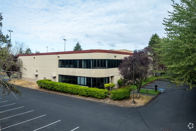


Property Detail
18715 120Th Ave Ne
Seattle-Tacoma-Bellevue, WA
QUADRANT BUSINESS PARK - BOTHELL LOT 26 LESS POR DAF - BEG AT MOST ELY COR OF LOT 26 TH N 37-18-18 W ALG W MGN OF 120TH AVE NE 11.09 FT TH S 68-20-36 W 331.68 FT TO SLY COR OF SD LOT TH N 70-10-15 E ALG SLY LN OF SD LOT 334.84 FT TO POB - AKA LOT A O
697920-0260
King
Datacentre
Washington
R-AC, OP,
26
2025
2 AC
2024
Bothell/Kenmore
021802
Seattle/Puget Sound
30,705 SF
NEARBY LISTINGS FOR SALE OR LEASE
DEMOGRAPHICS near 18715 120Th Ave Ne
1 mile
3 mile
5 mile
2025 Total Population
11,053
90,336
238,211
2030 Population
11,512
94,269
247,844
Pop Growth 2025-2030
+ 4.15%
+ 4.35%
+ 4.04%
Average Age
38
40
39
2025 Total Households
4,420
34,904
90,235
HH Growth 2025-2030
+ 4.23%
+ 4.47%
+ 4.20%
Median Household Inc
$137,531
$148,905
$149,684
Avg Household Size
2.40
2.50
2.60
2025 Avg HH Vehicles
2.00
2.00
2.00
Median Home Value
$950,057
$997,572
$944,946
Median Year Built
1993
1991
1988
Nearby Places
Map Layers
Map Styles
 Street
 Aerial
Layers
 Traffic
 Biking
Places
Listings with unknown addresses are not visible on the map
- Restaurants
- Banks
- Shops
- Fitness
- Groceries
PUBLIC TRANSPORTATION
AIRPORT
Seattle Paine Field International
Drive
Walk
Distance
Seattle Paine Field International
25 min
15.1 mi
Seattle-Tacoma International
Drive
Walk
Distance
Seattle-Tacoma International
41 min
29.0 mi
Nearby Properties
Address
Land Use
TOTAL SIZE
Lot Size
Zoning
Address
Land Use
TOTAL SIZE
Lot Size
Zoning
50,400 SF
123.66 AC
C
Address
Land Use
TOTAL SIZE
Lot Size
Zoning
11.29 AC
R-AC, OP,
Address
Land Use
TOTAL SIZE
Lot Size
Zoning
2.60 AC
DN
Address
Land Use
TOTAL SIZE
Lot Size
Zoning
343,095 SF
39.09 AC
R 5,400A,
Address
Land Use
TOTAL SIZE
Lot Size
Zoning
295,920 SF
17.30 AC
R-18
Address
Land Use
TOTAL SIZE
Lot Size
Zoning
293,664 SF
38.51 AC
R 2800, OP
Address
Land Use
TOTAL SIZE
Lot Size
Zoning
270,101 SF
78.77 AC
LI
Address
Land Use
TOTAL SIZE
Lot Size
Zoning
190,512 SF
4.86 AC
CBD
Address
Land Use
TOTAL SIZE
Lot Size
Zoning
194,388 SF
1.65 AC
DC
Address
Land Use
TOTAL SIZE
Lot Size
Zoning
264,253 SF
29.11 AC
R 4,000
Address
Land Use
TOTAL SIZE
Lot Size
Zoning
226,192 SF
6.35 AC
CBD
Address
Land Use
TOTAL SIZE
Lot Size
Zoning
394,152 SF
18 AC
E-M
Address
Land Use
TOTAL SIZE
Lot Size
Zoning
170,520 SF
1.92 AC
DN
Address
Land Use
TOTAL SIZE
Lot Size
Zoning
217,877 SF
17.03 AC
R 2,800
Address
Land Use
TOTAL SIZE
Lot Size
Zoning
181,008 SF
9.76 AC
E-L
Address
Land Use
TOTAL SIZE
Lot Size
Zoning
75,661 SF
30.54 AC
R 8400
Address
Land Use
TOTAL SIZE
Lot Size
Zoning
187,590 SF
17.20 AC
R 2800, OP
Address
Land Use
TOTAL SIZE
Lot Size
Zoning
47,176 SF
38.88 AC
R 9,600
Address
Land Use
TOTAL SIZE
Lot Size
Zoning
122,766 SF
2 AC
GDC
Address
Land Use
TOTAL SIZE
Lot Size
Zoning
130,800 SF
2.28 AC
CBD
Address
Land Use
TOTAL SIZE
Lot Size
Zoning
182,875 SF
16.47 AC
R-AC, OP,
Address
Land Use
TOTAL SIZE
Lot Size
Zoning
204,428 SF
34.65 AC
R 9600
Address
Land Use
TOTAL SIZE
Lot Size
Zoning
119,470 SF
1.56 AC
DN
Address
Land Use
TOTAL SIZE
Lot Size
Zoning
126,522 SF
2.62 AC
CBD
Address
Land Use
TOTAL SIZE
Lot Size
Zoning
114,513 SF
2.35 AC
GDC
Address
Land Use
TOTAL SIZE
Lot Size
Zoning
113,880 SF
1.56 AC
GDC
Address
Land Use
TOTAL SIZE
Lot Size
Zoning
229,632 SF
37.61 AC
P/I
Address
Land Use
TOTAL SIZE
Lot Size
Zoning
173,130 SF
10.27 AC
E-L
Address
Land Use
TOTAL SIZE
Lot Size
Zoning
177,300 SF
15.50 AC
OR-M
Address
Land Use
TOTAL SIZE
Lot Size
Zoning
222,333 SF
36.10 AC
E-M
The World's #1 Commercial Real Estate Marketplace
Connect with us
© 2026 CoStar Group
The information above has been obtained from sources believed reliable. While we do not doubt its accuracy we have not verified it and make no guarantee, warranty or representation about it. It is your responsibility to independently confirm its accuracy and completeness. Any projections, opinions, assumptions, or estimates used are for example only and do not represent the current or future performance of the property. The value of this transaction to you depends on tax and other factors which should be evaluated by your tax, financial, and legal advisors. You and your advisors should conduct a careful, independent investigation of the property to determine to your satisfaction the suitability of the property for your needs.