Property Record
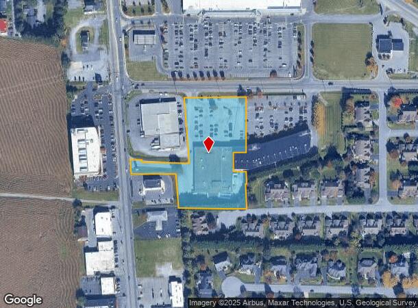
18717 N North Pointe Dr, Hagerstown, MD 21742

NEARBY LISTINGS FOR SALE OR LEASE
Property Detail
18717 N North Pointe Dr
Hagerstown-Martinsburg, MD-WV
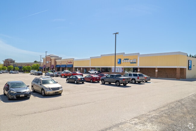
Food Lion
27-029507
LOT 1 3.37 ACRES 18717 NORTH POINTE DRIVE CNR LONGMEADOW RD & RT11
Supermarket
Washington
X
Maryland
24043C0137D
1
2024
3.36 AC
2025
Washington County
010300
Washington, DC
32,640 SF
DEMOGRAPHICS near 18717 N North Pointe Dr
1 Mile
3 Mile
5 Mile
2024 Total Population
4,527
46,419
82,131
2029 Population
4,546
47,038
83,129
Pop Growth 2024-2029
+ 0.42%
+ 1.33%
+ 1.22%
Average Age
41
39
40
2024 Total Households
1,724
18,421
32,789
HH Growth 2024-2029
+ 0.52%
+ 1.42%
+ 1.25%
Median Household Inc
$83,469
$55,091
$54,862
Avg Household Size
2.60
2.40
2.40
2024 Avg HH Vehicles
2.00
2.00
2.00
Median Home Value
$309,066
$211,815
$211,945
Median Year Built
1974
1967
1969
Nearby Places
Map Layers
Map Styles
 Street
 Aerial
- Restaurants
- Banks
- Shops
- Fitness
- Groceries
PUBLIC TRANSPORTATION
AIRPORT
Hagerstown Regional/Richard A Henson Field
DRIVE
WALK
Distance
Hagerstown Regional/Richard A Henson Field
5 min
2.0 mi
Freight Ports
Port of Baltimore
DRIVE
WALK
Distance
Port of Baltimore
97 min
79.8 mi
SALE & LEASE HISTORY
LISTING DATE
SALE/LEASE

Sep 10, 2019
For Lease
Sep 09, 2019
For Lease
May 15, 2019
For Lease
Jul 24, 2018
For Sale
Nearby Properties
Address
Land Use
TOTAL SIZE
Lot Size
Zoning
Address
Land Use
TOTAL SIZE
Lot Size
Zoning
1,190,700 SF
83.26 AC
HI
Address
Land Use
TOTAL SIZE
Lot Size
Zoning
23,941 SF
401.89 AC
U
Address
Land Use
TOTAL SIZE
Lot Size
Zoning
801,000 SF
86.86 AC
HI
Address
Land Use
TOTAL SIZE
Lot Size
Zoning
36,685 SF
281.72 AC
IG
Address
Land Use
TOTAL SIZE
Lot Size
Zoning
216 SF
52.93 AC
RH
Address
Land Use
TOTAL SIZE
Lot Size
Zoning
12,580 SF
1.73 AC
CCMU
Address
Land Use
TOTAL SIZE
Lot Size
Zoning
151,660 SF
56.24 AC
RMOD
Address
Land Use
TOTAL SIZE
Lot Size
Zoning
117,096 SF
28.13 AC
CR
Address
Land Use
TOTAL SIZE
Lot Size
Zoning
267,424 SF
21.44 AC
IMU
Address
Land Use
TOTAL SIZE
Lot Size
Zoning
82,403 SF
1.32 AC
CCMU
Address
Land Use
TOTAL SIZE
Lot Size
Zoning
127,315 SF
26.65 AC
RMOD
Address
Land Use
TOTAL SIZE
Lot Size
Zoning
76,740 SF
16.01 AC
CG
Address
Land Use
TOTAL SIZE
Lot Size
Zoning
6,778 SF
8.24 AC
RH
Address
Land Use
TOTAL SIZE
Lot Size
Zoning
91,586 SF
28.49 AC
U
Address
Land Use
TOTAL SIZE
Lot Size
Zoning
65,433 SF
16.52 AC
PUD
Address
Land Use
TOTAL SIZE
Lot Size
Zoning
5,090 SF
25.27 AC
RMOD
Address
Land Use
TOTAL SIZE
Lot Size
Zoning
3,984 SF
18.32 AC
CR
Address
Land Use
TOTAL SIZE
Lot Size
Zoning
71,928 SF
24.77 AC
RMOD
Address
Land Use
TOTAL SIZE
Lot Size
Zoning
123,120 SF
28.54 AC
ORT
Address
Land Use
TOTAL SIZE
Lot Size
Zoning
17,574 SF
13.98 AC
RH
Address
Land Use
TOTAL SIZE
Lot Size
Zoning
23,086 SF
19.36 AC
CR
Address
Land Use
TOTAL SIZE
Lot Size
Zoning
150,000 SF
22.73 AC
HI
Address
Land Use
TOTAL SIZE
Lot Size
Zoning
3,159 SF
14.99 AC
CR
Address
Land Use
TOTAL SIZE
Lot Size
Zoning
764,619 SF
31.10 AC
IG
Address
Land Use
TOTAL SIZE
Lot Size
Zoning
21,306 SF
4.64 AC
IMU
Address
Land Use
TOTAL SIZE
Lot Size
Zoning
35,402 SF
10.18 AC
BG
Address
Land Use
TOTAL SIZE
Lot Size
Zoning
18,799 SF
0.75 AC
CCMU
Address
Land Use
TOTAL SIZE
Lot Size
Zoning
79,084 SF
12.50 AC
RMOD
Address
Land Use
TOTAL SIZE
Lot Size
Zoning
84,796 SF
8.81 AC
PB
Address
Land Use
TOTAL SIZE
Lot Size
Zoning
78,042 SF
11 AC
RB-E
The World's #1 Commercial Real Estate Marketplace
Connect with us
© 2025 CoStar Group
The information above has been obtained from sources believed reliable. While we do not doubt its accuracy we have not verified it and make no guarantee, warranty or representation about it. It is your responsibility to independently confirm its accuracy and completeness. Any projections, opinions, assumptions, or estimates used are for example only and do not represent the current or future performance of the property. The value of this transaction to you depends on tax and other factors which should be evaluated by your tax, financial, and legal advisors. You and your advisors should conduct a careful, independent investigation of the property to determine to your satisfaction the suitability of the property for your needs.