Property Record
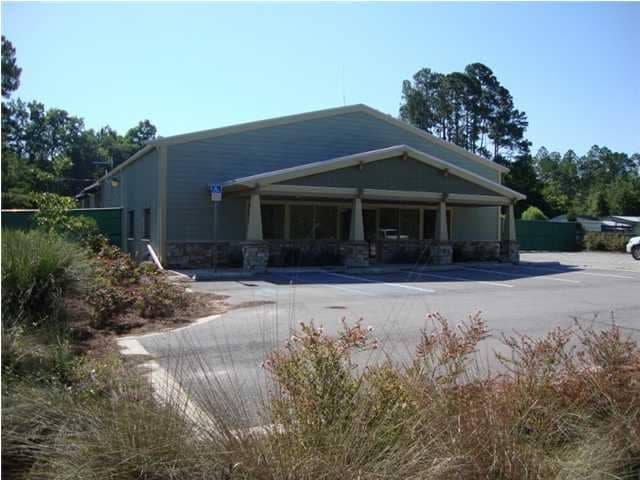
18725 Us Highway 331 S, Freeport, FL 32439


NEARBY LISTINGS FOR SALE OR LEASE
-
-
View all Freeport listings for sale on LoopNet.com
Property Detail
18725 Us Highway 331 S
34-1S-19-23000-003-0000
Mallet Pines S/D Unrecd
Privateschool
COM @ NE/C; W 1760FT TO E ROW OF US HWY #331; S ALONG ROW 1174.81FT TO POB; E 420FT, N 210FT, W 420FT, S 210FT TO POB *LESS S 67.99FT OF W 210FT OR 2486-1317 OR 2773-2076 OR 2844-4936 OR 2924-280
AE
Walton
12131C0559H
Florida
2025
1.68 AC
2025
Florida Panhandle Area
950501
Other Market Areas
5,792 SF
Crestview-Fort Walton Beach-Destin, FL
DEMOGRAPHICS near 18725 Us Highway 331 S
1 Mile
3 Mile
5 Mile
2024 Total Population
532
4,597
9,827
2029 Population
654
5,652
12,193
Pop Growth 2024-2029
+ 22.93%
+ 22.95%
+ 24.08%
Average Age
38
39
38
2024 Total Households
194
1,697
3,616
HH Growth 2024-2029
+ 23.71%
+ 23.16%
+ 24.39%
Median Household Inc
$61,562
$53,414
$49,865
Avg Household Size
2.60
2.60
2.60
2024 Avg HH Vehicles
2.00
2.00
2.00
Median Home Value
$303,704
$292,263
$284,986
Median Year Built
2000
2003
2007
Nearby Places
Map Layers
Map Styles
 Street
 Aerial
- Restaurants
- Banks
- Shops
- Fitness
- Groceries
PUBLIC TRANSPORTATION
AIRPORT
Eglin AFB/Destin-Ft Walton Beach
DRIVE
WALK
Distance
Eglin AFB/Destin-Ft Walton Beach
66 min
32.4 mi
Northwest Florida Beaches International
DRIVE
WALK
Distance
Northwest Florida Beaches International
46 min
33.1 mi
Nearby Properties
Address
Land Use
TOTAL SIZE
Lot Size
Zoning
Address
Land Use
TOTAL SIZE
Lot Size
Zoning
176,047 SF
29.75 AC
Address
Land Use
TOTAL SIZE
Lot Size
Zoning
469,205 SF
21.39 AC
BYLAGR
Address
Land Use
TOTAL SIZE
Lot Size
Zoning
334,804 SF
13.94 AC
MUNI
Address
Land Use
TOTAL SIZE
Lot Size
Zoning
311,974 SF
7.28 AC
Address
Land Use
TOTAL SIZE
Lot Size
Zoning
63,166 SF
9.06 AC
3310
Address
Land Use
TOTAL SIZE
Lot Size
Zoning
88.24 AC
3310
Address
Land Use
TOTAL SIZE
Lot Size
Zoning
81,765 SF
5.51 AC
BYLAGR
Address
Land Use
TOTAL SIZE
Lot Size
Zoning
46,904 SF
93.38 AC
BYLAGR
Address
Land Use
TOTAL SIZE
Lot Size
Zoning
2,072 SF
23.08 AC
MUNI
Address
Land Use
TOTAL SIZE
Lot Size
Zoning
5,624 SF
1.35 AC
3310
Address
Land Use
TOTAL SIZE
Lot Size
Zoning
12,472 SF
10.63 AC
Address
Land Use
TOTAL SIZE
Lot Size
Zoning
51,885 SF
8.65 AC
3310
Address
Land Use
TOTAL SIZE
Lot Size
Zoning
16,297 SF
13.93 AC
Address
Land Use
TOTAL SIZE
Lot Size
Zoning
4,400 SF
6.04 AC
3310
Address
Land Use
TOTAL SIZE
Lot Size
Zoning
16,804 SF
2.07 AC
Address
Land Use
TOTAL SIZE
Lot Size
Zoning
12,290 SF
1.45 AC
Address
Land Use
TOTAL SIZE
Lot Size
Zoning
10.84 AC
MUNI
Address
Land Use
TOTAL SIZE
Lot Size
Zoning
12,080 SF
3.50 AC
3310
Address
Land Use
TOTAL SIZE
Lot Size
Zoning
924 SF
11.89 AC
3310
Address
Land Use
TOTAL SIZE
Lot Size
Zoning
17,730 SF
2.68 AC
Address
Land Use
TOTAL SIZE
Lot Size
Zoning
9,475 SF
8.45 AC
3310
Address
Land Use
TOTAL SIZE
Lot Size
Zoning
5,040 SF
36.94 AC
Address
Land Use
TOTAL SIZE
Lot Size
Zoning
38,148 SF
4.04 AC
3310
Address
Land Use
TOTAL SIZE
Lot Size
Zoning
59,516 SF
4.84 AC
MUNI
Address
Land Use
TOTAL SIZE
Lot Size
Zoning
25,532 SF
4.24 AC
Address
Land Use
TOTAL SIZE
Lot Size
Zoning
1,240 SF
99.84 AC
BYLAGR
Address
Land Use
TOTAL SIZE
Lot Size
Zoning
9,750 SF
7.60 AC
BAYN
Address
Land Use
TOTAL SIZE
Lot Size
Zoning
2.14 AC
BAYN
Address
Land Use
TOTAL SIZE
Lot Size
Zoning
2,344 SF
3.34 AC
3310
Address
Land Use
TOTAL SIZE
Lot Size
Zoning
24.46 AC
The World's #1 Commercial Real Estate Marketplace
Connect with us
© 2025 CoStar Group
The information above has been obtained from sources believed reliable. While we do not doubt its accuracy we have not verified it and make no guarantee, warranty or representation about it. It is your responsibility to independently confirm its accuracy and completeness. Any projections, opinions, assumptions, or estimates used are for example only and do not represent the current or future performance of the property. The value of this transaction to you depends on tax and other factors which should be evaluated by your tax, financial, and legal advisors. You and your advisors should conduct a careful, independent investigation of the property to determine to your satisfaction the suitability of the property for your needs.