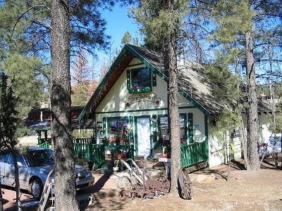
Property Record
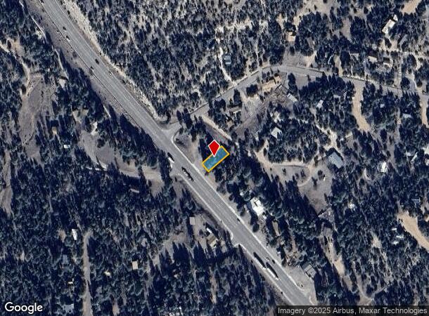
1874 State Route 260, Overgaard, AZ 85933
NEARBY LISTINGS FOR SALE OR LEASE
-
-
View all Overgaard listings for sale on LoopNet.com
Property Detail
1874 State Route 260
Show Low, AZ
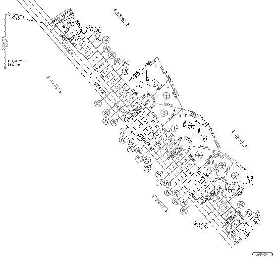
Timberlakes Pines #3
206-06-014
TIMBERLAKES PINES #3 LOT C2 LESS HWY R/W
Storebuilding
Navajo
X
Arizona
04017C4162F
c2
2024
0.14 AC
2026
Arizona Northeast & Holbrook Area
964201
Other Market Areas
779 SF
DEMOGRAPHICS near 1874 State Route 260
1 Mile
3 Mile
5 Mile
2024 Total Population
1,475
4,829
5,827
2029 Population
1,592
5,254
6,344
Pop Growth 2024-2029
+ 7.93%
+ 8.80%
+ 8.87%
Average Age
50
53
53
2024 Total Households
648
2,208
2,675
HH Growth 2024-2029
+ 7.87%
+ 8.70%
+ 8.75%
Median Household Inc
$51,031
$42,752
$42,321
Avg Household Size
2.10
2.10
2.10
2024 Avg HH Vehicles
2.00
2.00
2.00
Median Home Value
$317,605
$270,329
$267,269
Median Year Built
1996
1995
1995
Nearby Places
Map Layers
Map Styles
 Street
 Aerial
- Restaurants
- Banks
- Shops
- Fitness
- Groceries
Nearby Properties
Address
Land Use
TOTAL SIZE
Lot Size
Zoning
Address
Land Use
TOTAL SIZE
Lot Size
Zoning
18,803 SF
2.63 AC
SD
Address
Land Use
TOTAL SIZE
Lot Size
Zoning
38,053 SF
4.50 AC
R1-10
Address
Land Use
TOTAL SIZE
Lot Size
Zoning
1,143 SF
61.42 AC
A-GENERAL
Address
Land Use
TOTAL SIZE
Lot Size
Zoning
31,885 SF
2.13 AC
C-R
Address
Land Use
TOTAL SIZE
Lot Size
Zoning
29,610 SF
3.62 AC
R1-10
Address
Land Use
TOTAL SIZE
Lot Size
Zoning
11,281 SF
1.99 AC
C-R
Address
Land Use
TOTAL SIZE
Lot Size
Zoning
4,486 SF
3.68 AC
R1-10
Address
Land Use
TOTAL SIZE
Lot Size
Zoning
6,391 SF
1.04 AC
RU-1
Address
Land Use
TOTAL SIZE
Lot Size
Zoning
9,180 SF
1 AC
C-R
Address
Land Use
TOTAL SIZE
Lot Size
Zoning
2,556 SF
6.81 AC
C-R
Address
Land Use
TOTAL SIZE
Lot Size
Zoning
4,083 SF
1.31 AC
C-R
Address
Land Use
TOTAL SIZE
Lot Size
Zoning
4,393 SF
1.50 AC
R1-10
Address
Land Use
TOTAL SIZE
Lot Size
Zoning
3,416 SF
1.71 AC
A-GENERAL
Address
Land Use
TOTAL SIZE
Lot Size
Zoning
8,400 SF
0.95 AC
C-R
Address
Land Use
TOTAL SIZE
Lot Size
Zoning
3,154 SF
1.26 AC
R1-43
Address
Land Use
TOTAL SIZE
Lot Size
Zoning
3,360 SF
0.56 AC
SD
Address
Land Use
TOTAL SIZE
Lot Size
Zoning
2,726 SF
1 AC
C-R
Address
Land Use
TOTAL SIZE
Lot Size
Zoning
2,477 SF
0.41 AC
R1-10
Address
Land Use
TOTAL SIZE
Lot Size
Zoning
2,330 SF
0.70 AC
SD
Address
Land Use
TOTAL SIZE
Lot Size
Zoning
2,028 SF
2.01 AC
R1-43
Address
Land Use
TOTAL SIZE
Lot Size
Zoning
3,214 SF
1 AC
R1-10
Address
Land Use
TOTAL SIZE
Lot Size
Zoning
3,238 SF
9.50 AC
C-R
Address
Land Use
TOTAL SIZE
Lot Size
Zoning
4,847 SF
1.02 AC
C-R
Address
Land Use
TOTAL SIZE
Lot Size
Zoning
3,738 SF
0.50 AC
R1-10
Address
Land Use
TOTAL SIZE
Lot Size
Zoning
2,648 SF
1 AC
R1-43
Address
Land Use
TOTAL SIZE
Lot Size
Zoning
2,096 SF
1.12 AC
R1-10
Address
Land Use
TOTAL SIZE
Lot Size
Zoning
41.54 AC
R1-10
Address
Land Use
TOTAL SIZE
Lot Size
Zoning
3,944 SF
0.55 AC
Address
Land Use
TOTAL SIZE
Lot Size
Zoning
1,984 SF
1.10 AC
R1-43
Address
Land Use
TOTAL SIZE
Lot Size
Zoning
4,000 SF
4.30 AC
R1-10
The World's #1 Commercial Real Estate Marketplace
Connect with us
© 2026 CoStar Group
The information above has been obtained from sources believed reliable. While we do not doubt its accuracy we have not verified it and make no guarantee, warranty or representation about it. It is your responsibility to independently confirm its accuracy and completeness. Any projections, opinions, assumptions, or estimates used are for example only and do not represent the current or future performance of the property. The value of this transaction to you depends on tax and other factors which should be evaluated by your tax, financial, and legal advisors. You and your advisors should conduct a careful, independent investigation of the property to determine to your satisfaction the suitability of the property for your needs.