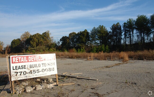
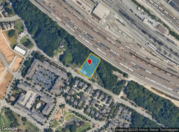
Property Record
Perry Blvd Nw, Atlanta, GA 30318

NEARBY LISTINGS FOR SALE OR LEASE
Property Detail
Perry Blvd Nw
17-0227-LL-024-2
KA VACANT LAND W/PAVING PARCEL REVIEW ** CB26 VERIFY LOT USE RMV NEG LAND INFL
Commercialnec
Fulton
X
Georgia
13121C0237F
0.75 AC
2024
West Atlanta
2025
Atlanta
008702
Atlanta-Sandy Springs-Roswell, GA
DEMOGRAPHICS near Perry Blvd Nw
1 Mile
3 Mile
5 Mile
2024 Total Population
5,322
91,136
302,496
2029 Population
5,639
95,633
314,827
Pop Growth 2024-2029
+ 5.96%
+ 4.93%
+ 4.08%
Average Age
34
36
37
2024 Total Households
2,196
40,314
139,250
HH Growth 2024-2029
+ 6.24%
+ 5.04%
+ 4.33%
Median Household Inc
$64,328
$66,478
$78,533
Avg Household Size
2.30
2.10
1.90
2024 Avg HH Vehicles
1.00
1.00
1.00
Median Home Value
$400,825
$349,184
$408,722
Median Year Built
2002
1994
1993
Nearby Places
Map Layers
Map Styles
 Street
 Aerial
- Restaurants
- Banks
- Shops
- Fitness
- Groceries
PUBLIC TRANSPORTATION
COMMUTER RAIL
DRIVE
WALK
Distance
13 min
4.8 mi
AIRPORT
Hartsfield - Jackson Atlanta International
DRIVE
WALK
Distance
Hartsfield - Jackson Atlanta International
27 min
15.0 mi
SALE & LEASE HISTORY
LISTING DATE
SALE/LEASE

Sep 24, 2016
For Sale
Nov 09, 2016
For Sale
Nearby Properties
Address
Land Use
TOTAL SIZE
Lot Size
Zoning
Address
Land Use
TOTAL SIZE
Lot Size
Zoning
519,160 SF
3.92 AC
I2
Address
Land Use
TOTAL SIZE
Lot Size
Zoning
638,721 SF
3.31 AC
I1
Address
Land Use
TOTAL SIZE
Lot Size
Zoning
961,817 SF
25.44 AC
I2
Address
Land Use
TOTAL SIZE
Lot Size
Zoning
485,185 SF
3.76 AC
I2
Address
Land Use
TOTAL SIZE
Lot Size
Zoning
630,471 SF
0.70 AC
I2
Address
Land Use
TOTAL SIZE
Lot Size
Zoning
2,401,682 SF
9.96 AC
I2
Address
Land Use
TOTAL SIZE
Lot Size
Zoning
467,671 SF
4.82 AC
C1
Address
Land Use
TOTAL SIZE
Lot Size
Zoning
418,252 SF
3.48 AC
I2
Address
Land Use
TOTAL SIZE
Lot Size
Zoning
296,698 SF
8.99 AC
RG2
Address
Land Use
TOTAL SIZE
Lot Size
Zoning
770,093 SF
11.08 AC
RG3
Address
Land Use
TOTAL SIZE
Lot Size
Zoning
577,009 SF
1.74 AC
I2
Address
Land Use
TOTAL SIZE
Lot Size
Zoning
418,096 SF
7.73 AC
I2
Address
Land Use
TOTAL SIZE
Lot Size
Zoning
494,100 SF
6.10 AC
I2
Address
Land Use
TOTAL SIZE
Lot Size
Zoning
551,264 SF
3.55 AC
I1
Address
Land Use
TOTAL SIZE
Lot Size
Zoning
592,016 SF
4.93 AC
I2
Address
Land Use
TOTAL SIZE
Lot Size
Zoning
474,681 SF
2.07 AC
I1
Address
Land Use
TOTAL SIZE
Lot Size
Zoning
564,481 SF
6.71 AC
I2
Address
Land Use
TOTAL SIZE
Lot Size
Zoning
520,886 SF
9.96 AC
I2
Address
Land Use
TOTAL SIZE
Lot Size
Zoning
405,957 SF
13.73 AC
RG3
Address
Land Use
TOTAL SIZE
Lot Size
Zoning
354,766 SF
11.32 AC
RG3
Address
Land Use
TOTAL SIZE
Lot Size
Zoning
549,094 SF
6.26 AC
I2
Address
Land Use
TOTAL SIZE
Lot Size
Zoning
695,481 SF
11.66 AC
RG3
Address
Land Use
TOTAL SIZE
Lot Size
Zoning
1,770,090 SF
23.90 AC
RG2
Address
Land Use
TOTAL SIZE
Lot Size
Zoning
354,710 SF
25.27 AC
R5
Address
Land Use
TOTAL SIZE
Lot Size
Zoning
115 AC
I2
Address
Land Use
TOTAL SIZE
Lot Size
Zoning
580,189 SF
5.49 AC
OI
Address
Land Use
TOTAL SIZE
Lot Size
Zoning
376,598 SF
2.60 AC
I2
Address
Land Use
TOTAL SIZE
Lot Size
Zoning
9.22 AC
R4A
Address
Land Use
TOTAL SIZE
Lot Size
Zoning
263,410 SF
2.66 AC
C4C
Address
Land Use
TOTAL SIZE
Lot Size
Zoning
439,167 SF
41.13 AC
RM-12
The World's #1 Commercial Real Estate Marketplace
Connect with us
© 2025 CoStar Group
The information above has been obtained from sources believed reliable. While we do not doubt its accuracy we have not verified it and make no guarantee, warranty or representation about it. It is your responsibility to independently confirm its accuracy and completeness. Any projections, opinions, assumptions, or estimates used are for example only and do not represent the current or future performance of the property. The value of this transaction to you depends on tax and other factors which should be evaluated by your tax, financial, and legal advisors. You and your advisors should conduct a careful, independent investigation of the property to determine to your satisfaction the suitability of the property for your needs.