Property Record
1877 Shriners Way, Cheswick, PA 15024

Save to a Folder
{{folder.Name}}
{{folder.ListingIds.length}} Properties
{{folder.ListingIds.length}} Property
Create a New Folder
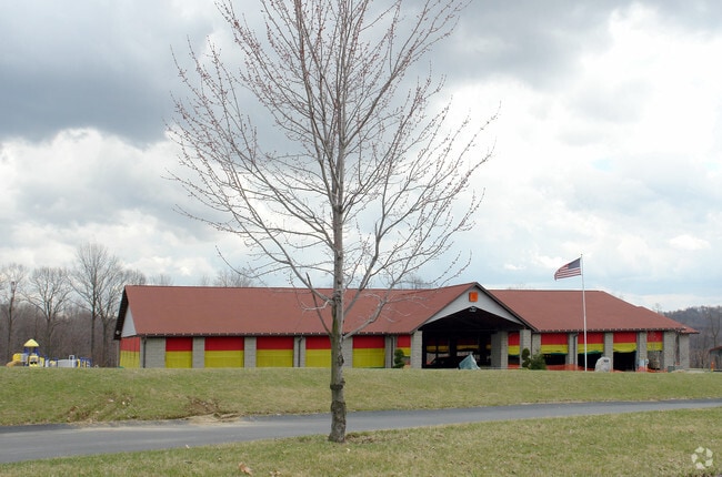
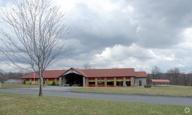
Property Detail
1877 Shriners Way
Pittsburgh, PA
PLAN OF SUBDIVISION FOR SYRIA TEMPLE HOLDING CORP TRACT #1 = (36.8 ALD) LITTLE DEER CREEK RD ((50 FT) R/W TO BE ABANDONED = (1.5 ALD)
0529-H-00035-0000-00
Allegheny
Amusementpark
Pennsylvania
B and X Area of moderate flood hazard, usually the area between the limits of the 100-year and 500-year floods.
35
2026
43.30 AC
2026
Northeast Pittsburgh
419000
Pittsburgh
NEARBY LISTINGS FOR SALE OR LEASE
-
-
View all Cheswick listings for sale on LoopNet.com
DEMOGRAPHICS near 1877 Shriners Way
1 mile
3 mile
5 mile
2025 Total Population
3,204
27,767
81,647
2030 Population
3,143
27,404
80,765
Pop Growth 2025-2030
(1.90%)
(1.31%)
(1.08%)
Average Age
48
46
45
2025 Total Households
1,490
12,763
36,509
HH Growth 2025-2030
(2.15%)
(1.35%)
(1.11%)
Median Household Inc
$66,769
$77,544
$73,147
Avg Household Size
2.00
2.10
2.20
2025 Avg HH Vehicles
2.00
2.00
2.00
Median Home Value
$166,980
$237,618
$191,421
Median Year Built
1955
1963
1958
Nearby Places
Map Layers
Map Styles
 Street
 Aerial
Layers
 Traffic
 Biking
Places
Listings with unknown addresses are not visible on the map
- Restaurants
- Banks
- Shops
- Fitness
- Groceries
PUBLIC TRANSPORTATION
AIRPORT
Pittsburgh International
Drive
Walk
Distance
Pittsburgh International
52 min
31.9 mi
Arnold Palmer Regional
Drive
Walk
Distance
Arnold Palmer Regional
58 min
38.8 mi
Nearby Properties
Address
Land Use
TOTAL SIZE
Lot Size
Zoning
Address
Land Use
TOTAL SIZE
Lot Size
Zoning
36.44 AC
Address
Land Use
TOTAL SIZE
Lot Size
Zoning
11.28 AC
Address
Land Use
TOTAL SIZE
Lot Size
Zoning
23.45 AC
Address
Land Use
TOTAL SIZE
Lot Size
Zoning
42.71 AC
Address
Land Use
TOTAL SIZE
Lot Size
Zoning
528.43 AC
Address
Land Use
TOTAL SIZE
Lot Size
Zoning
119.91 AC
Address
Land Use
TOTAL SIZE
Lot Size
Zoning
6.35 AC
Address
Land Use
TOTAL SIZE
Lot Size
Zoning
5.44 AC
Address
Land Use
TOTAL SIZE
Lot Size
Zoning
15.37 AC
Address
Land Use
TOTAL SIZE
Lot Size
Zoning
48.10 AC
Address
Land Use
TOTAL SIZE
Lot Size
Zoning
54.90 AC
Address
Land Use
TOTAL SIZE
Lot Size
Zoning
13.68 AC
Address
Land Use
TOTAL SIZE
Lot Size
Zoning
84.40 AC
Address
Land Use
TOTAL SIZE
Lot Size
Zoning
37.84 AC
Address
Land Use
TOTAL SIZE
Lot Size
Zoning
Address
Land Use
TOTAL SIZE
Lot Size
Zoning
72.14 AC
Address
Land Use
TOTAL SIZE
Lot Size
Zoning
Address
Land Use
TOTAL SIZE
Lot Size
Zoning
10.20 AC
Address
Land Use
TOTAL SIZE
Lot Size
Zoning
1.21 AC
Address
Land Use
TOTAL SIZE
Lot Size
Zoning
23.95 AC
Address
Land Use
TOTAL SIZE
Lot Size
Zoning
Address
Land Use
TOTAL SIZE
Lot Size
Zoning
889 SF
31.93 AC
Address
Land Use
TOTAL SIZE
Lot Size
Zoning
Address
Land Use
TOTAL SIZE
Lot Size
Zoning
21.20 AC
Address
Land Use
TOTAL SIZE
Lot Size
Zoning
1.48 AC
Address
Land Use
TOTAL SIZE
Lot Size
Zoning
1.81 AC
Address
Land Use
TOTAL SIZE
Lot Size
Zoning
114.41 AC
Address
Land Use
TOTAL SIZE
Lot Size
Zoning
20.10 AC
Address
Land Use
TOTAL SIZE
Lot Size
Zoning
Address
Land Use
TOTAL SIZE
Lot Size
Zoning
The World's #1 Commercial Real Estate Marketplace
Connect with us
© 2026 CoStar Group
The information above has been obtained from sources believed reliable. While we do not doubt its accuracy we have not verified it and make no guarantee, warranty or representation about it. It is your responsibility to independently confirm its accuracy and completeness. Any projections, opinions, assumptions, or estimates used are for example only and do not represent the current or future performance of the property. The value of this transaction to you depends on tax and other factors which should be evaluated by your tax, financial, and legal advisors. You and your advisors should conduct a careful, independent investigation of the property to determine to your satisfaction the suitability of the property for your needs.