Property Record
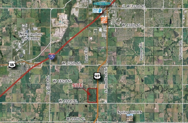
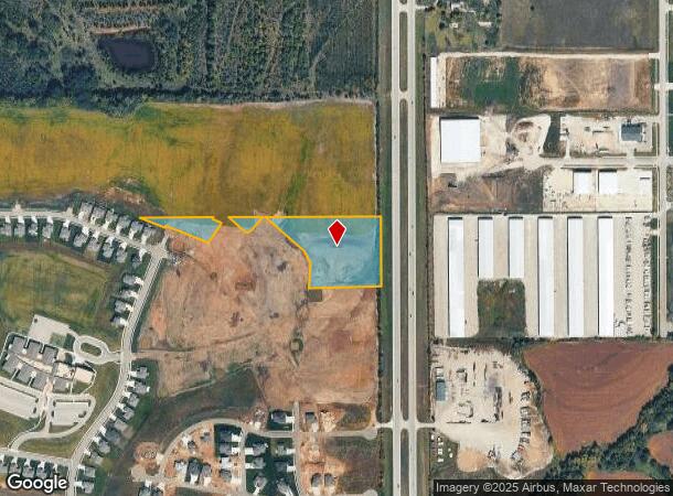
18780 S Ns Nt, Spring Hill, KS 66083
NEARBY LISTINGS FOR SALE OR LEASE
Property Detail
18780 S Ns Nt
Kansas City, MO-KS
Dayton Crk First
EF231435-2001
35-14-23 W 1/2 EX N 1/2 NW1/4 EX N 660' S 1/2 NW1/4 EX 2.52 AC EX 3.56 AC EX 1.44 AC IN RDS EX 8 TRS PLATTED 26.131 AC 1.671 AC 27.185 AC 14.19 AC 17 .848AC 44.052 AC EX 29.447 AC & 24.2117 AC & EX 3.761 AC IN RDS 5.5733 ACS M/L
Farms
Johnson
X
Kansas
20091C0123G
5.09 AC
2024
South Johnson County
2024
Kansas City
053801
DEMOGRAPHICS near 18780 S Ns Nt
1 mile
3 mile
5 mile
2024 Total Population
1,041
8,225
43,129
2029 Population
1,132
8,825
45,563
Pop Growth 2024-2029
+ 8.74%
+ 7.29%
+ 5.64%
Average Age
41
39
37
2024 Total Households
378
2,901
14,561
HH Growth 2024-2029
+ 8.73%
+ 7.34%
+ 5.84%
Median Household Inc
$84,701
$94,793
$100,160
Avg Household Size
2.70
2.80
2.90
2024 Avg HH Vehicles
3.00
2.00
2.00
Median Home Value
$363,636
$338,781
$310,339
Median Year Built
2000
2003
2002
Nearby Places
Map Layers
Map Styles
 Street
 Aerial
Transit
 Traffic
 Biking
Places
Listings with unknown addresses are not visible on the map
- Restaurants
- Banks
- Shops
- Fitness
- Groceries
Nearby Properties
Address
Land Use
TOTAL SIZE
Lot Size
Zoning
Address
Land Use
TOTAL SIZE
Lot Size
Zoning
1,060,732 SF
57.62 AC
MP-2
Address
Land Use
TOTAL SIZE
Lot Size
Zoning
327,169 SF
141.81 AC
R-R
Address
Land Use
TOTAL SIZE
Lot Size
Zoning
71,086 SF
22.76 AC
R-3
Address
Land Use
TOTAL SIZE
Lot Size
Zoning
720,320 SF
39.19 AC
MP-2
Address
Land Use
TOTAL SIZE
Lot Size
Zoning
320,835 SF
57.95 AC
M-2
Address
Land Use
TOTAL SIZE
Lot Size
Zoning
508,664 SF
29.46 AC
MP-2
Address
Land Use
TOTAL SIZE
Lot Size
Zoning
102,280 SF
30.53 AC
RP-4
Address
Land Use
TOTAL SIZE
Lot Size
Zoning
70,643 SF
18.45 AC
RP-1
Address
Land Use
TOTAL SIZE
Lot Size
Zoning
71,221 SF
14.16 AC
Address
Land Use
TOTAL SIZE
Lot Size
Zoning
244,992 SF
15.75 AC
MP-2
Address
Land Use
TOTAL SIZE
Lot Size
Zoning
212,032 SF
9.53 AC
RUR
Address
Land Use
TOTAL SIZE
Lot Size
Zoning
65,691 SF
11.51 AC
RP-1
Address
Land Use
TOTAL SIZE
Lot Size
Zoning
137,412 SF
12.02 AC
M-2
Address
Land Use
TOTAL SIZE
Lot Size
Zoning
127,880 SF
5.77 AC
M-2
Address
Land Use
TOTAL SIZE
Lot Size
Zoning
601,670 SF
37.16 AC
MP-2
Address
Land Use
TOTAL SIZE
Lot Size
Zoning
41,250 SF
6.01 AC
R-R
Address
Land Use
TOTAL SIZE
Lot Size
Zoning
446,772 SF
28.49 AC
MP-2
Address
Land Use
TOTAL SIZE
Lot Size
Zoning
476,083 SF
63.47 AC
M-1
Address
Land Use
TOTAL SIZE
Lot Size
Zoning
533,662 SF
24.67 AC
MP-2
Address
Land Use
TOTAL SIZE
Lot Size
Zoning
109,026 SF
11.21 AC
M-1
Address
Land Use
TOTAL SIZE
Lot Size
Zoning
92.22 AC
R-1
Address
Land Use
TOTAL SIZE
Lot Size
Zoning
14,098 SF
3.06 AC
CTY RUR
Address
Land Use
TOTAL SIZE
Lot Size
Zoning
10,440 SF
155.35 AC
RP-1
Address
Land Use
TOTAL SIZE
Lot Size
Zoning
48,000 SF
13.82 AC
R-R
Address
Land Use
TOTAL SIZE
Lot Size
Zoning
231,750 SF
22.02 AC
M-1
Address
Land Use
TOTAL SIZE
Lot Size
Zoning
39,800 SF
4.75 AC
M-1
Address
Land Use
TOTAL SIZE
Lot Size
Zoning
12,556 SF
2.60 AC
M-1
Address
Land Use
TOTAL SIZE
Lot Size
Zoning
204,744 SF
13.37 AC
M-1
Address
Land Use
TOTAL SIZE
Lot Size
Zoning
15,876 SF
6.49 AC
R-1
Address
Land Use
TOTAL SIZE
Lot Size
Zoning
20.31 AC
R-R
The World's #1 Commercial Real Estate Marketplace
Connect with us
© 2026 CoStar Group
The information above has been obtained from sources believed reliable. While we do not doubt its accuracy we have not verified it and make no guarantee, warranty or representation about it. It is your responsibility to independently confirm its accuracy and completeness. Any projections, opinions, assumptions, or estimates used are for example only and do not represent the current or future performance of the property. The value of this transaction to you depends on tax and other factors which should be evaluated by your tax, financial, and legal advisors. You and your advisors should conduct a careful, independent investigation of the property to determine to your satisfaction the suitability of the property for your needs.