Property Record
18797 Highway 99E, Hubbard, OR 97032
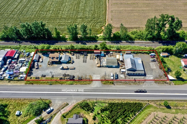

Property Detail
18797 Highway 99E
511253
ACRES 1.12
Officebuilding
Marion
C
Oregon
B and X Area of moderate flood hazard, usually the area between the limits of the 100-year and 500-year floods.
1.12 AC
2024
Marion County
2025
Portland
010202
Salem, OR
6,994 SF
NEARBY LISTINGS FOR SALE OR LEASE
DEMOGRAPHICS near 18797 Highway 99E
1 mile
3 mile
5 mile
2024 Total Population
3,355
8,526
33,792
2029 Population
3,417
8,658
34,189
Pop Growth 2024-2029
+ 1.85%
+ 1.55%
+ 1.17%
Average Age
38
39
40
2024 Total Households
1,080
2,781
10,955
HH Growth 2024-2029
+ 2.04%
+ 1.62%
+ 1.29%
Median Household Inc
$99,176
$92,024
$73,697
Avg Household Size
3.10
3.00
3.00
2024 Avg HH Vehicles
2.00
2.00
2.00
Median Home Value
$465,145
$472,222
$415,421
Median Year Built
1980
1981
1976
Nearby Places
Map Layers
Map Styles
 Street
 Aerial
Transit
 Traffic
 Biking
Places
Listings with unknown addresses are not visible on the map
- Restaurants
- Banks
- Shops
- Fitness
- Groceries
PUBLIC TRANSPORTATION
COMMUTER RAIL
Wilsonville (Westside Express Service - Tri-County Metropolitan Transportation District of Oregon Rail (TriMet Rail))
Drive
Walk
Distance
Wilsonville (Westside Express Service - Tri-County Metropolitan Transportation District of Oregon Rail (TriMet Rail))
15 min
9.3 mi
AIRPORT
Portland International
Drive
Walk
Distance
Portland International
53 min
36.9 mi
Freight Ports
Port of Portland
Drive
Walk
Distance
Port of Portland
39 min
28.1 mi
SALE & LEASE HISTORY
LISTING DATE
SALE/LEASE

Jul 14, 2022
For Sale
Nearby Properties
Address
Land Use
TOTAL SIZE
Lot Size
Zoning
Address
Land Use
TOTAL SIZE
Lot Size
Zoning
Address
Land Use
TOTAL SIZE
Lot Size
Zoning
20 SF
100.66 AC
P
Address
Land Use
TOTAL SIZE
Lot Size
Zoning
Address
Land Use
TOTAL SIZE
Lot Size
Zoning
152,390 SF
20.40 AC
IP
Address
Land Use
TOTAL SIZE
Lot Size
Zoning
6.22 AC
IL
Address
Land Use
TOTAL SIZE
Lot Size
Zoning
47,709 SF
29.13 AC
IP
Address
Land Use
TOTAL SIZE
Lot Size
Zoning
39,666 SF
8.39 AC
I
Address
Land Use
TOTAL SIZE
Lot Size
Zoning
81,772 SF
3.92 AC
IC
Address
Land Use
TOTAL SIZE
Lot Size
Zoning
39,323 SF
15.38 AC
IL
Address
Land Use
TOTAL SIZE
Lot Size
Zoning
86,020 SF
3.83 AC
IC
Address
Land Use
TOTAL SIZE
Lot Size
Zoning
Address
Land Use
TOTAL SIZE
Lot Size
Zoning
8.33 AC
IP
Address
Land Use
TOTAL SIZE
Lot Size
Zoning
40,900 SF
10.91 AC
IP
Address
Land Use
TOTAL SIZE
Lot Size
Zoning
7,339 SF
5.67 AC
RI
Address
Land Use
TOTAL SIZE
Lot Size
Zoning
Address
Land Use
TOTAL SIZE
Lot Size
Zoning
Address
Land Use
TOTAL SIZE
Lot Size
Zoning
50,000 SF
2.38 AC
I
Address
Land Use
TOTAL SIZE
Lot Size
Zoning
38,681 SF
2.08 AC
I
Address
Land Use
TOTAL SIZE
Lot Size
Zoning
5.24 AC
IL
Address
Land Use
TOTAL SIZE
Lot Size
Zoning
34,800 SF
1.79 AC
C
Address
Land Use
TOTAL SIZE
Lot Size
Zoning
Address
Land Use
TOTAL SIZE
Lot Size
Zoning
25,685 SF
3.19 AC
I
Address
Land Use
TOTAL SIZE
Lot Size
Zoning
Address
Land Use
TOTAL SIZE
Lot Size
Zoning
30,845 SF
4.38 AC
IC
Address
Land Use
TOTAL SIZE
Lot Size
Zoning
25,480 SF
1.73 AC
I
Address
Land Use
TOTAL SIZE
Lot Size
Zoning
30,736 SF
8.16 AC
I
Address
Land Use
TOTAL SIZE
Lot Size
Zoning
Address
Land Use
TOTAL SIZE
Lot Size
Zoning
Address
Land Use
TOTAL SIZE
Lot Size
Zoning
48,100 SF
2.76 AC
I
Address
Land Use
TOTAL SIZE
Lot Size
Zoning
37,500 SF
1.60 AC
ID
The World's #1 Commercial Real Estate Marketplace
Connect with us
© 2026 CoStar Group
The information above has been obtained from sources believed reliable. While we do not doubt its accuracy we have not verified it and make no guarantee, warranty or representation about it. It is your responsibility to independently confirm its accuracy and completeness. Any projections, opinions, assumptions, or estimates used are for example only and do not represent the current or future performance of the property. The value of this transaction to you depends on tax and other factors which should be evaluated by your tax, financial, and legal advisors. You and your advisors should conduct a careful, independent investigation of the property to determine to your satisfaction the suitability of the property for your needs.