Property Record
188 Boundary Rd, Marlboro, NJ 07746
NEARBY LISTINGS FOR SALE OR LEASE
-
-
View all Marlboro listings for sale on LoopNet.com
Property Detail
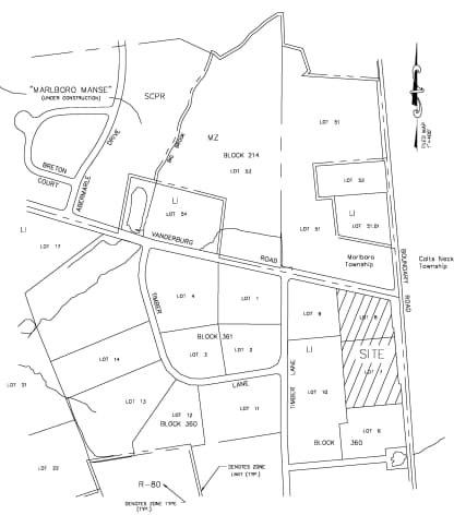
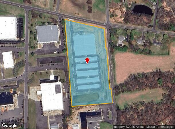
188 Boundary Rd
30-00360-0000-00007
Monmouth
Commercialnec
New Jersey
X
7.1
34025C0161F
7.84 AC
2024
Western Monmouth
2025
Northern New Jersey
809701
New York-Jersey City-White Plains, NY-NJ
DEMOGRAPHICS near 188 Boundary Rd
1 Mile
3 Mile
5 Mile
2024 Total Population
1,904
24,519
78,127
2029 Population
1,869
24,142
77,037
Pop Growth 2024-2029
(1.84%)
(1.54%)
(1.40%)
Average Age
41
43
42
2024 Total Households
591
7,921
25,839
HH Growth 2024-2029
(2.03%)
(1.72%)
(1.55%)
Median Household Inc
$226,686
$189,580
$153,548
Avg Household Size
3.10
3.00
2.90
2024 Avg HH Vehicles
3.00
2.00
2.00
Median Home Value
$708,815
$709,964
$651,137
Median Year Built
1990
1984
1981
Nearby Places
Map Layers
Map Styles
 Street
 Aerial
- Restaurants
- Banks
- Shops
- Fitness
- Groceries
PUBLIC TRANSPORTATION
COMMUTER RAIL
Aberdeen Matawan (North Jersey Coast Line - NJ Transit Commuter Rail (NJ Transit))
DRIVE
WALK
Distance
Aberdeen Matawan (North Jersey Coast Line - NJ Transit Commuter Rail (NJ Transit))
15 min
9.0 mi
Hazlet (North Jersey Coast Line - NJ Transit Commuter Rail (NJ Transit))
DRIVE
WALK
Distance
Hazlet (North Jersey Coast Line - NJ Transit Commuter Rail (NJ Transit))
17 min
9.5 mi
AIRPORT
Newark Liberty International
DRIVE
WALK
Distance
Newark Liberty International
49 min
39.2 mi
Freight Ports
New York Container Terminal
DRIVE
WALK
Distance
New York Container Terminal
42 min
31.4 mi
SALE & LEASE HISTORY
LISTING DATE
SALE/LEASE

Sep 24, 2016
For Sale
Jun 05, 2019
For Sale
Nearby Properties
Address
Land Use
TOTAL SIZE
Lot Size
Zoning
Address
Land Use
TOTAL SIZE
Lot Size
Zoning
69.99 AC
AG
Address
Land Use
TOTAL SIZE
Lot Size
Zoning
93.79 AC
R-60
Address
Land Use
TOTAL SIZE
Lot Size
Zoning
1,800 SF
83.93 AC
R120
Address
Land Use
TOTAL SIZE
Lot Size
Zoning
46 AC
CF
Address
Land Use
TOTAL SIZE
Lot Size
Zoning
22.95 AC
A-1
Address
Land Use
TOTAL SIZE
Lot Size
Zoning
30.80 AC
CF
Address
Land Use
TOTAL SIZE
Lot Size
Zoning
98,617 SF
10 AC
A/LC
Address
Land Use
TOTAL SIZE
Lot Size
Zoning
4,812 SF
179.80 AC
A-1
Address
Land Use
TOTAL SIZE
Lot Size
Zoning
13,365 SF
3 AC
AG
Address
Land Use
TOTAL SIZE
Lot Size
Zoning
65,708 SF
13.65 AC
C-5
Address
Land Use
TOTAL SIZE
Lot Size
Zoning
17,342 SF
64.55 AC
ROS
Address
Land Use
TOTAL SIZE
Lot Size
Zoning
21.35 AC
CF
Address
Land Use
TOTAL SIZE
Lot Size
Zoning
34.52 AC
R-60
Address
Land Use
TOTAL SIZE
Lot Size
Zoning
33.73 AC
R-60
Address
Land Use
TOTAL SIZE
Lot Size
Zoning
411 AC
ROS
Address
Land Use
TOTAL SIZE
Lot Size
Zoning
6,072 SF
31.59 AC
MP
Address
Land Use
TOTAL SIZE
Lot Size
Zoning
35,229 SF
17.64 AC
CF
Address
Land Use
TOTAL SIZE
Lot Size
Zoning
27.87 AC
A-1
Address
Land Use
TOTAL SIZE
Lot Size
Zoning
60,436 SF
9.23 AC
C-2
Address
Land Use
TOTAL SIZE
Lot Size
Zoning
30.82 AC
R-60
Address
Land Use
TOTAL SIZE
Lot Size
Zoning
50,970 SF
4.32 AC
C2
Address
Land Use
TOTAL SIZE
Lot Size
Zoning
16,803 SF
19.87 AC
R302
Address
Land Use
TOTAL SIZE
Lot Size
Zoning
28.10 AC
R-25
Address
Land Use
TOTAL SIZE
Lot Size
Zoning
15.17 AC
A-1
Address
Land Use
TOTAL SIZE
Lot Size
Zoning
30,350 SF
7.02 AC
C2
Address
Land Use
TOTAL SIZE
Lot Size
Zoning
10,734 SF
25.16 AC
AG
Address
Land Use
TOTAL SIZE
Lot Size
Zoning
13,626 SF
2.35 AC
AG
Address
Land Use
TOTAL SIZE
Lot Size
Zoning
360.97 AC
ROS
Address
Land Use
TOTAL SIZE
Lot Size
Zoning
8.27 AC
B-1
The World's #1 Commercial Real Estate Marketplace
Connect with us
© 2025 CoStar Group
The information above has been obtained from sources believed reliable. While we do not doubt its accuracy we have not verified it and make no guarantee, warranty or representation about it. It is your responsibility to independently confirm its accuracy and completeness. Any projections, opinions, assumptions, or estimates used are for example only and do not represent the current or future performance of the property. The value of this transaction to you depends on tax and other factors which should be evaluated by your tax, financial, and legal advisors. You and your advisors should conduct a careful, independent investigation of the property to determine to your satisfaction the suitability of the property for your needs.